


<< Our Photo Pages >> Simon's Cross (Padiham) - Ancient Cross in England in Lancashire
Submitted by Anne T on Sunday, 17 February 2019 Page Views: 1407
Early Medieval (Dark Age)Site Name: Simon's Cross (Padiham) Alternative Name: Simon's Stone (Padiham); Wart Well (Simonstone)Country: England
NOTE: This site is 1.63 km away from the location you searched for.
County: Lancashire Type: Ancient Cross
Nearest Town: Burnley / Clitheroe Nearest Village: Simonstone / Sabden
Map Ref: SD77603609
Latitude: 53.820597N Longitude: 2.341738W
Condition:
| 5 | Perfect |
| 4 | Almost Perfect |
| 3 | Reasonable but with some damage |
| 2 | Ruined but still recognisable as an ancient site |
| 1 | Pretty much destroyed, possibly visible as crop marks |
| 0 | No data. |
| -1 | Completely destroyed |
| 5 | Superb |
| 4 | Good |
| 3 | Ordinary |
| 2 | Not Good |
| 1 | Awful |
| 0 | No data. |
| 5 | Can be driven to, probably with disabled access |
| 4 | Short walk on a footpath |
| 3 | Requiring a bit more of a walk |
| 2 | A long walk |
| 1 | In the middle of nowhere, a nightmare to find |
| 0 | No data. |
| 5 | co-ordinates taken by GPS or official recorded co-ordinates |
| 4 | co-ordinates scaled from a detailed map |
| 3 | co-ordinates scaled from a bad map |
| 2 | co-ordinates of the nearest village |
| 1 | co-ordinates of the nearest town |
| 0 | no data |
Be the first person to rate this site - see the 'Contribute!' box in the right hand menu.
Internal Links:
External Links:
 (PID:223045)")
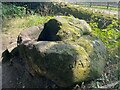
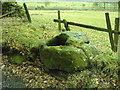
The Journal of Antiquities tells us about this large boulder with a deep socket hole which used to mark the parish boundary of Simonstone and Read in the late 13th or early 14th century - see their entry for Simon’s Cross, Simonstone, Near Padiham, Lancashire. The cross may have been a wayside cross for pilgrims on route to Whalley Abbey. The Journal includes photographs, a description, directions for finding this cross base, local folklore and a list of reference sources for more information.
The Journal adds the water which collected in the socket hole was reputed to be a cure for warts. The JoA adds: "On the side of the boulder the words ‘SIMON’S CROSS’ are carved along with a faint cross symbol and some Latin-type letters: maybe J A M and J W and a date that looks like 1860. The cross-shaft that would have fitted into this boulder having long since disappeared, but where did it go to?"
Note: Have you visited this site? Do you have any photographs or information to add?
You may be viewing yesterday's version of this page. To see the most up to date information please register for a free account.
 (PID:223046)")
Do not use the above information on other web sites or publications without permission of the contributor.
Nearby Images from Geograph Britain and Ireland:
©2022(licence)
©2019(licence)
©2010(licence)
©2009(licence)
©2010(licence)
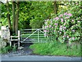
The above images may not be of the site on this page, they are loaded from Geograph.
Please Submit an Image of this site or go out and take one for us!
Click here to see more info for this site
Nearby sites
Key: Red: member's photo, Blue: 3rd party photo, Yellow: other image, Green: no photo - please go there and take one, Grey: site destroyed
Download sites to:
KML (Google Earth)
GPX (GPS waypoints)
CSV (Garmin/Navman)
CSV (Excel)
To unlock full downloads you need to sign up as a Contributory Member. Otherwise downloads are limited to 50 sites.
Turn off the page maps and other distractions
Nearby sites listing. In the following links * = Image available
2.2km NNW 349° Coffin Stone (Sabden) Standing Stone (Menhir) (SD77173830)
2.4km NW 317° Jeppe Knave's Grave* Cairn (SD75993782)
2.4km N 353° Solar Wheel Year Stone (Sabden) Rock Art (SD77323846)
2.9km N 4° Lower Apronful of Stones (Pendle Hill) Cairn (SD778390)
3.1km WSW 259° Portfield* Hillfort (SD7458135499)
3.2km N 5° Devil's Apronful (Pendle Hill) Cairn (SD779393)
3.2km WNW 292° Wisa's Well (Wiswell)* Holy Well or Sacred Spring (SD746373)
3.6km N 11° Badger Wells Cairn Cairn (SD783396)
4.0km WNW 283° High Wall Well (Bramley Meade)* Holy Well or Sacred Spring (SD73663702)
4.3km W 270° St Mary and All Saints Church (Whalley)* Sculptured Stone (SD733361)
4.3km W 271° Whalley Crosses* Ancient Cross (SD73263616)
5.2km ENE 63° St Chad's Well, Tinedale Farm, Spen Brook.* Holy Well or Sacred Spring (SD82253845)
5.3km ENE 60° Newchurch-in-Pendle* Stone Circle (SD822387)
5.5km NNE 13° Pendle Hill* Round Barrow(s) (SD789414)
5.8km NE 54° Jinny Well* Holy Well or Sacred Spring (SD8238039461)
6.7km WNW 295° The Great Mitton Cross* Ancient Cross (SD7156438954)
6.8km W 280° Winckley Lowe II* Round Barrow(s) (SD7084937308)
7.1km W 281° Winckley Lowe I* Round Barrow(s) (SD7064337457)
7.1km N 2° Worsaw Hill Burial Mound* Round Barrow(s) (SD77934323)
7.3km ESE 114° The Burnley Cross* Ancient Cross (SD8423533080)
7.3km WNW 299° Mitton Green Cross (Great Mitton) Ancient Cross (SD7121739613)
7.3km ESE 114° Shorey Well (Burnley) Holy Well or Sacred Spring (SD8424433069)
7.3km NNE 24° Pendle Hill Ringwork and Barrow Hillfort (SD806428)
7.6km NNW 329° Peg o'Nell's Well* Holy Well or Sacred Spring (SD73684266)
7.8km W 280° Billington Round Barrow(s) (SD699375)
View more nearby sites and additional images


 We would like to know more about this location. Please feel free to add a brief description and any relevant information in your own language.
 Wir möchten mehr über diese Stätte erfahren. Bitte zögern Sie nicht, eine kurze Beschreibung und relevante Informationen in Deutsch hinzuzufügen.
 Nous aimerions en savoir encore un peu sur les lieux. S'il vous plaît n'hesitez pas à ajouter une courte description et tous les renseignements pertinents dans votre propre langue.
 Quisieramos informarnos un poco más de las lugares. No dude en añadir una breve descripción y otros datos relevantes en su propio idioma.