


<< Our Photo Pages >> Horseshoe Wood Settlement - Ancient Village or Settlement in Scotland in Scottish Borders
Submitted by Anne T on Saturday, 09 May 2015 Page Views: 1926
Multi-periodSite Name: Horseshoe Wood Settlement Alternative Name: Horseshoe Wood Scooped Settlement; Horseshoe Wood MoundCountry: Scotland
NOTE: This site is 0.7 km away from the location you searched for.
County: Scottish Borders Type: Ancient Village or Settlement
Nearest Town: Jedburgh Nearest Village: Hownam
Map Ref: NT78511891
Latitude: 55.463554N Longitude: 2.341421W
Condition:
| 5 | Perfect |
| 4 | Almost Perfect |
| 3 | Reasonable but with some damage |
| 2 | Ruined but still recognisable as an ancient site |
| 1 | Pretty much destroyed, possibly visible as crop marks |
| 0 | No data. |
| -1 | Completely destroyed |
| 5 | Superb |
| 4 | Good |
| 3 | Ordinary |
| 2 | Not Good |
| 1 | Awful |
| 0 | No data. |
| 5 | Can be driven to, probably with disabled access |
| 4 | Short walk on a footpath |
| 3 | Requiring a bit more of a walk |
| 2 | A long walk |
| 1 | In the middle of nowhere, a nightmare to find |
| 0 | No data. |
| 5 | co-ordinates taken by GPS or official recorded co-ordinates |
| 4 | co-ordinates scaled from a detailed map |
| 3 | co-ordinates scaled from a bad map |
| 2 | co-ordinates of the nearest village |
| 1 | co-ordinates of the nearest town |
| 0 | no data |
Internal Links:
External Links:
I have visited· I would like to visit
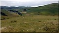
Anne T visited on 4th May 2015 - their rating: Cond: 2 Amb: 4 Access: 3 Horseshoe Wood Settlement, Hownam, Scottish Borders: After having parked in the sleepy little hamlet of Hownam, a footpath called The Street sets off near the village/community hall, leading off to the left of the main road up into the hills.
Just starting up The Street, there is a field to the right hand side of the road which holds what looks like another standing stone, so we stopped to investigate.
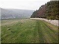
Continuing, we then passed a couple of houses on a gravelled roadway the footpath enters farmland which rises reasonably gently up towards Horseshoe Wood. At the time of our visit, the footpath was covered in manure (obviously had a herd of cattle on it recently). The lambs were very curious as to who these strangers were who were walking through their land, only moving from the warm soil of the path at the very last minute.
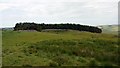
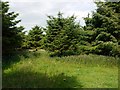
Horseshoe Wood runs to the left of the footpath, contained within a stone wall. Towards the higher end of the wood the wall has been demolished in two places and through this the mound of the settlement rises distinctly behind it.
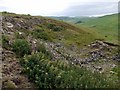
Exploring, we found it to be an elongated mound, made even clearer by the fact it has no trees growing on it, with two circular scoops taken out of the left hand side; the first has a small tree growing out of it.
Curious, as this mound is relatively near the Standing Stone (only a couple of hundred metres), we took photographs and tried to find out more after our visit, but couldn't - but the description sounded identical to the RCAHMS/Canmore record of a scooped settlement nearby.
We thought perhaps this mound had been missed because it has been hidden by the wall and the trees within the wood.
If anyone can shed any further light on this mound, I'd be delighted to hear more.
")
This mound can easily be missed as it is hidden behind the stone wall of Horseshoe Wood, just before reaching the Horseshoe Wood Standing Stone.
Parking in Hownam Village, follow The Street trackway/footpath over the fields to the first wood which sits to the left hand side of the track - this is Horsehoe Wood. The stone wall has been demolished in two places (to allow access?) and the mound is clearly visible as a grassy mound which rises to the height of around 5-6 metres and is defined by no trees growing on top of it (there are the occasional old tree stumps but these are decaying and were cut down some time ago).
This grassy mound appears to be around the same size and shape as that upon which the Horseshoe Standing Stone sits upon. Walking up onto it, to the left hand side and just over half way along, there are two circular scoops which have been taken out of the mound, which could either be the remains of hut circles, the sides of which have tumbled down the slope, or quarrying.
Whilst this site is not formally recorded (we asked ourselves if it had been missed because of its position hidden behind the wall) this mound/settlement/enclosure appeared to us almost as described in the Canmore/RCAHMS record for Hownam Burns Scooped Settlement (their site reference 57963), but I am happy to be corrected.
You may be viewing yesterday's version of this page. To see the most up to date information please register for a free account.
")
")
")
Do not use the above information on other web sites or publications without permission of the contributor.
Nearby Images from Geograph Britain and Ireland:
©2009(licence)
©2009(licence)
©2009(licence)
©2009(licence)
©2022(licence)
The above images may not be of the site on this page, they are loaded from Geograph.
Please Submit an Image of this site or go out and take one for us!
Click here to see more info for this site
Nearby sites
Key: Red: member's photo, Blue: 3rd party photo, Yellow: other image, Green: no photo - please go there and take one, Grey: site destroyed
Download sites to:
KML (Google Earth)
GPX (GPS waypoints)
CSV (Garmin/Navman)
CSV (Excel)
To unlock full downloads you need to sign up as a Contributory Member. Otherwise downloads are limited to 50 sites.
Turn off the page maps and other distractions
Nearby sites listing. In the following links * = Image available
230m E 92° Horseshoe Wood (Hownam)* Standing Stone (Menhir) (NT78741890)
679m ENE 60° The Shearers* Stone Row / Alignment (NT79101925)
714m NE 47° Hownam Rings Hill Fort* Hillfort (NT79041939)
1.9km SSW 197° Little Heuch Law Cairn* Cairn (NT77921705)
2.2km SSW 199° Dodlaw Burn* Standing Stone (Menhir) (NT77791681)
2.4km SSW 192° Dodlaw Cairn Round Cairn (NT77991655)
2.9km SW 218° Chatto Craig* Hillfort (NT76701662)
3.3km NNE 20° Hownam Law Hillfort* Hillfort (NT7964022000)
3.8km WSW 237° Five Stanes A* Stone Circle (NT75261686)
3.9km SW 223° Dere Street stone* Standing Stone (Menhir) (NT75801604)
4.3km E 86° Calroust Hillfort* Hillfort (NT828192)
4.3km SW 230° Trestle Cairn* Stone Circle (NT75181612)
4.5km SW 230° Five Stanes B Stone Circle (NT7516)
4.8km SW 225° Black Knowe (Borders)* Standing Stone (Menhir) (NT75131554)
4.8km SW 225° Dere Street Cairn* Round Cairn (NT75061552)
5.6km SW 222° Falla Knowe Cairn* Cairn (NT74711475)
5.9km S 181° Standard Knowe Cairn (NT78411300)
6.3km E 81° Sourhope Hillfort* Hillfort (NT8475219825)
6.6km ENE 77° Fasset Hill (Sourhope)* Ancient Village or Settlement (NT8492520359)
6.6km SSW 195° Woden Law* Hillfort (NT76771254)
7.2km ESE 105° Stoney Knowe Hillfort* Hillfort (NT855170)
7.4km E 87° Bonnielaws Hillfort* Hillfort (NT8589319312)
7.4km SW 226° Dark Wood* Cairn (NT73111377)
7.7km S 190° Hindhope Hill Cairn* Cairn (NT7710811310)
7.8km SSW 192° Hindhope Hill Hillfort* Hillfort (NT76811127)
View more nearby sites and additional images


 We would like to know more about this location. Please feel free to add a brief description and any relevant information in your own language.
 Wir möchten mehr über diese Stätte erfahren. Bitte zögern Sie nicht, eine kurze Beschreibung und relevante Informationen in Deutsch hinzuzufügen.
 Nous aimerions en savoir encore un peu sur les lieux. S'il vous plaît n'hesitez pas à ajouter une courte description et tous les renseignements pertinents dans votre propre langue.
 Quisieramos informarnos un poco más de las lugares. No dude en añadir una breve descripción y otros datos relevantes en su propio idioma.