


<< Our Photo Pages >> Cam Long Down Hillfort - Hillfort in England in Gloucestershire
Submitted by dooclay on Sunday, 07 May 2023 Page Views: 358
Iron Age and Later PrehistorySite Name: Cam Long Down HillfortCountry: England County: Gloucestershire Type: Hillfort
Nearest Town: Dursley Nearest Village: Upper Cam
Map Ref: ST7753399507
Latitude: 51.693859N Longitude: 2.326443W
Condition:
| 5 | Perfect |
| 4 | Almost Perfect |
| 3 | Reasonable but with some damage |
| 2 | Ruined but still recognisable as an ancient site |
| 1 | Pretty much destroyed, possibly visible as crop marks |
| 0 | No data. |
| -1 | Completely destroyed |
| 5 | Superb |
| 4 | Good |
| 3 | Ordinary |
| 2 | Not Good |
| 1 | Awful |
| 0 | No data. |
| 5 | Can be driven to, probably with disabled access |
| 4 | Short walk on a footpath |
| 3 | Requiring a bit more of a walk |
| 2 | A long walk |
| 1 | In the middle of nowhere, a nightmare to find |
| 0 | No data. |
| 5 | co-ordinates taken by GPS or official recorded co-ordinates |
| 4 | co-ordinates scaled from a detailed map |
| 3 | co-ordinates scaled from a bad map |
| 2 | co-ordinates of the nearest village |
| 1 | co-ordinates of the nearest town |
| 0 | no data |
Internal Links:
External Links:
")
Listed as Possible Hillfort on Gloucestershire Know Your Place Site. The entry includes contradictory interpretations for and against the hillfort.
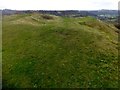
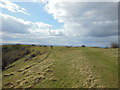
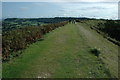
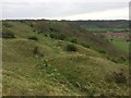
'Slight signs of the earthworks of a possible hillfort can be seen on the top of Cam Long Down. On the N side of the hill are several stretches of a slight bank. At E end of the hill are the remains of "many ancient pit dwellings" among which have been found large quantities of worked flints. The hill-top which has been scarred by quarrying does not appear to be a suitable position for a hillfort'.
Also:
(ST 775995) 'Slight signs of the earthworks of a possible hill fort can be seen on the top of Cam Long Down. On the north side of the hill are several stretches of a slight bank, and at the eastern end of the hill are the remains of "many ancient pit dwellings", among which have been found large quantities of worked flints'.
and:
'The quarrying is also visible across the summit of the hill and was also mapped. None of the features visible were indicative of a hillfort'.
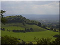
Whatever you believe the views up there are great.......
You may be viewing yesterday's version of this page. To see the most up to date information please register for a free account.
")
")
Do not use the above information on other web sites or publications without permission of the contributor.
Nearby Images from Geograph Britain and Ireland:
©2015(licence)
©2013(licence)
©2005(licence)
©2009(licence)
©2017(licence)
The above images may not be of the site on this page, they are loaded from Geograph.
Please Submit an Image of this site or go out and take one for us!
Click here to see more info for this site
Nearby sites
Key: Red: member's photo, Blue: 3rd party photo, Yellow: other image, Green: no photo - please go there and take one, Grey: site destroyed
Download sites to:
KML (Google Earth)
GPX (GPS waypoints)
CSV (Garmin/Navman)
CSV (Excel)
To unlock full downloads you need to sign up as a Contributory Member. Otherwise downloads are limited to 50 sites.
Turn off the page maps and other distractions
Nearby sites listing. In the following links * = Image available
1.1km ESE 123° Uley Bury* Hillfort (ST78459891)
1.5km ENE 70° Hetty Pegler's Tump* Passage Grave (SO78960003)
2.3km SW 231° The Broadwell* Holy Well or Sacred Spring (ST75749807)
2.6km NE 46° Nympsfield* Long Barrow (SO79400132)
2.6km S 174° Rowden Wood* Chambered Tomb (ST77819692)
2.6km S 184° Folly Wood* Chambered Tomb (ST77339689)
2.7km NE 42° Soldier's Grave* Round Barrow(s) (SO79350150)
2.7km W 265° Dursley Merestone* Marker Stone (ST748993)
3.1km NE 48° Buckholt Wood* Chambered Tomb (SO79860157)
3.5km SSE 157° Wotton Under Edge Cursus Cursus (ST789963)
4.1km SSE 148° Symonds Hall Farm* Long Barrow (ST79719599)
4.1km WSW 249° Drakestone Camp* Misc. Earthwork (ST73679801)
4.3km NE 55° Woodchester Beaker Barrow* Round Barrow(s) (SO81100198)
4.5km E 91° Lutheredge Earthworks* Misc. Earthwork (ST82089943)
4.8km ESE 113° Woodleaze Farm* Long Barrow (ST820976)
5.0km ENE 58° Kings Stanley Dyke* Misc. Earthwork (SO818021)
5.2km ENE 63° Bown Hill Bowl Barrow* Round Barrow(s) (SO82240184)
5.3km ENE 64° Bown Hill Long Barrow* Long Barrow (SO82290179)
5.3km ESE 111° Woodleaze Bowl Barrow* Round Barrow(s) (ST82489757)
5.4km SSW 211° Brackenbury Ditches* Promontory Fort / Cliff Castle (ST74709485)
6.1km SE 143° Kingscote Standing Stones* Standing Stones (ST81189467)
6.3km S 180° Blackquarries Hill* Chambered Tomb (ST77529323)
6.3km NE 55° The Toots (King's Stanley)* Long Barrow (SO82700310)
6.9km SSE 148° Brock Hill Round Barrow(s) (ST81219363)
7.3km ENE 60° Woodchester Roman Villa* Ancient Village or Settlement (SO8394503128)
View more nearby sites and additional images


 We would like to know more about this location. Please feel free to add a brief description and any relevant information in your own language.
 Wir möchten mehr über diese Stätte erfahren. Bitte zögern Sie nicht, eine kurze Beschreibung und relevante Informationen in Deutsch hinzuzufügen.
 Nous aimerions en savoir encore un peu sur les lieux. S'il vous plaît n'hesitez pas à ajouter une courte description et tous les renseignements pertinents dans votre propre langue.
 Quisieramos informarnos un poco más de las lugares. No dude en añadir una breve descripción y otros datos relevantes en su propio idioma.