 with our Megalithic Portal iPhone app")


<< Our Photo Pages >> Whippalow Hill - Barrow Cemetery in England in Greater Manchester
Submitted by vagabondnma on Sunday, 27 March 2005 Page Views: 6512
Neolithic and Bronze AgeSite Name: Whippalow Hill Alternative Name: Whipney Lane LowCountry: England County: Greater Manchester Type: Barrow Cemetery
Nearest Town: Bury Nearest Village: Hawkshaw
Map Ref: SD76921477
Latitude: 53.628945N Longitude: 2.350468W
Condition:
| 5 | Perfect |
| 4 | Almost Perfect |
| 3 | Reasonable but with some damage |
| 2 | Ruined but still recognisable as an ancient site |
| 1 | Pretty much destroyed, possibly visible as crop marks |
| 0 | No data. |
| -1 | Completely destroyed |
| 5 | Superb |
| 4 | Good |
| 3 | Ordinary |
| 2 | Not Good |
| 1 | Awful |
| 0 | No data. |
| 5 | Can be driven to, probably with disabled access |
| 4 | Short walk on a footpath |
| 3 | Requiring a bit more of a walk |
| 2 | A long walk |
| 1 | In the middle of nowhere, a nightmare to find |
| 0 | No data. |
| 5 | co-ordinates taken by GPS or official recorded co-ordinates |
| 4 | co-ordinates scaled from a detailed map |
| 3 | co-ordinates scaled from a bad map |
| 2 | co-ordinates of the nearest village |
| 1 | co-ordinates of the nearest town |
| 0 | no data |
Internal Links:
External Links:
")
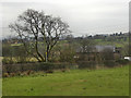
Background: According to Bury Archaeological Society this is a 'Neolithic Burial Site'. I have no more information than that. It is a large grass covered mound that looks man made to me.
The area: Hawkshaw is a beautiful village on the outskirts of Bury in Greater Manchester (or Lancashire as some of us still say). It is close to Bolton also. Hawkshaw has several Burial sites from the Neolithic and Bronze Age (I will be reporting/photographing more soon). It is on the edge of the pennines - Holcombe Hill is very close to the site and is quite imposing. Neolithic mounds tended to be in less dramatic places than Bronze Age ones, they were in more sheltered spots, with some privacy as well as being visible only from certain places. These particular 'lowes' are dotted either side of the main road (probably an ancient route) and they were probably visible from each other in their day....?
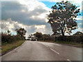
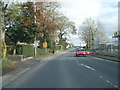
Access: Come off the A676 and turn up the road where you see the sign for the Firing Range. Park at the bottom of this road - it has sort of parking bays. Then walk back to the main road, carefully cross it - (they go fast) and go over the stone stile opposite heading South East along a track (Whipney Lane). You will pass two very rough gateposts (old standing stones?). Keep going another 100m or so and it is on your right. It's in the next field. You are on a public footpath, it is not. The farmer (I think) lives in Kenyon's Farm - (SU150762). A local lady said he is very nice, so I am going to ask him before I go up it).
You may be viewing yesterday's version of this page. To see the most up to date information please register for a free account.
")
")
Do not use the above information on other web sites or publications without permission of the contributor.
Nearby Images from Geograph Britain and Ireland:
©2012(licence)
©2007(licence)
©2007(licence)
©2010(licence)
©2019(licence)
The above images may not be of the site on this page, they are loaded from Geograph.
Please Submit an Image of this site or go out and take one for us!
Click here to see more info for this site
Nearby sites
Key: Red: member's photo, Blue: 3rd party photo, Yellow: other image, Green: no photo - please go there and take one, Grey: site destroyed
Download sites to:
KML (Google Earth)
GPX (GPS waypoints)
CSV (Garmin/Navman)
CSV (Excel)
To unlock full downloads you need to sign up as a Contributory Member. Otherwise downloads are limited to 50 sites.
Turn off the page maps and other distractions
Nearby sites listing. In the following links * = Image available
798m W 269° Dodd Lee* Barrow Cemetery (SD76121476)
1.8km SW 233° Affetside Cross (Lancashire) Ancient Cross (SD7546613689)
1.8km SW 233° Affetside Cross (Bury)* Ancient Cross (SD7546613686)
1.8km NW 308° Carve Hill Low* Barrow Cemetery (SD755159)
3.3km ESE 124° Castlesteads (Walmersley)* Hillfort (SD797129)
3.9km ENE 67° Whitelow* Cairn (SD80501626)
4.3km SSW 204° Dry Hillock Marker Stone* Marker Stone (SD7511310830)
4.9km N 11° Robin Hood's Well, Haslingden* Holy Well or Sacred Spring (SD77861954)
5.3km ESE 107° Walmersley Golf Club stone* Modern Stone Circle etc (SD82011319)
5.4km WNW 281° Cheetham Close* Stone Circle (SD71631586)
6.2km ESE 111° Castle Hill, Heywood Hillfort (SD827125)
6.3km E 88° Wind Hill Cheesden* Round Barrow(s) (SD8326214945)
7.3km SW 221° St Peter's Church (Bolton)* Ancient Cross (SD721093)
7.3km SW 218° Haulgh (Bolton) Cairn (SD72420899)
7.4km WSW 242° Toothill Long Barrow* Long Barrow (SD704113)
7.6km NE 51° Waugh's Well (Edenfield) Holy Well or Sacred Spring (SD82871957)
7.8km S 181° Radcliffe Hillfort (SD767070)
7.9km SW 223° Bolton Museum* Museum (SD715090)
8.3km W 262° Horrocks Moor Barrow* Artificial Mound (SD687136)
8.4km WSW 258° Priests Crown* Long Barrow (SD68621307)
8.8km W 261° Moortop Barrows* Round Barrow(s) (SD682134)
9.2km WSW 259° Brown Stones* Stone Row / Alignment (SD679130)
9.2km WSW 246° The Doffcocker Cross Ancient Cross (SD6846411027)
9.3km WSW 250° Thurstones Row Stone Row / Alignment (SD681116)
9.5km NW 309° White Hall* Round Barrow(s) (SD696208)
View more nearby sites and additional images


 We would like to know more about this location. Please feel free to add a brief description and any relevant information in your own language.
 Wir möchten mehr über diese Stätte erfahren. Bitte zögern Sie nicht, eine kurze Beschreibung und relevante Informationen in Deutsch hinzuzufügen.
 Nous aimerions en savoir encore un peu sur les lieux. S'il vous plaît n'hesitez pas à ajouter une courte description et tous les renseignements pertinents dans votre propre langue.
 Quisieramos informarnos un poco más de las lugares. No dude en añadir una breve descripción y otros datos relevantes en su propio idioma.