


<< Our Photo Pages >> Worsaw Hill Burial Mound - Round Barrow(s) in England in Lancashire
Submitted by Sunny100 on Friday, 29 July 2016 Page Views: 3316
Neolithic and Bronze AgeSite Name: Worsaw Hill Burial Mound Alternative Name: Worsaw End MoundCountry: England
NOTE: This site is 0.234 km away from the location you searched for.
County: Lancashire Type: Round Barrow(s)
Nearest Town: Clitheroe Nearest Village: Downham
Map Ref: SD77934323
Latitude: 53.884784N Longitude: 2.337241W
Condition:
| 5 | Perfect |
| 4 | Almost Perfect |
| 3 | Reasonable but with some damage |
| 2 | Ruined but still recognisable as an ancient site |
| 1 | Pretty much destroyed, possibly visible as crop marks |
| 0 | No data. |
| -1 | Completely destroyed |
| 5 | Superb |
| 4 | Good |
| 3 | Ordinary |
| 2 | Not Good |
| 1 | Awful |
| 0 | No data. |
| 5 | Can be driven to, probably with disabled access |
| 4 | Short walk on a footpath |
| 3 | Requiring a bit more of a walk |
| 2 | A long walk |
| 1 | In the middle of nowhere, a nightmare to find |
| 0 | No data. |
| 5 | co-ordinates taken by GPS or official recorded co-ordinates |
| 4 | co-ordinates scaled from a detailed map |
| 3 | co-ordinates scaled from a bad map |
| 2 | co-ordinates of the nearest village |
| 1 | co-ordinates of the nearest town |
| 0 | no data |
Internal Links:
External Links:
I have visited· I would like to visit
SumDoood would like to visit
FrothNinja visited - their rating: Cond: 3 Amb: 3 Access: 2 On private land
")
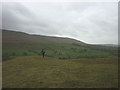
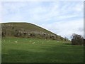
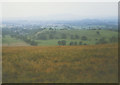
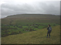
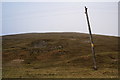
A Bronze Age mound (round barrow or bowl barrow) located at the south-eastern side of Worsaw Hill, between Downham and Worston, Lancashire.The hill is actually a coral reef knoll, the largest in this area, and is 725 ft high (221m). The grassy mound is 6 ft high and roughly 16m X 13m). There is a slight hollow at the centre, which might be due to a past excavation or maybe robbery?There is little if any information about this site.
The mound is difficult to reach - unless you like a strenuous climb and a long walk around the bottom of the hill to the lower slopes. The walls around the side of the hill are good for crinoid fossil hunting!
There is an entry on Pastscape Monument No. 44629 which says this is the site of a possible tumulus ("this is a limestone hill") with no external ditch. The Journal of Antiquities also features an entry for Worsaw Hill Burial Mound, near Downham, Lancashire, which includes directions for reaching this site, together with photographs of the barrow and the crinoid fossils ("Worsaw Hill is the largest reef knoll in the area"), a description, and a list of reference sources for more information.
You may be viewing yesterday's version of this page. To see the most up to date information please register for a free account.
")
Do not use the above information on other web sites or publications without permission of the contributor.
Nearby Images from Geograph Britain and Ireland:
©2014(licence)
©2008(licence)
©2006(licence)
©2014(licence)
©2010(licence)
The above images may not be of the site on this page, they are loaded from Geograph.
Please Submit an Image of this site or go out and take one for us!
Click here to see more info for this site
Nearby sites
Key: Red: member's photo, Blue: 3rd party photo, Yellow: other image, Green: no photo - please go there and take one, Grey: site destroyed
Download sites to:
KML (Google Earth)
GPX (GPS waypoints)
CSV (Garmin/Navman)
CSV (Excel)
To unlock full downloads you need to sign up as a Contributory Member. Otherwise downloads are limited to 50 sites.
Turn off the page maps and other distractions
Nearby sites listing. In the following links * = Image available
1.1km NNE 14° Great Stone (Downham)* Standing Stone (Menhir) (SD782443)
2.1km SSE 152° Pendle Hill* Round Barrow(s) (SD789414)
2.7km E 99° Pendle Hill Ringwork and Barrow Hillfort (SD806428)
3.6km S 174° Badger Wells Cairn Cairn (SD783396)
3.9km S 180° Devil's Apronful (Pendle Hill) Cairn (SD779393)
4.2km S 181° Lower Apronful of Stones (Pendle Hill) Cairn (SD778390)
4.3km W 262° Peg o'Nell's Well* Holy Well or Sacred Spring (SD73684266)
4.8km S 187° Solar Wheel Year Stone (Sabden) Rock Art (SD77323846)
5.0km S 188° Coffin Stone (Sabden) Standing Stone (Menhir) (SD77173830)
5.2km W 275° Pinder Hill (Waddington) Cairn (SD72724370)
5.7km SSW 199° Jeppe Knave's Grave* Cairn (SD75993782)
5.8km SE 130° Jinny Well* Holy Well or Sacred Spring (SD8238039461)
6.0km NNE 19° Fooden Spring Holy Well or Sacred Spring (SD7993548892)
6.1km N 6° St Peter and St Paul's Church, Bolton-by-Bowland* Sculptured Stone (SD786493)
6.2km SE 136° Newchurch-in-Pendle* Stone Circle (SD822387)
6.3km ENE 71° Middop Earthworks* Misc. Earthwork (SD839452)
6.4km SE 138° St Chad's Well, Tinedale Farm, Spen Brook.* Holy Well or Sacred Spring (SD82253845)
6.8km SSW 209° Wisa's Well (Wiswell)* Holy Well or Sacred Spring (SD746373)
7.0km ESE 102° Aedmer's Mound (Admergill)* Artificial Mound (SD8482941718)
7.1km S 182° Simon's Cross (Padiham)* Ancient Cross (SD77603609)
7.5km SW 214° High Wall Well (Bramley Meade)* Holy Well or Sacred Spring (SD73663702)
7.6km E 100° Blacko Cross (Blacko Hill) Ancient Cross (SD85414187)
7.6km WSW 241° Mitton Green Cross (Great Mitton) Ancient Cross (SD7121739613)
7.7km SW 236° The Great Mitton Cross* Ancient Cross (SD7156438954)
7.7km NE 55° Bomber Camp (Gisburn) Ancient Village or Settlement (SD8429547626)
View more nearby sites and additional images


 We would like to know more about this location. Please feel free to add a brief description and any relevant information in your own language.
 Wir möchten mehr über diese Stätte erfahren. Bitte zögern Sie nicht, eine kurze Beschreibung und relevante Informationen in Deutsch hinzuzufügen.
 Nous aimerions en savoir encore un peu sur les lieux. S'il vous plaît n'hesitez pas à ajouter une courte description et tous les renseignements pertinents dans votre propre langue.
 Quisieramos informarnos un poco más de las lugares. No dude en añadir una breve descripción y otros datos relevantes en su propio idioma.