 with our Megalithic Portal iPhone app")


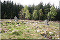
<< Our Photo Pages >> Clune Wood - Cairn in Scotland in Aberdeenshire
Submitted by hamilton on Monday, 26 August 2002 Page Views: 8759
Neolithic and Bronze AgeSite Name: Clune WoodCountry: Scotland
NOTE: This site is 1.443 km away from the location you searched for.
County: Aberdeenshire Type: Cairn
Map Ref: NO7934695036 Landranger Map Number: 38
Latitude: 57.045933N Longitude: 2.342036W
Condition:
| 5 | Perfect |
| 4 | Almost Perfect |
| 3 | Reasonable but with some damage |
| 2 | Ruined but still recognisable as an ancient site |
| 1 | Pretty much destroyed, possibly visible as crop marks |
| 0 | No data. |
| -1 | Completely destroyed |
| 5 | Superb |
| 4 | Good |
| 3 | Ordinary |
| 2 | Not Good |
| 1 | Awful |
| 0 | No data. |
| 5 | Can be driven to, probably with disabled access |
| 4 | Short walk on a footpath |
| 3 | Requiring a bit more of a walk |
| 2 | A long walk |
| 1 | In the middle of nowhere, a nightmare to find |
| 0 | No data. |
| 5 | co-ordinates taken by GPS or official recorded co-ordinates |
| 4 | co-ordinates scaled from a detailed map |
| 3 | co-ordinates scaled from a bad map |
| 2 | co-ordinates of the nearest village |
| 1 | co-ordinates of the nearest town |
| 0 | no data |
Internal Links:
External Links:
")
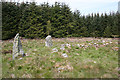
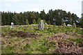
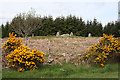
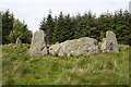
Clune Wood Cairn is nowadays a rather untidy mess, but still an imposing sight nevertheless.
You may be viewing yesterday's version of this page. To see the most up to date information please register for a free account.
Do not use the above information on other web sites or publications without permission of the contributor.
Nearby Images from Geograph Britain and Ireland:
©2015(licence)
©2015(licence)
©2015(licence)
©2015(licence)
©2015(licence)
The above images may not be of the site on this page, they are loaded from Geograph.
Please Submit an Image of this site or go out and take one for us!
Click here to see more info for this site
Nearby sites
Key: Red: member's photo, Blue: 3rd party photo, Yellow: other image, Green: no photo - please go there and take one, Grey: site destroyed
Download sites to:
KML (Google Earth)
GPX (GPS waypoints)
CSV (Garmin/Navman)
CSV (Excel)
To unlock full downloads you need to sign up as a Contributory Member. Otherwise downloads are limited to 50 sites.
Turn off the page maps and other distractions
Nearby sites listing. In the following links * = Image available
149m SE 125° Raes Of Clune* Stone Circle (NO7946894949)
1.5km ESE 111° Elsick Mounth* Ancient Trackway (NO807945)
2.0km E 91° South Brachmont Artificial Mound (NO814950)
2.9km NNW 332° Park House* Class I Pictish Symbol Stone (NO77979765)
3.3km SSW 200° Cairn-mon-earn* Cairn (NO782919)
4.0km WSW 256° Cairnfauld* Stone Circle (NO754941)
5.2km SE 145° Auquhollie* Standing Stone (Menhir) (NO82339080)
5.2km W 266° Barns Enclosure Ancient Village or Settlement (NO741947)
5.3km W 281° Milton of Crathes* Class I Pictish Symbol Stone (NO741961)
5.5km WSW 256° Cairnshee Wood* Cairn (NO740937)
5.6km W 260° Cairnshee Enclosure Souterrain (Fogou, Earth House) (NO738941)
5.6km WNW 287° Warren Field* Ancient Village or Settlement (NO73939670)
5.9km SE 139° Raedykes NW* Stone Circle (NO832906)
5.9km ENE 65° Standingstones* Standing Stones (NO847975)
5.9km SE 139° Campstone Hill Ring Cairn (NO832905)
5.9km SE 139° Raedykes SE* Stone Circle (NO832905)
6.1km W 278° Balbridie Neolithic Timber Hall Ancient Village or Settlement (NO733959)
6.5km WSW 245° East Mulloch Stone Circle (NO734923)
6.8km SE 135° Raedykes Roman Camp* Hillfort (NO842902)
6.9km W 261° Tilquhillie Stone Circle (Remains)* Stone Circle (NO72529402)
6.9km WSW 240° Westerton Hut Circle Ancient Village or Settlement (NO733916)
7.0km SSE 155° Glenton Hill Enclosure Ancient Village or Settlement (NO823887)
7.2km W 262° Tilquhillie Standing Stone* Standing Stone (Menhir) (NO72239410)
7.4km SE 137° Newbigging Earthwork Ancient Village or Settlement (NO844896)
7.6km WSW 248° Esslie The Lesser* Stone Circle (NO72259215)
View more nearby sites and additional images


 We would like to know more about this location. Please feel free to add a brief description and any relevant information in your own language.
 Wir möchten mehr über diese Stätte erfahren. Bitte zögern Sie nicht, eine kurze Beschreibung und relevante Informationen in Deutsch hinzuzufügen.
 Nous aimerions en savoir encore un peu sur les lieux. S'il vous plaît n'hesitez pas à ajouter une courte description et tous les renseignements pertinents dans votre propre langue.
 Quisieramos informarnos un poco más de las lugares. No dude en añadir una breve descripción y otros datos relevantes en su propio idioma.