Featured: Ark of Secrets - Neolithic spirit alive in the Middle Ages

Ark of Secrets - Neolithic spirit alive in the Middle Ages

Solving Stonehenge, the new key to an ancient enigma

Solving Stonehenge, the new key to an ancient enigma

Who's Online

There are currently, 320 guests and 2 members online.

You are a guest. To join in, please register for free by clicking here

Sponsors

<< Our Photo Pages >> Bathampton - Standing Stones in England in Somerset

Submitted by Andy B on Wednesday, 12 October 2011  Page Views: 22693

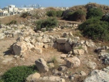
Neolithic and Bronze AgeSite Name: Bathampton
Country: England
NOTE: This site is 1.184 km away from the location you searched for.

County: Somerset Type: Standing Stones
Nearest Town: Bath  Nearest Village: Bathampton
Map Ref: ST772652  Landranger Map Number: 172
Latitude: 51.385382N  Longitude: 2.329027W
Condition:
5Perfect
4Almost Perfect
3Reasonable but with some damage
2Ruined but still recognisable as an ancient site
1Pretty much destroyed, possibly visible as crop marks
0No data.
-1Completely destroyed
1 Ambience:
5Superb
4Good
3Ordinary
2Not Good
1Awful
0No data.
3 Access:
5Can be driven to, probably with disabled access
4Short walk on a footpath
3Requiring a bit more of a walk
2A long walk
1In the middle of nowhere, a nightmare to find
0No data.
4 Accuracy:
5co-ordinates taken by GPS or official recorded co-ordinates
4co-ordinates scaled from a detailed map
3co-ordinates scaled from a bad map
2co-ordinates of the nearest village
1co-ordinates of the nearest town
0no data
4

Internal Links:
External Links:

Bathampton
Bathampton submitted by Andy B : Overlay of resistance and magnetometer surveys. The right hand image shows the possible stones of a lost stone circle indicated by white circles. A plan showing where two ellipses were sensed by dowser Paul Daw has also been overlaid. Although these supposed stone positions have not been confirmed it was these plans that spurred the BACAS members to do this survey work In the 40m square res... (Vote or comment on this photo)
Possible stone circle in Somerset. There is now nothing to see on the surface to suggest the former presence of stone circles or avenues in the area, we have only the word of an antiquarian of the mid nineteenth century (Scarth, 1857), writing in a paper about other archaeological features.

It is curious that John Skinner, a more meticulous recorder of antiquities, did not include any sign of stones here on the down in his maps of 1822 but showed stones elsewhere nearby. This leads to some doubt as to the existence of the monument. Scarth was talking about a big monument as he mentions that some 30 stones were already removed.

There are three standing stones in Bushy Norwood Field, still on high, flat ground, about 1 km to the south. However, these are known to be part of an eighteenth century horse race course. Other stones in the field were bulldozed in the nineteen forties . The presence of these stones has previously caused confusion with the stones of a circle.

Geophysical surveying was carried out earlier this year at the location where stone circles had been indicated by the Reverend Scarth in 1857 and Tratman in 1958. Dowsing in 2009 had suggested two circles at this site.

Paul Daw the dowser who produced plans which spurred on our research appears to have taken Tratman’s location literally and claimed to have discovered a small stone circle centred on an exact definition of Tratman’s approximate location, and another small circle/ellipse a little to the north-west.

We initially surveyed an area which encompassed his claimed monuments. Using instruments to produce two-dimensional plans, we found anomalies which may represent the remains of the megalithic monument close to, but not exactly at, Mr Daw’s location.

On the basis of the magnetometry and resistivity surveys we can state that we may have found part of the monument. Our data are far from conclusive and it would take excavation to confirm that we have located the circle. The data are not sufficient for a realistic estimate of the shape or diameter of the circle. There were no signs of a possible second circle to the northwest, but the ground here had been disturbed in modern times.

If this is the site of a demolished stone circle and avenues, its appearance may have been similar to those at Stanton Drew but its setting is very different. The siting has more in common with Kingston Russell (Dorset), Rollright or Arbor Low. More in the Bath and Camerton Archaeological Society report: The search for Bathampton Down Stone Circles - Geophysical surveys by Rod Thomas and John Oswin (PDF) downloadable from the BACAS web site.

Other References: Scarth, H M, 1857. On ancient earthworks in the neighbourhood of Bath. Journal of the British Archaeological Association V13 no 2, 98-113.
Skinner, J, 1821, British Library MS ADD 33671.
Tratman, E K, 1958.The lost stone circles of North Somerset. Proc UBSS 8, 110-118.

Note: BACAS geophysics results 'suggestive' of part of a stone circle long thought to have existed on Bathampton Down
You may be viewing yesterday's version of this page. To see the most up to date information please register for a free account.


bathampton
bathampton submitted by saroson : This stone with holes was a glacial deposit stood on end in the 18th century to mark out a horse racing circuit The site on the golf course shows no sign of any circle,but some stones found in a rough circle in a adjacent field. (Vote or comment on this photo)

Bathampton Camp
Bathampton Camp submitted by Bladup : Bathampton Camp, the bank and ditch on the western side of the fort. (Vote or comment on this photo)

Bathampton
Bathampton submitted by Terence_Meaden : This stone with holes was a glacial deposit stood on end in the 18th century to mark out a horse racing circuit (2 comments - Vote or comment on this photo)

Bathampton Camp
Bathampton Camp submitted by camperman : The precipitous slopes to the east of the Camp overlooking the Avon valley. The area has been quarried for the famous Bath Stone which is evident along these eastern slopes. (Vote or comment on this photo)

Bathampton Camp
Bathampton Camp submitted by camperman : Bank and ditch on the south eastern section of the camp, now heavily wooded adjacent to the golf course. (Vote or comment on this photo)

Bathampton Camp
Bathampton Camp submitted by camperman : The bank and ditch evident on the western side of the Camp, now part of the golf course.

Bathampton Camp
Bathampton Camp submitted by camperman : Bathampton Camp viewed from the south, the extent of the earthworks again denoted by the edge of the tree line.

Bathampton Camp
Bathampton Camp submitted by camperman : Aerial view of Bathampton Camp from the east. The line of earthworks are denoted by the ring of woodland.

Bathampton Camp
Bathampton Camp submitted by Bladup : Bathampton Camp, the bank and ditch on the western side of the fort.

Bathampton Camp
Bathampton Camp submitted by Bladup

Bathampton Camp
Bathampton Camp submitted by Bladup

Bathampton Camp
Bathampton Camp submitted by Bladup : Bathampton Camp, the bank and ditch on the north western side of the fort.

Bathampton Camp
Bathampton Camp submitted by Bladup : Bathampton Camp, the bank on the north western side of the fort.

Bathampton Camp
Bathampton Camp submitted by Bladup : Bathampton Camp, the bank on the southern side of the fort.

Bathampton Camp
Bathampton Camp submitted by Bladup : Bathampton Camp, the bank on the Southern side of the fort.

Bathampton Camp
Bathampton Camp submitted by Bladup : Bathampton Camp, this big cave on the eastern side of the fort had been recently lived in!!!

Bathampton Camp
Bathampton Camp submitted by Bladup : Bathampton Camp, another cave on the eastern side of the fort.

Bathampton Camp
Bathampton Camp submitted by Bladup : Bathampton Camp, a cave on the eastern side of the fort.

Bathampton Camp
Bathampton Camp submitted by Bladup : Bathampton Camp, the bank on the south side of the fort.

Bathampton Camp
Bathampton Camp submitted by Bladup : Bathampton Camp, rock shelter at ST767646.

Bathampton Camp
Bathampton Camp submitted by Bladup : Bathampton Camp, the smaller north west barrow at ST76696465. As you can see some animal (fox?) likes to visit this barrow.

Bathampton Camp
Bathampton Camp submitted by Bladup : Bathampton Camp, the south east barrow at ST76766460.

Bathampton Round Barrow 2
Bathampton Round Barrow 2 submitted by 4clydesdale7 : The Barrow from the Bath Golf Club Car Park with Sham Castle to the rear

Bathampton Round Barrow 2
Bathampton Round Barrow 2 submitted by 4clydesdale7 : The Barrow from Sham Castle

Bathampton Camp
Bathampton Camp submitted by 4clydesdale7 : The Northwestern Bank with part of Bath Golf Course in the foreground - watch out for small fast flying white objects!

These are just the first 25 photos of Bathampton. If you log in with a free user account you will be able to see our entire collection.

Do not use the above information on other web sites or publications without permission of the contributor.
Click here to see more info for this site

Nearby sites

Click here to view sites on an interactive OS map

Key: Red: member's photo, Blue: 3rd party photo, Yellow: other image, Green: no photo - please go there and take one, Grey: site destroyed

Download sites to:
KML (Google Earth)
GPX (GPS waypoints)
CSV (Garmin/Navman)
CSV (Excel)

To unlock full downloads you need to sign up as a Contributory Member. Otherwise downloads are limited to 50 sites.


Turn off the page maps and other distractions

Nearby sites listing. In the following links * = Image available
 307m SE 126° Bathampton Camp* Hillfort (ST77456502)
 665m WSW 242° Bathampton Round Barrow 2* Round Barrow(s) (ST76616489)
 1.4km NW 304° Kensington Meadows Holed Megalith Holed Stone
 2.2km W 264° Bath Postal Museum* Museum (ST7504564998)
 2.2km WSW 257° Sacred Spring, Bath* Holy Well or Sacred Spring (ST7505364726)
 2.8km N 353° Solsbury Hill* Hillfort (ST76876797)
 3.2km NW 311° St Mary's Well (Charlcombe)* Holy Well or Sacred Spring (ST748673)
 3.2km E 81° Monk's Conduit (Monkton Farleigh)* Holy Well or Sacred Spring (ST8036265692)
 3.2km SE 144° Conkwell well* Holy Well or Sacred Spring (ST791626)
 3.3km SE 131° Jug's Grave* Round Barrow(s) (ST79696305)
 3.3km SE 137° Conkwell stone circle* Stone Circle (ST79456280)
 4.0km SSE 168° Shingle Bell* Holy Well or Sacred Spring (ST780613)
 5.4km SSE 148° Winsley Chambered Tomb (ST800606)
 5.4km NNE 26° Three Shires Stones* Modern Stone Circle etc (ST7961070021)
 5.5km WNW 302° St Alphages Well* Holy Well or Sacred Spring (ST72606815)
 5.5km S 183° Hill Farm Barrow (Somerset) Round Barrow(s) (ST76855969)
 5.5km SE 144° Turleigh Trows* Holy Well or Sacred Spring (ST8044960725)
 5.9km S 190° The Giants Graves Cist (ST761594)
 6.0km S 181° Beacon Barrow (Somerset) Round Barrow(s) (ST77095920)
 6.2km NE 55° Box Rock Circus* Modern Stone Circle etc (ST823687)
 6.2km ENE 59° Becket's Well (Box) Holy Well or Sacred Spring (ST825684)
 6.6km NW 323° Cold Ashton Round Barrows* Round Barrow(s) (ST73257045)
 6.7km SE 131° Ladywell (Bradford on Avon)* Holy Well or Sacred Spring (ST823608)
 6.7km SE 129° St Laurence's Church (Bradford on Avon)* Early Christian Sculptured Stone (ST8241960914)
 6.8km WNW 303° Lansdown Camp* Misc. Earthwork (ST71446892)
View more nearby sites and additional images

<< Luttra 16:1

Vårkumlastenen >>

Please add your thoughts on this site

Understanding the Neolithic

Understanding the Neolithic

Sponsors

Auto-Translation (Google)

Translate from English into:

"Bathampton" | Login/Create an Account | 6 News and Comments
  
Go back to top of page    Comments are owned by the poster. We aren't responsible for their content.
Re: Bathampton by Oakmist on Wednesday, 18 March 2020
(User Info | Send a Message)
Scarth has mixed up east and west . He says ‘The western part portion of the camp facing Bathford..’ - anyone who has been on the Down will realise Bathford is to the East. The positioning of the geological survey carried out by Rod Thomas was based on Scarth’s article and was on the west of the enclosure so no where near the circles that Scarth had seen. There is an obvious collection of about 30 stones to the NW of the enclosure facing Bathampton village and from where Bathford can be seen - these could be the ones Scarth referred to.

Rod Thomas‘ states that ‘ It is known that the stones are derived from the 17-18th century racecourse..’ this is somewhat too definitive. Most of the racecourse was underneath the current Bath University site which is 300 metres or more away from the stones in Bushy Norwood and 500 metres from the ones to the North of the enclosure. The Golf Club periodically removes these from its fairways and redeposits them in heaps. Furthermore some of these stones are very large - 12ft long by six feet wide and it would appear to involve to much labour to use them as markers for a Racecourse - unless they were already there. There were also a number of large stones removed from the field to the east of the Dogs Home when the University had it levelled for a new rugby field about 15 years ago - these are a long way to the south of the racecourse position.

It seems fairly likely that the stone avenue and circles as reported by Third Stone Magazine did exist and that some of these stones were used as racecourse markers . It would be difficult to find evidence now as most traces have been destroyed by the building of the University and the Golf Course.

Reference: 3rd Stone 27, Autumn 1997
[ Reply to This ]

Tratman - The lost stone circles of North Somerset by Andy B on Wednesday, 12 October 2011
(User Info | Send a Message)
The referenced paper - Tratman, E K, 1958. The lost stone circles of North Somerset. Proc UBSS 8, 110-118 is downloadable to read thanks to the digitisation work of the UBSS (University of Bristol Spelæological Society)

http://www.ubss.org.uk/resources/proceedings/vol8/UBSS_Proc_8_2_110-118.pdf

http://www.ubss.org.uk/search_literature.php
[ Reply to This ]

Geophysics results 'suggestive' of part of a stone circle on Bathampton Down by Andy B on Monday, 10 October 2011
(User Info | Send a Message)
Rod Thomas and John Oswin write: Geophysical surveying has been carried out on Bathampton Down, Bath at a location where stone circles had been indicated by the Reverend Scarth in 1857 and Tratman in 1958. Dowsing in 2009 had suggested two circles at this site.

Paul Daw the dowser who produced plans which spurred on our research appears to have taken Tratman’s location literally and claimed to have discovered a small stone circle centred on an exact definition of Tratman’s approximate location, and another small circle/ellipse a little to the north-west.

We initially surveyed an area which encompassed his claimed monuments. Using instruments to produce two-dimensional plans, we found anomalies which may represent the remains of the megalithic monument close to, but not exactly at, Mr Daw’s location.

It is on the basis of these that we can state that we may have found part of the monument. Our data are far from conclusive and it would take excavation to confirm that we have located the circle. The data are not sufficient for a realistic estimate of the shape or diameter of the circle. There were no signs of a possible second circle to the northwest, but the ground here had been disturbed in modern times.

If this is the site of a demolished stone circle and avenues, its appearance may have been similar to those at Stanton Drew but its setting is very different. The siting has more in common with Kingston Russell (Dorset), Rollright or Arbor Low.

Read more in the Bath and Camerton Archaeological Society report: The search for Bathampton Down Stone Circles - Geophysical surveys by Rod Thomas and John Oswin (PDF)
http://www.bacas.org.uk/geophysics/BathamptonDownScreenVersion.pdf
downloadable from the BACAS web site.
http://www.bacas.org.uk
[ Reply to This ]

The Secrets of the Downs, Sat 30 July by Andy B on Saturday, 18 June 2011
(User Info | Send a Message)
The Secrets of the Downs

Sat 30 July 11.00–16.00

Investigate the prehistory of Bathampton Down from our base in the University of Bath’s Arts Barn.

Enjoy the displays, find out more about the prehistoric objects from local sites, take a guided walk across the prehistoric landscape, find out about archaeological geophysical surveys and enjoy hands-on family activities such as coil pot making.

Location: University of Bath, ICIA Arts Studios 1 & 2, Claverton Down, Bath BA2 7AY. The University of Bath campus is situated to the east of Bath at Claverton Down, just over a mile from the city centre. As you approach the campus on Norwood Ave, the ICIA Arts Theatre & Arts Complex are on the right, just beyond the Sports Training Village.

Org: Heritage Services, Bath and North East Somerset Council
Name: Lindsey Braidley
Email: Lindsey_braidley@bathnes.gov.uk

Part of the Festival of British Archaeology 2011
[ Reply to This ]

Re: Bathampton by Anonymous on Tuesday, 23 March 2010
Bathampton Down is home to all sorts of prehistoric, Roman and Dark Age activity. But there is no evidence of a stone circle here. The stones with the holes in are glacial deposits (softer shell / stone deposits having worn away) and they were stood on end in the 18th century to mark out a horse racing circuit.
[ Reply to This ]

Re: Bathampton by oldscrote on Wednesday, 12 December 2007
(User Info | Send a Message)
Didnt know any thing about a stone circle on Bathampton Down I was always led to believe that the stones were Saxon boundary markers. Interestingly however is the fact that the wansdyke runs through here but is now buried under Bath university also under the uni is at least one tumulus.Somerset record office web site has a splendid set of old 25 inch to the mile O.S.maps from the turn of the century showing a lot of detail but no stone circle.
[ Reply to This ]

Your Name: Anonymous [ Register Now ]
Subject:


Add your comment or contribution to this page. Spam or offensive posts are deleted immediately, don't even bother

<<< What is five plus one as a number? (Please type the answer to this question in the little box on the left)
You can also embed videos and other things. For Youtube please copy and paste the 'embed code'.
For Google Street View please include Street View in the text.
Create a web link like this: <a href="https://www.megalithic.co.uk">This is a link</a>  

Allowed HTML is:
<p> <b> <i> <a> <img> <em> <br> <strong> <blockquote> <tt> <li> <ol> <ul> <object> <param> <embed> <iframe>

We would like to know more about this location. Please feel free to add a brief description and any relevant information in your own language.
Wir möchten mehr über diese Stätte erfahren. Bitte zögern Sie nicht, eine kurze Beschreibung und relevante Informationen in Deutsch hinzuzufügen.
Nous aimerions en savoir encore un peu sur les lieux. S'il vous plaît n'hesitez pas à ajouter une courte description et tous les renseignements pertinents dans votre propre langue.
Quisieramos informarnos un poco más de las lugares. No dude en añadir una breve descripción y otros datos relevantes en su propio idioma.