


<< Our Photo Pages >> St. Helen's on the Lea (Old Cambus) - Sculptured Stone in Scotland in Scottish Borders
Submitted by alligator on Monday, 24 March 2003 Page Views: 5706
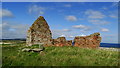
Multi-periodSite Name: St. Helen's on the Lea (Old Cambus) Alternative Name: Old Parish Church; St Helen's Kirk; St Helen's On The Lea; St Helena's ChapelCountry: Scotland County: Scottish Borders Type: Sculptured Stone
Nearest Town: Berwick upon Tweed Nearest Village: Old Cambus
Map Ref: NT8037870676 Landranger Map Number: 67
Latitude: 55.928750N Longitude: 2.315607W
Condition:
| 5 | Perfect |
| 4 | Almost Perfect |
| 3 | Reasonable but with some damage |
| 2 | Ruined but still recognisable as an ancient site |
| 1 | Pretty much destroyed, possibly visible as crop marks |
| 0 | No data. |
| -1 | Completely destroyed |
| 5 | Superb |
| 4 | Good |
| 3 | Ordinary |
| 2 | Not Good |
| 1 | Awful |
| 0 | No data. |
| 5 | Can be driven to, probably with disabled access |
| 4 | Short walk on a footpath |
| 3 | Requiring a bit more of a walk |
| 2 | A long walk |
| 1 | In the middle of nowhere, a nightmare to find |
| 0 | No data. |
| 5 | co-ordinates taken by GPS or official recorded co-ordinates |
| 4 | co-ordinates scaled from a detailed map |
| 3 | co-ordinates scaled from a bad map |
| 2 | co-ordinates of the nearest village |
| 1 | co-ordinates of the nearest town |
| 0 | no data |
Internal Links:
External Links:
I have visited· I would like to visit
h_fenton would like to visit
Anne T visited on 29th Sep 2018 - their rating: Cond: 2 Amb: 4 Access: 4 Hogback at the ruins of St Helen's Chapel, Old Cambus: We found the first hogback easily – at the northern side of the east gable wall, but the second one we hunted for but were unable to find. The cross incised slab we searched for ages, even matching up the angles of the stone to the masonry behind on the Canmore images, but drew a blank. The site was knee deep in grass, with tumbles of stone underneath, so it could have been anywhere. A strimmer would have helped! Similarly with the fragment of hogback on the southern side of the chancel. We found many tumbled stones in the grass, but even looking closely for the tegulations, we didn’t locate it, which was disappointing.
The information board which sits near the junction of the road to the quarry to the footpath to the chapel and Siccar point reads:
“Proceed from here, through the kissing-gate, past the ruin of St Helen’s Chapel and along the top of the steep sea-braes to Siccar Point, arguably the most important geological site in the world. In 1788 it gave James Hutton final proof of his revolutionary claim that the Earth is eons old He based his claim on painstaking observation of rocks and soil over a period of some 30 years. / James Hutton (1726-1797) farmed locally near Reston and was a self-taught geologist. Having already published his theory, he was on a mission to establish the evidence. Before discovering the proof at Siccar Point, by boat with his friends Sir James Hall and John Playfair, Hutton knew what he was looing for and had an idea of where to find it. He sent Sir James, a local landowner from Dunglass and also a geologist, to review the area before embarking on their boat trip below the braes. Sir James may have done this by observing that the stone used to construct field boundaries in the vicinity was (and still is) a combination of rock from above and below the uncomfority (red sandstone and greywacke). / Hutton’s theory released science and philosophy from limitations of the biblical age of the earth (6,000 years old). Though bitterly disputed at the time, it is now accepted as a fundamental of science. James Hutton also expounded with authority of theories as diverse as the nature of light and methods of education, and was a significant agricultural innovator and improver.”
Just before reaching the ruins of St Helen’s, someone has carved an old tree trunk into an L-shape with a toilet seat on top! Note: the gate to the field was locked, and we had to climb over the rather tall gate.
 (PID:186196)")
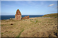
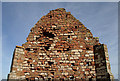
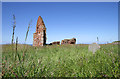
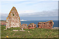
The 12th century Church of St Helen's, Old Cambus, is recorded as Canmore ID 59948 and Canmore ID 59949.
Canmore ID 59948 records a cross slab with cross-arcs, a hogback gravestone damaged at its western end and a fragment of hogback. All three fragments, dated to the eleventh century, were found near the nave in 1908; only the hogback gravestone at the eastern side of the ruined chancel was found during a 2015 visit by the Early Medieval Carved Stones Project.
Located right next to the North Sea, this site is near Siccar Point, "arguably the most important geological site in the world. In 1788 it gave James Hutton final proof of his revolutionary claim that the Earth is eons old." There is an information board by the kissing-gate leading into the field with footpaths going left to the ruins of St Helen's Church and right to Siccar Point.
You may be viewing yesterday's version of this page. To see the most up to date information please register for a free account.
 (PID:186198)")
 (PID:186197)")
Do not use the above information on other web sites or publications without permission of the contributor.
Nearby Images from Geograph Britain and Ireland:
©2010(licence)
©2010(licence)
©2011(licence)
©2016(licence)
©2018(licence)
The above images may not be of the site on this page, they are loaded from Geograph.
Please Submit an Image of this site or go out and take one for us!
Click here to see more info for this site
Nearby sites
Key: Red: member's photo, Blue: 3rd party photo, Yellow: other image, Green: no photo - please go there and take one, Grey: site destroyed
Download sites to:
KML (Google Earth)
GPX (GPS waypoints)
CSV (Garmin/Navman)
CSV (Excel)
To unlock full downloads you need to sign up as a Contributory Member. Otherwise downloads are limited to 50 sites.
Turn off the page maps and other distractions
Nearby sites listing. In the following links * = Image available
3.0km W 278° Cockburnspath Cross* Ancient Cross (NT7743071100)
3.5km ESE 111° Dowlaw (Harlie Darlies)* Misc. Earthwork (NT83636941)
4.0km SSE 161° Winding Cairn Cairn (NT81666691)
4.1km SSE 165° Harelawside Rock Art (NT814667)
5.1km E 101° Dowlaw (Lowrie Knowes)* Misc. Earthwork (NT85376970)
5.7km S 173° Grantshouse Rock Art* Rock Art (NT8165)
8.9km E 100° Earn's Heugh* Promontory Fort / Cliff Castle (NT8921069130)
9.0km ESE 103° Westerside* Ancient Village or Settlement (NT89136866)
9.0km ESE 104° Westloch House West* Ancient Village or Settlement (NT8912168407)
9.4km SW 214° Shannabank Hill Hillfort (NT75096292)
9.5km ESE 106° Westloch House East* Ancient Village or Settlement (NT89556792)
9.7km ESE 102° Coldingham Loch Fort* Hillfort (NT89886868)
9.7km E 101° Coldingham Loch Long Barrow* Long Barrow (NT89966873)
10.2km S 178° Drakemire hillforts* Hillfort (NT80726051)
10.3km S 189° Elba copper mines* Ancient Mine, Quarry or other Industry (NT787605)
10.4km E 99° Pettico Wick* Promontory Fort / Cliff Castle (NT90676900)
10.6km E 101° Mire Loch North* Ancient Village or Settlement (NT90846863)
10.8km SSW 197° Edin's Hall* Broch or Nuraghe (NT7724060310)
10.9km ESE 103° Mire Loch South* Ancient Village or Settlement (NT91066824)
11.3km S 184° Preston Cleugh Fort* Hillfort (NT79555941)
11.3km ESE 111° The Creel Path* Ancient Trackway (NT910666)
11.5km SSW 197° Cockburn Law Settlement* Ancient Village or Settlement (NT76915969)
11.6km SSW 199° Cockburn Law Hillfort* Hillfort (NT76565975)
12.2km WNW 303° Broxmouth Hill Fort* Hillfort (NT7011177388)
12.6km WNW 292° Doon Hill Dunbar* Ancient Village or Settlement (NT6868775539)
View more nearby sites and additional images


 We would like to know more about this location. Please feel free to add a brief description and any relevant information in your own language.
 Wir möchten mehr über diese Stätte erfahren. Bitte zögern Sie nicht, eine kurze Beschreibung und relevante Informationen in Deutsch hinzuzufügen.
 Nous aimerions en savoir encore un peu sur les lieux. S'il vous plaît n'hesitez pas à ajouter une courte description et tous les renseignements pertinents dans votre propre langue.
 Quisieramos informarnos un poco más de las lugares. No dude en añadir una breve descripción y otros datos relevantes en su propio idioma.