

<< Our Photo Pages >> Dolmen Du Riholo - Burial Chamber or Dolmen in France in Pays de la Loire:Loire-Atlantique
Submitted by AlexHunger on Saturday, 16 April 2005 Page Views: 5445
Neolithic and Bronze AgeSite Name: Dolmen Du Riholo Alternative Name: Dolmen de Ville Rio, Moulin-de-Gué, Le Haut-LangâtreCountry: France
NOTE: This site is 3.239 km away from the location you searched for.
Département: Pays de la Loire:Loire-Atlantique Type: Burial Chamber or Dolmen
Nearest Town: Guerande Nearest Village: Herbignac
Latitude: 47.461790N Longitude: 2.26429W
Condition:
| 5 | Perfect |
| 4 | Almost Perfect |
| 3 | Reasonable but with some damage |
| 2 | Ruined but still recognisable as an ancient site |
| 1 | Pretty much destroyed, possibly visible as crop marks |
| 0 | No data. |
| -1 | Completely destroyed |
| 5 | Superb |
| 4 | Good |
| 3 | Ordinary |
| 2 | Not Good |
| 1 | Awful |
| 0 | No data. |
| 5 | Can be driven to, probably with disabled access |
| 4 | Short walk on a footpath |
| 3 | Requiring a bit more of a walk |
| 2 | A long walk |
| 1 | In the middle of nowhere, a nightmare to find |
| 0 | No data. |
| 5 | co-ordinates taken by GPS or official recorded co-ordinates |
| 4 | co-ordinates scaled from a detailed map |
| 3 | co-ordinates scaled from a bad map |
| 2 | co-ordinates of the nearest village |
| 1 | co-ordinates of the nearest town |
| 0 | no data |
Internal Links:
External Links:
I have visited· I would like to visit
Traumrealistin visited on 22nd Oct 2014 - their rating: Cond: 2 Amb: 5 Access: 5 It is one of my favorites. It has a really nice atmosphere which invites to stay.
johnstone visited on 1st Jul 2013 - their rating: Cond: 2 Amb: 4 Access: 4
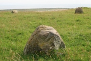
TheCaptain visited on 9th Jun 2005 - their rating: Cond: 3 Amb: 4 Access: 5 This is a nice site, up on top of a mound surrounded by forest, although it was difficult to make out what exactly remains here. It seems to be a T shaped arrangement, perhaps an east west oriented chamber with an additional northern part ? I must try to look it up somewhere. Basically, what remains are lots of stones on top of a big mound, with one or two capstones still in place.
Average ratings for this site from all visit loggers: Condition: 2.33 Ambience: 4.33 Access: 4.67
")
5km To the west of the road between Guerande to La Roche-Bernard in Brittany, near Asserac. This Dolmen is little more than an origami now, but once stood upright and had a tumulus. There is still a good atmosphere on this out of the way site. D2, 44410 Herbignac, D44, Bretagne, France Phone: 02 40 70 70 21
Opening Hours: 10:00-12:30 and 14:00-18:30 1July to 31 August
Base Mérimée (Historic Monument)
You may be viewing yesterday's version of this page. To see the most up to date information please register for a free account.
")
")
")
")
")
")
")
")
Do not use the above information on other web sites or publications without permission of the contributor.
Click here to see more info for this site
Nearby sites
Click here to view sites on an interactive map of the areaKey: Red: member's photo, Blue: 3rd party photo, Yellow: other image, Green: no photo - please go there and take one, Grey: site destroyed
Download sites to:
KML (Google Earth)
GPX (GPS waypoints)
CSV (Garmin/Navman)
CSV (Excel)
To unlock full downloads you need to sign up as a Contributory Member. Otherwise downloads are limited to 50 sites.
Turn off the page maps and other distractions
Nearby sites listing. In the following links * = Image available
3.7km E 100° Roche Aux Loups* Burial Chamber or Dolmen
4.6km ESE 109° Karlane Dolmen* Passage Grave
4.9km ESE 104° Soriniere Dolmen* Burial Chamber or Dolmen
7.3km S 185° Dolmen de la Roche au Moine Burial Chamber or Dolmen
7.9km S 183° la Butte-aux-Pierres Not Known (by us)
8.7km SE 124° Dolmen des Rochettes* Passage Grave
9.1km SW 217° La Pierre De Len Menhir* Standing Stone (Menhir)
9.3km SE 129° Monolithe du Bois-Hoël Standing Stone (Menhir)
9.5km SE 127° Menhir du Bois-Hoël Standing Stone (Menhir)
9.9km SE 128° Dolmen de la Barbière* Passage Grave
9.9km SSE 153° Butte aux Gorzeaux Burial Chamber or Dolmen
10.0km SSE 151° La Petite Butte des Roches Stone Row / Alignment
10.0km ESE 106° Le Fuseau de la Madeleine* Standing Stone (Menhir)
10.3km SSW 198° Dolmens dit les Roches de Baudin Burial Chamber or Dolmen
11.0km SSW 211° Keralio Croix Menhir* Standing Stone (Menhir)
11.6km N 357° Dolmen dit le Tombeau des Martyrs Burial Chamber or Dolmen
11.7km SSW 209° Kerdanestre Menhir Christianisé* Standing Stone (Menhir)
11.8km SE 130° Pierre-Levée (Crossac) Burial Chamber or Dolmen
11.9km SSW 207° Rocher Du Rohain* Rock Outcrop
12.0km SSW 209° Dolmens de Crugo Burial Chamber or Dolmen
12.3km SW 216° Pont de Gras* Ancient Trackway
12.4km SSE 152° dolmen du Pintré Burial Chamber or Dolmen
12.5km N 357° Dolmen dit La Chambrette Burial Chamber or Dolmen
13.2km SW 214° Kerbourg Dolmen 1* Passage Grave
13.3km SW 214° Kerbourg Dolmen 2* Burial Chamber or Dolmen
View more nearby sites and additional images


 We would like to know more about this location. Please feel free to add a brief description and any relevant information in your own language.
 Wir möchten mehr über diese Stätte erfahren. Bitte zögern Sie nicht, eine kurze Beschreibung und relevante Informationen in Deutsch hinzuzufügen.
 Nous aimerions en savoir encore un peu sur les lieux. S'il vous plaît n'hesitez pas à ajouter une courte description et tous les renseignements pertinents dans votre propre langue.
 Quisieramos informarnos un poco más de las lugares. No dude en añadir una breve descripción y otros datos relevantes en su propio idioma.