 with our Megalithic Portal iPhone app")


<< Our Photo Pages >> St Chad's Well, Tinedale Farm, Spen Brook. - Holy Well or Sacred Spring in England in Lancashire
Submitted by Sunny100 on Friday, 09 October 2015 Page Views: 3495
Springs and Holy WellsSite Name: St Chad's Well, Tinedale Farm, Spen Brook.Country: England
NOTE: This site is 2.427 km away from the location you searched for.
County: Lancashire Type: Holy Well or Sacred Spring
Nearest Town: Nelson Nearest Village: Newchurch-In-Pendle
Map Ref: SD82253845
Latitude: 53.841989N Longitude: 2.271242W
Condition:
| 5 | Perfect |
| 4 | Almost Perfect |
| 3 | Reasonable but with some damage |
| 2 | Ruined but still recognisable as an ancient site |
| 1 | Pretty much destroyed, possibly visible as crop marks |
| 0 | No data. |
| -1 | Completely destroyed |
| 5 | Superb |
| 4 | Good |
| 3 | Ordinary |
| 2 | Not Good |
| 1 | Awful |
| 0 | No data. |
| 5 | Can be driven to, probably with disabled access |
| 4 | Short walk on a footpath |
| 3 | Requiring a bit more of a walk |
| 2 | A long walk |
| 1 | In the middle of nowhere, a nightmare to find |
| 0 | No data. |
| 5 | co-ordinates taken by GPS or official recorded co-ordinates |
| 4 | co-ordinates scaled from a detailed map |
| 3 | co-ordinates scaled from a bad map |
| 2 | co-ordinates of the nearest village |
| 1 | co-ordinates of the nearest town |
| 0 | no data |
Internal Links:
External Links:
")
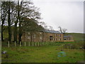
According to local legend, St Chad a 7th century northern saint, who became Archbishop of York, came to this area during his travels in the north of England. However it is more likely one of his disciples came here and dedicated the well to his master. It is though, as we already know, a pre-Christian well/spring. I am not aware of any cures happening at this well, though I'm not saying these didn't happen at some point back in the mists of time. I am told that the well water was used by local farms in the area of Tinedale, according to a gentleman who is a member of The Pendle Forest Historical Society.
The well stands close to an ancient trackway, which apparently pilgrims used in order to get to Whalley Abbey, 4 miles to the north-west. Tinedale (Tynedale) farm is "said" to be haunted, and it was associated with the Pendle Witches. It dates from 1750 but the original building was of 1600. In this area we are told 'the ancient fire festival of Beltaine used to take place', according to the late John Dixon. Sadly, it seems that St Chad's holy well has, to some extent, become largerly forgotten.
There currently appears to be no information about this well on either Historic England or Pastscape, but it is featured by The Journal of Antiquities - see their entry for St Chad’s Well, Tinedale Farm, Spen Brook, Lancashire which includes photographs and a list of referene sources for more information.
You may be viewing yesterday's version of this page. To see the most up to date information please register for a free account.
")
Do not use the above information on other web sites or publications without permission of the contributor.
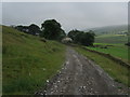
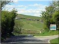
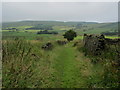
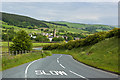
Nearby Images from Geograph Britain and Ireland:
©2014(licence)
©2017(licence)
©2014(licence)
©2014(licence)
©2009(licence)
The above images may not be of the site on this page, they are loaded from Geograph.
Please Submit an Image of this site or go out and take one for us!
Click here to see more info for this site
Nearby sites
Key: Red: member's photo, Blue: 3rd party photo, Yellow: other image, Green: no photo - please go there and take one, Grey: site destroyed
Download sites to:
KML (Google Earth)
GPX (GPS waypoints)
CSV (Garmin/Navman)
CSV (Excel)
To unlock full downloads you need to sign up as a Contributory Member. Otherwise downloads are limited to 50 sites.
Turn off the page maps and other distractions
Nearby sites listing. In the following links * = Image available
255m NNW 348° Newchurch-in-Pendle* Stone Circle (SD822387)
1.0km N 7° Jinny Well* Holy Well or Sacred Spring (SD8238039461)
4.1km WNW 286° Badger Wells Cairn Cairn (SD783396)
4.2km NE 38° Aedmer's Mound (Admergill)* Artificial Mound (SD8482941718)
4.3km NE 52° Cock Hill Standing Stone* Standing Stone (Menhir) (SD85624110)
4.4km W 281° Devil's Apronful (Pendle Hill) Cairn (SD779393)
4.5km NW 311° Pendle Hill* Round Barrow(s) (SD789414)
4.5km W 277° Lower Apronful of Stones (Pendle Hill) Cairn (SD778390)
4.5km E 81° Swinden Cross (Swinden Clough) Ancient Cross (SD86733916)
4.6km NNW 339° Pendle Hill Ringwork and Barrow Hillfort (SD806428)
4.6km NE 42° Blacko Cross (Blacko Hill) Ancient Cross (SD85414187)
4.9km W 270° Solar Wheel Year Stone (Sabden) Rock Art (SD77323846)
5.1km W 268° Coffin Stone (Sabden) Standing Stone (Menhir) (SD77173830)
5.2km ESE 120° Finn's Well (Haggate) Holy Well or Sacred Spring (SD86713582)
5.2km WSW 243° Simon's Cross (Padiham)* Ancient Cross (SD77603609)
5.7km SSE 160° The Burnley Cross* Ancient Cross (SD8423533080)
5.7km SSE 159° Shorey Well (Burnley) Holy Well or Sacred Spring (SD8424433069)
6.1km ESE 102° Catlow Well/Spring* Holy Well or Sacred Spring (SD8818137169)
6.1km ENE 66° Alkincoats Cross (Colne) Ancient Cross (SD87894094)
6.2km E 90° Castercliffe* Hillfort (SD8848738395)
6.3km W 264° Jeppe Knave's Grave* Cairn (SD75993782)
6.3km E 92° The Gib Clough Head Stone* Marker Stone (SD886382)
6.4km NW 318° Worsaw Hill Burial Mound* Round Barrow(s) (SD77934323)
6.6km ESE 118° Annot Cross (Brierfield) Ancient Cross (SD881353)
6.7km ENE 76° Emmott Cross (Colne) Ancient Cross (SD888401)
View more nearby sites and additional images


 We would like to know more about this location. Please feel free to add a brief description and any relevant information in your own language.
 Wir möchten mehr über diese Stätte erfahren. Bitte zögern Sie nicht, eine kurze Beschreibung und relevante Informationen in Deutsch hinzuzufügen.
 Nous aimerions en savoir encore un peu sur les lieux. S'il vous plaît n'hesitez pas à ajouter une courte description et tous les renseignements pertinents dans votre propre langue.
 Quisieramos informarnos un poco más de las lugares. No dude en añadir una breve descripción y otros datos relevantes en su propio idioma.