<< Our Photo Pages >> Jodrell Bank - Barrow Cemetery in England in Cheshire
Submitted by vicky on Friday, 03 January 2003 Page Views: 13350
Neolithic and Bronze AgeSite Name: Jodrell BankCountry: England
NOTE: This site is 2.557 km away from the location you searched for.
County: Cheshire Type: Barrow Cemetery
Nearest Town: Holmes Chapel Nearest Village: Lower Withington
Map Ref: SJ791704 Landranger Map Number: 118
Latitude: 53.230223N Longitude: 2.314545W
Condition:
| 5 | Perfect |
| 4 | Almost Perfect |
| 3 | Reasonable but with some damage |
| 2 | Ruined but still recognisable as an ancient site |
| 1 | Pretty much destroyed, possibly visible as crop marks |
| 0 | No data. |
| -1 | Completely destroyed |
| 5 | Superb |
| 4 | Good |
| 3 | Ordinary |
| 2 | Not Good |
| 1 | Awful |
| 0 | No data. |
| 5 | Can be driven to, probably with disabled access |
| 4 | Short walk on a footpath |
| 3 | Requiring a bit more of a walk |
| 2 | A long walk |
| 1 | In the middle of nowhere, a nightmare to find |
| 0 | No data. |
| 5 | co-ordinates taken by GPS or official recorded co-ordinates |
| 4 | co-ordinates scaled from a detailed map |
| 3 | co-ordinates scaled from a bad map |
| 2 | co-ordinates of the nearest village |
| 1 | co-ordinates of the nearest town |
| 0 | no data |
Internal Links:
External Links:
I have visited· I would like to visit
ephipps2 visited on 8th Mar 2016 - their rating: Cond: 4 Amb: 5 Access: 5 very nice area and easy to get to
pleasant walk around the arboretum

Five of the mounds were described as early as the 19th century by Ormerod: ‘In Twemlow are five of those tumuli which are of frequent occurrence at the sides of a British road, on which in this case probably the Roman one was grafted. They are nearly equidistant, and stretch along the banks of a small brook for about a quarter of a mile, the present seat of Mr Egerton Leigh standing between the second and third; the fifth is unusually large in its dimensions.’
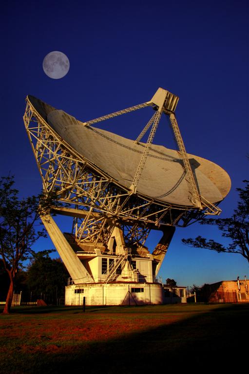
Today barrows one and two lie to the west of the Chelford to Holmes Chapel Road in the shadow of the Radio Telescope at Jodrell Bank. Both have been heavily damaged by ploughing and cremations were ploughed up from the largest mound (ii) during potato planting in 1977.
On the other side of the road in 1779, the house of Jodrell Hall was erected some 25 yards from tumulus number three and it is believed that this was done deliberately, because its shape ‘would help to break up what might otherwise have been a flat and featureless view at that time’. Apparently this was quite common, as Lees-Milne states in his book about Little Moreton Hall ‘in the sixteenth and seventeenth centuries the owners of low lying or much enclosed gardens sought outlook, either by raised boundary terraces, . . . or by mounds, as . . . in Cheshire’. Obviously by the 19th century, such distractions were not in vogue for by 1897, the mound had been completely levelled during a general landscaping of the grounds or ‘the horticolous execution’ as Kaufmann calls it!
As for barrow four, this was apparently opened in 1867 revealing an urn with accompanying cremation and marked as such on Ordnance Survey maps. The opening cannot have done too much damage to the mound for it remained as a notable landmark until 1950 when it was largely demolished to fill up a ‘fosseway’ which divided the boundary of the school fields from the outlying ones. Kaufmann noted in 1970, however, that ‘it has not completely blended with the fields around it, for, if viewed at ground level, something of its former roundness is visible on the southerly side, which repeated ploughing has failed to eliminate.' Teachers at the school kept a close eye during operations, but no other artefacts came to light.
The discovery of the urn in the 19th century was recorded in the ‘Object Name Book’ of the OS Archaeology Division in Southampton. This book kept a record of all discoveries of archaeological importance vouched for by the finder or his agent, but was sadly destroyed during bombing in 1940. The only other account comes from a book on the history of the Twemlow family: ‘The fourth was opened some years ago, a small funeral urn being found in it which soon crumbled away: it is sandy and full of rabbit burrows.’
The fifth mound, Ormerod’s ‘unusually large’ tumulus, still stands in a small plantation known as Shinglar Wood. Reputedly dug earlier this century without results and safe from the plough, it is possible that any burials may still be present. Finally investigations undertaken by the Archaeology Division of the Ordnance Survey in 1968/69 discovered a previously unrecorded barrow (vi) behind the one in Shinglar Wood. As with one and two this has suffered much under the plough and is now barely recognisable.
Access
The barrows lie at (i)SJ791704 (ii)SJ794703 (iii)SJ796701 (destroyed) (iv)SJ797699 (v)SJ798698 and (vi)SJ799697 and are in view of the radio telescope in the stretch of the A535 Holmes Chapel to Chelford road between Twemlow Green and Jodrell Bank. A footpath to one and two leads across the fields opposite Terra Nova school at SJ795702. The other three surviving barrows are located on private land in the grounds of the school and neighbouring fields.
References
G. Ormerod “The History of Cheshire”, 2nd Edition (1882)
D.M.Longley “Prehistory” in C.R.Elrington (ed) “The Victoria History of the County of Chester, volume 1, Oxford University Press (1987)
Cheshire County Sites & Monuments Record
F.R.Twemlow “The Twemlows. Their wives and their homes” (1910)
R.R.Uhthoff-Kaufman “The Archaeology of Jodrell Hall (Terra Nova), Twemlow, Cheshire”
Note: Please note only two of these barrows can be easily viewed from the nearby public footpath, the others are all located on private land in the grounds of the school.
You may be viewing yesterday's version of this page. To see the most up to date information please register for a free account.


Do not use the above information on other web sites or publications without permission of the contributor.
Click here to see more info for this site
Nearby sites
Key: Red: member's photo, Blue: 3rd party photo, Yellow: other image, Green: no photo - please go there and take one, Grey: site destroyed
Download sites to:
KML (Google Earth)
GPX (GPS waypoints)
CSV (Garmin/Navman)
CSV (Excel)
To unlock full downloads you need to sign up as a Contributory Member. Otherwise downloads are limited to 50 sites.
Turn off the page maps and other distractions
Nearby sites listing. In the following links * = Image available
282m NW 315° Axstone cross* Ancient Cross (SJ789706)
2.5km NE 38° Old Withington* Barrow Cemetery (SJ80677240)
3.4km SSE 163° St Peter (Swettenham) Ancient Cross (SJ80086718)
3.9km NNE 30° Astle Park Round Barrow(s) (SJ811738)
4.3km SSE 149° Swettenham Hall* Round Barrow(s) (SJ813667)
5.4km ENE 61° Capesthorne Hall (NW) Round Barrow(s) (SJ838730)
5.8km ENE 64° Capesthorne Hall (NE)* Round Barrow(s) (SJ843729)
5.8km ENE 68° Capesthorne Hall (SE)* Round Barrow(s) (SJ845726)
6.2km NE 55° Sodger's Hump* Round Barrow(s) (SJ842739)
6.2km SSE 161° Somerford Round Barrow Round Barrow(s) (SJ811645)
7.7km ENE 57° Birtles Hall Round Barrow(s) (SJ856745)
8.0km SSE 151° Loachbrook Farm* Long Barrow (SJ830634)
8.1km E 83° Lower Pexhill Round Barrow(s) (SJ872713)
8.4km E 79° Bearhurst Farm* Round Barrow(s) (SJ874720)
8.8km NNW 336° Nether Knutsford* Round Barrow(s) (SJ756785)
9.5km NE 47° Great Merestone Marker Stone (SJ86137677)
9.8km N 11° Lindow* Ancient Trackway (SJ810800)
9.9km ENE 76° New Farm, Henbury* Stone Circle (SJ887728)
9.9km NE 42° Armada Beacon* Round Barrow(s) (SJ858777)
10.0km NE 42° Wizard's Well* Holy Well or Sacred Spring (SJ858778)
10.0km NE 44° Golden Stone (Alderley Edge)* Standing Stone (Menhir) (SJ861776)
10.0km NE 44° Engine Vein, Alderley Edge Copper Mines* Ancient Mine, Quarry or other Industry (SJ861776)
10.0km NE 43° Wishing Well (Alderley Edge)* Holy Well or Sacred Spring (SJ860777)
10.1km NE 42° Holy Well (Alderley Edge)* Holy Well or Sacred Spring (SJ85907786)
10.1km SSW 198° Sandbach Crosses* Ancient Cross (SJ7587760825)
View more nearby sites and additional images


 We would like to know more about this location. Please feel free to add a brief description and any relevant information in your own language.
 Wir möchten mehr über diese Stätte erfahren. Bitte zögern Sie nicht, eine kurze Beschreibung und relevante Informationen in Deutsch hinzuzufügen.
 Nous aimerions en savoir encore un peu sur les lieux. S'il vous plaît n'hesitez pas à ajouter une courte description et tous les renseignements pertinents dans votre propre langue.
 Quisieramos informarnos un poco más de las lugares. No dude en añadir una breve descripción y otros datos relevantes en su propio idioma.