


<< Our Photo Pages >> Holy Trinity Church, Eccleshall - Ancient Cross in England in Staffordshire
Submitted by TimPrevett on Monday, 12 September 2005 Page Views: 7414
Early Medieval (Dark Age)Site Name: Holy Trinity Church, EccleshallCountry: England
NOTE: This site is 1.353 km away from the location you searched for.
County: Staffordshire Type: Ancient Cross
Nearest Town: Eccleshall
Map Ref: SJ82752917
Latitude: 52.859738N Longitude: 2.257646W
Condition:
| 5 | Perfect |
| 4 | Almost Perfect |
| 3 | Reasonable but with some damage |
| 2 | Ruined but still recognisable as an ancient site |
| 1 | Pretty much destroyed, possibly visible as crop marks |
| 0 | No data. |
| -1 | Completely destroyed |
| 5 | Superb |
| 4 | Good |
| 3 | Ordinary |
| 2 | Not Good |
| 1 | Awful |
| 0 | No data. |
| 5 | Can be driven to, probably with disabled access |
| 4 | Short walk on a footpath |
| 3 | Requiring a bit more of a walk |
| 2 | A long walk |
| 1 | In the middle of nowhere, a nightmare to find |
| 0 | No data. |
| 5 | co-ordinates taken by GPS or official recorded co-ordinates |
| 4 | co-ordinates scaled from a detailed map |
| 3 | co-ordinates scaled from a bad map |
| 2 | co-ordinates of the nearest village |
| 1 | co-ordinates of the nearest town |
| 0 | no data |
Internal Links:
External Links:
I have visited· I would like to visit
BrownEdger visited on 28th Jul 2012 - their rating: Cond: 3 Amb: 3 Access: 5
")
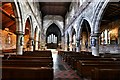
Set within the large church at the western end of Eccleshall High Street, the church, and its site, has a very long history. The oldest tokens of this history are a number of carved stone fragments, set within the fabric of the building.
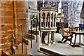
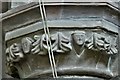
These fragments are not very well documented or interpreted. Online, the only information mentions 'a number of carved pre-Norman stones', and within the church, information on a hand held board (resembles a square table tennis racket) says there is a fragment of a cross shaft within the wall of the choir vestry, and other stones built witihn the nave. Within the choir vestry there are (in my opinion) two Saxon Cross fragments within the northern wall.
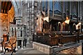
These two fragments were hard to locate; on arrival in the building I soon found a collection of carved ornate stones within the northwest corner of the tower's floor. I took some photos, but am not convinced any are Saxon. I have submitted a photo as documentation just in case.
I scouted around looking for an information leaflet, and eventually found the table tennis bat, which informed me to look in the choir vestry. Having noticed labelled light switches in the tower, I returned there and pressed the one labelled choir vestry, and thankfully one light lit up just across the tower.
The vestry was extremely dark; poorly lit indeed. Thankfully, I soon spotted not just one, but two fragments. A large piece of furniture upended obscured one, but a shift out of the way by a foot enabled a better view. Due to no interpretive material, I can not reliably comment on what is seen on the carvings.
The earliest church on the site is thought to date to the Sixth Century AD, when it was laid waste by 'heathen Mercians'; the church was again sacked, but by the Danes in 1010; it was not until 24 years after the Norman Conquest that full reparition was made. The church remains today as one of the most historically important churches in Staffordshire.
Website Here
You may be viewing yesterday's version of this page. To see the most up to date information please register for a free account.
")
")
Do not use the above information on other web sites or publications without permission of the contributor.
Nearby Images from Geograph Britain and Ireland:
©2019(licence)
©2019(licence)
©2019(licence)

©2019(licence)
©2019(licence)
The above images may not be of the site on this page, they are loaded from Geograph.
Please Submit an Image of this site or go out and take one for us!
Click here to see more info for this site
Nearby sites
Key: Red: member's photo, Blue: 3rd party photo, Yellow: other image, Green: no photo - please go there and take one, Grey: site destroyed
Download sites to:
KML (Google Earth)
GPX (GPS waypoints)
CSV (Garmin/Navman)
CSV (Excel)
To unlock full downloads you need to sign up as a Contributory Member. Otherwise downloads are limited to 50 sites.
Turn off the page maps and other distractions
Nearby sites listing. In the following links * = Image available
3.3km WNW 296° St. Catherine's Well (Sugnall)* Holy Well or Sacred Spring (SJ798306)
3.3km E 101° All Saints (Chebsey)* Ancient Cross (SJ85982856)
4.5km SSE 160° St Anne's Well (nr Lawnhead) Holy Well or Sacred Spring (SJ84262498)
6.3km NNE 18° Swynnerton bowl barrow* Barrow Cemetery (SJ8474635109)
8.7km NE 39° Bury Bank (Staffordshire)* Hillfort (SJ883359)
8.9km NNE 32° Saxon's Lowe* Round Barrow(s) (SJ8750136662)
9.3km WNW 298° Bishop's Wood Hillfort (SJ745336)
9.9km SE 143° Berry Ring* Hillfort (SJ887212)
10.6km E 86° St Rufin's Well Holy Well or Sacred Spring (SJ93372995)
10.7km NNW 338° Berth Hill* Hillfort (SJ788391)
11.4km ENE 68° Hollywood enclosure* Misc. Earthwork (SJ9338033501)
12.4km NNE 18° St Mary and All Saints (Trentham)* Ancient Cross (SJ8654640940)
12.6km SSE 155° Webb Stone* Standing Stone (Menhir) (SJ881177)
12.7km S 176° St Edith's Well (Church Eaton)* Holy Well or Sacred Spring (SJ83521653)
13.9km ESE 112° Kings Low Long Barrow (SJ9567023990)
14.5km WNW 302° The Blew Stone Standing Stone (Menhir) (SJ705370)
14.5km ESE 111° Queens Low Long Barrow (SJ9634323909)
14.6km SSW 209° Pave Lane Hillfort* Misc. Earthwork (SJ756164)
14.8km NW 305° Devil's Ring and Finger* Holed Stone (SJ7072737783)
14.8km WNW 302° The Ineaz Stone Standing Stone (Menhir) (SJ70223706)
15.6km WNW 300° Betton Standing Stone (Menhir) (SJ69193691)
15.6km NW 307° Bradling Stone* Standing Stone (Menhir) (SJ70333864)
16.4km S 188° Blymhill Marsh Holy Well or Sacred Spring (SJ80511290)
16.8km NNE 18° Stoke Minster* Ancient Cross (SJ8788745169)
16.9km N 7° Market Cross (Newcastle-under-Lyme) Ancient Cross (SJ8485745979)
View more nearby sites and additional images


 We would like to know more about this location. Please feel free to add a brief description and any relevant information in your own language.
 Wir möchten mehr über diese Stätte erfahren. Bitte zögern Sie nicht, eine kurze Beschreibung und relevante Informationen in Deutsch hinzuzufügen.
 Nous aimerions en savoir encore un peu sur les lieux. S'il vous plaît n'hesitez pas à ajouter une courte description et tous les renseignements pertinents dans votre propre langue.
 Quisieramos informarnos un poco más de las lugares. No dude en añadir una breve descripción y otros datos relevantes en su propio idioma.