


<< Text Pages >> Robins Wood Hill - Standing Stones in England in Gloucestershire
Submitted by coldrum on Tuesday, 05 January 2010 Page Views: 6791
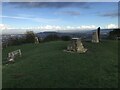
Neolithic and Bronze AgeSite Name: Robins Wood HillCountry: England
NOTE: This site is 1.672 km away from the location you searched for.
County: Gloucestershire Type: Standing Stones
Map Ref: SO841150
Latitude: 51.833382N Longitude: 2.23215W
Condition:
| 5 | Perfect |
| 4 | Almost Perfect |
| 3 | Reasonable but with some damage |
| 2 | Ruined but still recognisable as an ancient site |
| 1 | Pretty much destroyed, possibly visible as crop marks |
| 0 | No data. |
| -1 | Completely destroyed |
| 5 | Superb |
| 4 | Good |
| 3 | Ordinary |
| 2 | Not Good |
| 1 | Awful |
| 0 | No data. |
| 5 | Can be driven to, probably with disabled access |
| 4 | Short walk on a footpath |
| 3 | Requiring a bit more of a walk |
| 2 | A long walk |
| 1 | In the middle of nowhere, a nightmare to find |
| 0 | No data. |
| 5 | co-ordinates taken by GPS or official recorded co-ordinates |
| 4 | co-ordinates scaled from a detailed map |
| 3 | co-ordinates scaled from a bad map |
| 2 | co-ordinates of the nearest village |
| 1 | co-ordinates of the nearest town |
| 0 | no data |
Be the first person to rate this site - see the 'Contribute!' box in the right hand menu.
Internal Links:
External Links:
Standing Stones in Gloucestershire
From Pastscape:
"Three "immense" stones lying in a hollow on the extreme summit of Robins Wood Hill, traditionally three stones thrown by Robin Hood at the devil, were noted c.1800 by Charles Hale of Cheltenham. Lysons, who could only find one still visible in 1860, took them to be the remains of a long barrow which had been opened at some time. Charles Barnett discovered three very fine flint arrowheads at a site at the eastern end of the summit, where Canon Bazeley found burnt wood and stone, bones, two "neolithic" flint scrapers and some coarse pottery. Bazeley took it to be the remains of a barrow, although it is suggested by O'Neil and Grinsell to have been the beacon site (SO 81 NW 28). The coarse pottery found by Bazeley could be the sherds of Iron Age "A" character which Mrs Clifford records from Robins Wood Hill. The area, which is much pitted, is under grass, and there is no sign of a barrow. C Holmes Barnett presented the three flint implements found on the hill to Gloucester museum, which also has two leaf-shaped arrowheads and some flint wasters found Robins Wood Hill."
http://www.pastscape.org.uk/hob.aspx?hob_id=115301
You may be viewing yesterday's version of this page. To see the most up to date information please register for a free account.
Do not use the above information on other web sites or publications without permission of the contributor.
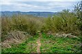
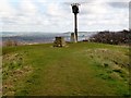
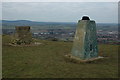
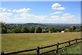
Nearby Images from Geograph Britain and Ireland:
©2023(licence)
©2013(licence)
©2011(licence)
©2011(licence)
©2021(licence)
The above images may not be of the site on this page, they are loaded from Geograph.
Please Submit an Image of this site or go out and take one for us!
Click here to see more info for this site
Nearby sites
Key: Red: member's photo, Blue: 3rd party photo, Yellow: other image, Green: no photo - please go there and take one, Grey: site destroyed
Download sites to:
KML (Google Earth)
GPX (GPS waypoints)
CSV (Garmin/Navman)
CSV (Excel)
To unlock full downloads you need to sign up as a Contributory Member. Otherwise downloads are limited to 50 sites.
Turn off the page maps and other distractions
Nearby sites listing. In the following links * = Image available
618m N 351° Well House (Gloucester)* Holy Well or Sacred Spring (SO84001561)
752m ENE 67° Red Well (Matson)* Holy Well or Sacred Spring (SO8479615289)
3.0km SSE 150° King Charles Stone* Marker Stone (SO856124)
3.4km NW 311° Hempsted Camp* Hillfort (SO81551725)
3.5km NW 311° Lady's Well (Gloucestershire)* Holy Well or Sacred Spring (SO815173)
4.0km SE 136° Painswick Beacon* Hillfort (SO869121)
4.8km ESE 113° Cranham Corner Earthworks* Misc. Earthwork (SO88501313)
5.1km ESE 103° High Brotheridge* Misc. Earthwork (SO89121381)
5.6km NE 45° Churchdown Hill Camp* Hillfort (SO881189)
5.6km S 189° Cliff Well* Holy Well or Sacred Spring (SO83240944)
5.7km E 100° Tile Well* Holy Well or Sacred Spring (SO89721395)
5.9km SSE 148° Washwell* Holy Well or Sacred Spring (SO872100)
6.1km SSE 153° St Tibby's Well* Holy Well or Sacred Spring (SO86880961)
6.3km SSW 196° Haresfield Beacon and Ring* Hillfort (SO823090)
6.4km SE 134° Holy well (Sheepscombe) Holy Well or Sacred Spring (SO887106)
6.4km S 185° Haresfield Barrow* Round Barrow(s) (SO83500862)
6.4km S 185° Haresfield Dyke Camp* Ancient Village or Settlement (SO83500862)
6.5km ENE 67° Badgeworth Round Barrow* Round Barrow(s) (SO90071750)
6.5km SSW 198° Haresfield Beacon tumulus* Round Barrow(s) (SO82030887)
6.8km SSW 192° Shortwood Barrows* Round Barrow(s) (SO82670831)
7.2km ESE 104° West Tump* Long Barrow (SO9112213241)
7.6km ESE 108° Bucks Head Round Barrow* Round Barrow(s) (SO91321260)
8.1km S 190° Randwick Cross Dyke* Misc. Earthwork (SO82690707)
8.1km ESE 112° Climperwell Round Barrows* Round Barrow(s) (SO91641196)
8.1km S 190° Randwick Barrows* Round Barrow(s) (SO82670699)
View more nearby sites and additional images


 We would like to know more about this location. Please feel free to add a brief description and any relevant information in your own language.
 Wir möchten mehr über diese Stätte erfahren. Bitte zögern Sie nicht, eine kurze Beschreibung und relevante Informationen in Deutsch hinzuzufügen.
 Nous aimerions en savoir encore un peu sur les lieux. S'il vous plaît n'hesitez pas à ajouter une courte description et tous les renseignements pertinents dans votre propre langue.
 Quisieramos informarnos un poco más de las lugares. No dude en añadir una breve descripción y otros datos relevantes en su propio idioma.