 with our Megalithic Portal iPhone app")

<< Our Photo Pages >> Attermire Scar (Settle) - Rock Art in England in Yorkshire (North)
Submitted by Anne T on Wednesday, 02 January 2019 Page Views: 1089
Rock ArtSite Name: Attermire Scar (Settle) Alternative Name: IAG649Country: England
NOTE: This site is 1.017 km away from the location you searched for.
County: Yorkshire (North) Type: Rock Art
Nearest Town: Settle Nearest Village: Langcliffe
Map Ref: SD83836464
Latitude: 54.077427N Longitude: 2.248628W
Condition:
| 5 | Perfect |
| 4 | Almost Perfect |
| 3 | Reasonable but with some damage |
| 2 | Ruined but still recognisable as an ancient site |
| 1 | Pretty much destroyed, possibly visible as crop marks |
| 0 | No data. |
| -1 | Completely destroyed |
| 5 | Superb |
| 4 | Good |
| 3 | Ordinary |
| 2 | Not Good |
| 1 | Awful |
| 0 | No data. |
| 5 | Can be driven to, probably with disabled access |
| 4 | Short walk on a footpath |
| 3 | Requiring a bit more of a walk |
| 2 | A long walk |
| 1 | In the middle of nowhere, a nightmare to find |
| 0 | No data. |
| 5 | co-ordinates taken by GPS or official recorded co-ordinates |
| 4 | co-ordinates scaled from a detailed map |
| 3 | co-ordinates scaled from a bad map |
| 2 | co-ordinates of the nearest village |
| 1 | co-ordinates of the nearest town |
| 0 | no data |
Be the first person to rate this site - see the 'Contribute!' box in the right hand menu.
Internal Links:
External Links:
 (PID:190886)")
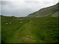
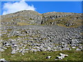
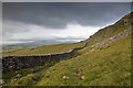
This rock art panel has been recorded in Boughey & Vickerman's "Prehistoric Rock Art of the West Riding Supplement (2018)", pages 235 to 237 inclusive. Located above Settle in North Yorkshire, this panel was first reported by Paul Brown of Darlington in 1995 and reported to Dr. Boughey in 2004. The rock is described as lying in rough pasture in a broad, raised flat valley north of Warrendale Knots, overlooking Sugar Loaf Hill to the east of Settle. The Supplement includes a map of the location of the panel, a photograph showing its context in the landscape, close ups of its motifs, plus a drawing of the panel.
The panel is described as being 62m south of the last in a set of field walls west of the public right of way and 9m west of the footpath. The rock "is a low, flat slab measuring approximately 1.15m by 1.05m by 20cms thick. It is dark blue-grey Silurian gritstone above the turf and a fine grained pinkish brown below. Its exposed upper surface "carries a profusion of what appears to be small, shallow, very worn cups".
Note: Have you seen this rock art panel? Do you have any photographs or information to add?
You may be viewing yesterday's version of this page. To see the most up to date information please register for a free account.
Do not use the above information on other web sites or publications without permission of the contributor.
Nearby Images from Geograph Britain and Ireland:
©2009(licence)
©2006(licence)
©2008(licence)
©2009(licence)
©2010(licence)
The above images may not be of the site on this page, they are loaded from Geograph.
Please Submit an Image of this site or go out and take one for us!
Click here to see more info for this site
Nearby sites
Key: Red: member's photo, Blue: 3rd party photo, Yellow: other image, Green: no photo - please go there and take one, Grey: site destroyed
Download sites to:
KML (Google Earth)
GPX (GPS waypoints)
CSV (Garmin/Navman)
CSV (Excel)
To unlock full downloads you need to sign up as a Contributory Member. Otherwise downloads are limited to 50 sites.
Turn off the page maps and other distractions
Nearby sites listing. In the following links * = Image available
361m N 355° Victoria Cave* Cave or Rock Shelter (SD838650)
442m N 355° Albert Cave Cave or Rock Shelter (SD83796508)
1.7km NNW 337° Samson's Toe (Langcliffe) Natural Stone / Erratic / Other Natural Feature (SD8317666229)
2.6km WSW 253° Bank Well* Holy Well or Sacred Spring (SD813639)
2.9km ESE 117° Rye Loaf Hill (Settle) Cairn (SD8641963309)
3.5km WNW 282° The Ebbing and Flowing Well* Holy Well or Sacred Spring (SD80396538)
3.5km WNW 296° Apronful of Stones (Giggleswick) Cairn (SD8065266193)
3.6km WNW 300° Sheep Scar Cairn (Giggleswick) Cairn (SD8067866436)
3.6km SSW 209° Cleatop Park* Stone Circle (SD82056145)
3.8km WNW 299° Sheep Scar Circle (Giggleswick) Ring Cairn (SD8051366473)
3.8km WNW 302° Feizor Thwaite Propped Stone* Rock Outcrop (SD8057466703)
4.5km E 92° Ewe Moor* Ring Cairn (SD88326445)
4.6km NW 306° Feizor Celtic Wall* Misc. Earthwork (SD8008067386)
4.9km NW 305° Feizor Thwaite (Lawkland) Ring Cairn (SD79796747)
4.9km E 95° Jorden Scar* Ancient Village or Settlement (SD88776419)
5.5km E 90° Ing Scar* Ancient Village or Settlement (SD8931964626)
5.5km E 88° Comb Scar* Ancient Village or Settlement (SD89366485)
5.8km WNW 296° Feizor (Lawkland) Standing Stone (Menhir) (SD78586718)
6.0km E 84° Torlery Edge (Malham Moor) Ancient Village or Settlement (SD8978465292)
6.7km E 100° Malham settlements and field systems* Ancient Village or Settlement (SD905635)
6.9km E 84° Seaty Hill (Malham Moor) Cairn (SD9069265390)
8.8km ENE 56° Dewbottoms (Arncliffe) Ancient Village or Settlement (SD912695)
8.9km NNE 12° Giant's Graves (Halton Gill) Cairn (SD8564873346)
9.0km NW 307° Norber Erratics Natural Stone / Erratic / Other Natural Feature (SD76597003)
9.2km WSW 242° Brown Hills Beck* Round Barrow(s) (SD75616035)
View more nearby sites and additional images


 We would like to know more about this location. Please feel free to add a brief description and any relevant information in your own language.
 Wir möchten mehr über diese Stätte erfahren. Bitte zögern Sie nicht, eine kurze Beschreibung und relevante Informationen in Deutsch hinzuzufügen.
 Nous aimerions en savoir encore un peu sur les lieux. S'il vous plaît n'hesitez pas à ajouter une courte description et tous les renseignements pertinents dans votre propre langue.
 Quisieramos informarnos un poco más de las lugares. No dude en añadir una breve descripción y otros datos relevantes en su propio idioma.