


<< Our Photo Pages >> Lune Head - Stone Circle in England in County Durham
Submitted by Bladup on Friday, 24 May 2013 Page Views: 9309
Neolithic and Bronze AgeSite Name: Lune Head Alternative Name: LuneheadCountry: England County: County Durham Type: Stone Circle
Nearest Town: Middleton-in-Teesdale / Kirby Stephen Nearest Village: Grassholme
Map Ref: NY85052039
Latitude: 54.578494N Longitude: 2.232798W
Condition:
| 5 | Perfect |
| 4 | Almost Perfect |
| 3 | Reasonable but with some damage |
| 2 | Ruined but still recognisable as an ancient site |
| 1 | Pretty much destroyed, possibly visible as crop marks |
| 0 | No data. |
| -1 | Completely destroyed |
| 5 | Superb |
| 4 | Good |
| 3 | Ordinary |
| 2 | Not Good |
| 1 | Awful |
| 0 | No data. |
| 5 | Can be driven to, probably with disabled access |
| 4 | Short walk on a footpath |
| 3 | Requiring a bit more of a walk |
| 2 | A long walk |
| 1 | In the middle of nowhere, a nightmare to find |
| 0 | No data. |
| 5 | co-ordinates taken by GPS or official recorded co-ordinates |
| 4 | co-ordinates scaled from a detailed map |
| 3 | co-ordinates scaled from a bad map |
| 2 | co-ordinates of the nearest village |
| 1 | co-ordinates of the nearest town |
| 0 | no data |
Internal Links:
External Links:
I have visited· I would like to visit
kthdsn visited on 10th Sep 2015 - their rating: Cond: 3 Amb: 5 Access: 5
")
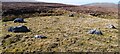
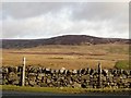
A stone circle right by the B6276, It has 8 stones in a 10 m diameter circle.
For more information see Pastscape Monument No. 915736, which says: "Prehistoric stone circle situated 650 metres south west of Lune Head Farm. The circle consists of six boulders forming an arc with two other boulders further west forming an oval 10.5 metres by 7 metres. About 9 metres north east is located an outlying stone which appears to be associated with the oval and considered part of the stone circle. Scheduled."
For the scheduling information see Historic England List ID 1020154, which adds: "The monument includes a prehistoric stone circle in Lunedale. The main part of the circle is situated about 14m from the south side of the B6276 road, and one outlying stone is situated 5m from the road. The circle consists of six boulders in an arc which, with two other boulders further west, forms an oval 10.5m by 7m. About 9m to the north east is the outlying stone which appears to be associated with the oval, and is considered to be part of the stone circle. The stones forming the oval range in size from 0.5m by 0.3m by 0.3m to 1.5m by 1m by 0.5m and 1.2m by 0.5m by 0.8m. The outlying stone measures 1.5m by 0.6m by 0.6m."
You may be viewing yesterday's version of this page. To see the most up to date information please register for a free account.
")
")
")
Do not use the above information on other web sites or publications without permission of the contributor.
Nearby Images from Geograph Britain and Ireland:
©2022(licence)
©2006(licence)
©2009(licence)
©2019(licence)
©2019(licence)
The above images may not be of the site on this page, they are loaded from Geograph.
Please Submit an Image of this site or go out and take one for us!
Click here to see more info for this site
Nearby sites
Key: Red: member's photo, Blue: 3rd party photo, Yellow: other image, Green: no photo - please go there and take one, Grey: site destroyed
Download sites to:
KML (Google Earth)
GPX (GPS waypoints)
CSV (Garmin/Navman)
CSV (Excel)
To unlock full downloads you need to sign up as a Contributory Member. Otherwise downloads are limited to 50 sites.
Turn off the page maps and other distractions
Nearby sites listing. In the following links * = Image available
6.4km SSW 192° Dyke House Hillfort (NY837141)
6.8km SSW 204° Leonard's Cragg Rock Art (NY823142)
8.6km E 92° Blake Hill 4 Rock Art (NY9372020115)
8.7km E 92° Blake Hill 3 Rock Art (NY9372320127)
8.7km E 91° Blake Hill 1 Rock Art (NY9372720135)
8.7km E 91° Blake Hill 5 Rock Art (NY9373020146)
8.7km E 92° Blake Hill 2 Rock Art (NY9373320133)
9.1km E 92° Hillgill Plantation Rock Art (NY9413920057)
9.5km ENE 69° Kirkcarrion Round Barrow(s) (NY939238)
9.6km NE 35° Bowlees, Keedholm Scar Rock Art (NY9066028210)
9.7km SE 146° Reys Cross (Stainmore) Ancient Cross (NY9047012284)
9.8km E 93° Hunderthwaite Moor 1 Rock Art (NY9485719854)
9.9km E 100° Blackton Reservoir 1* Rock Art (NY9484518555)
10.0km E 91° Howgill Grange 11 & 12 Rock Art (NY9506020240)
10.0km E 91° Howgill Grange 13* Rock Art (NY9506120244)
10.1km E 91° Howgill Grange 9* Rock Art (NY9517320235)
10.1km E 90° Howgill Grange 10* Rock Art (NY9518520280)
10.2km E 91° Howgill Grange 8* Rock Art (NY9527320193)
10.3km E 90° Howgill Grange 3* Rock Art (NY9536120410)
10.3km E 90° Howgill Grange 2* Rock Art (NY9540820366)
10.3km E 91° Howgill Grange 4* Rock Art (NY9541820248)
10.4km E 90° Howgill Grange 1.* Rock Art (NY9544620413)
10.4km E 91° Howgill Grange 7* Rock Art (NY9549820167)
10.5km E 91° Howgill Grange 6* Rock Art (NY9553220161)
10.5km E 91° Howgill Grange 5* Rock Art (NY9554320142)
View more nearby sites and additional images


 We would like to know more about this location. Please feel free to add a brief description and any relevant information in your own language.
 Wir möchten mehr über diese Stätte erfahren. Bitte zögern Sie nicht, eine kurze Beschreibung und relevante Informationen in Deutsch hinzuzufügen.
 Nous aimerions en savoir encore un peu sur les lieux. S'il vous plaît n'hesitez pas à ajouter une courte description et tous les renseignements pertinents dans votre propre langue.
 Quisieramos informarnos un poco más de las lugares. No dude en añadir una breve descripción y otros datos relevantes en su propio idioma.