


<< Our Photo Pages >> St Mary and All Saints (Trentham) - Ancient Cross in England in Staffordshire
Submitted by TimPrevett on Sunday, 20 May 2007 Page Views: 8173
Early Medieval (Dark Age)Site Name: St Mary and All Saints (Trentham)Country: England
NOTE: This site is 2.653 km away from the location you searched for.
County: Staffordshire Type: Ancient Cross
Nearest Town: Trentham
Map Ref: SJ8654640940
Latitude: 52.965651N Longitude: 2.201758W
Condition:
| 5 | Perfect |
| 4 | Almost Perfect |
| 3 | Reasonable but with some damage |
| 2 | Ruined but still recognisable as an ancient site |
| 1 | Pretty much destroyed, possibly visible as crop marks |
| 0 | No data. |
| -1 | Completely destroyed |
| 5 | Superb |
| 4 | Good |
| 3 | Ordinary |
| 2 | Not Good |
| 1 | Awful |
| 0 | No data. |
| 5 | Can be driven to, probably with disabled access |
| 4 | Short walk on a footpath |
| 3 | Requiring a bit more of a walk |
| 2 | A long walk |
| 1 | In the middle of nowhere, a nightmare to find |
| 0 | No data. |
| 5 | co-ordinates taken by GPS or official recorded co-ordinates |
| 4 | co-ordinates scaled from a detailed map |
| 3 | co-ordinates scaled from a bad map |
| 2 | co-ordinates of the nearest village |
| 1 | co-ordinates of the nearest town |
| 0 | no data |
Internal Links:
External Links:
I have visited· I would like to visit
BrownEdger would like to visit
 (PID:30041)")
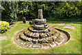
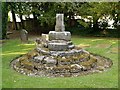
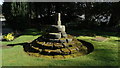
Alleged base of an Anglo Saxon Cross in the churchyard of St Mary and All Saints, Trentham. Church Website.
You may be viewing yesterday's version of this page. To see the most up to date information please register for a free account.
 (PID:30042)")
Do not use the above information on other web sites or publications without permission of the contributor.
Nearby Images from Geograph Britain and Ireland:
©2020(licence)
©2013(licence)
©2016(licence)
©2018(licence)

©2020(licence)
The above images may not be of the site on this page, they are loaded from Geograph.
Please Submit an Image of this site or go out and take one for us!
Click here to see more info for this site
Nearby sites
Key: Red: member's photo, Blue: 3rd party photo, Yellow: other image, Green: no photo - please go there and take one, Grey: site destroyed
Download sites to:
KML (Google Earth)
GPX (GPS waypoints)
CSV (Garmin/Navman)
CSV (Excel)
To unlock full downloads you need to sign up as a Contributory Member. Otherwise downloads are limited to 50 sites.
Turn off the page maps and other distractions
Nearby sites listing. In the following links * = Image available
4.4km SSE 167° Saxon's Lowe* Round Barrow(s) (SJ8750136662)
4.4km NNE 17° Stoke Minster* Ancient Cross (SJ8788745169)
5.3km NNW 341° Market Cross (Newcastle-under-Lyme) Ancient Cross (SJ8485745979)
5.3km SSE 161° Bury Bank (Staffordshire)* Hillfort (SJ883359)
6.1km SSW 197° Swynnerton bowl barrow* Barrow Cemetery (SJ8474635109)
6.1km NE 40° Berryhill Fields* Modern Stone Circle etc (SJ905456)
6.6km NNE 14° Potteries Museum & Art Gallery* Museum (SJ8815147308)
7.3km NNE 15° Hanley Stone Circle* Modern Stone Circle etc (SJ884480)
7.9km WSW 256° Berth Hill* Hillfort (SJ788391)
10.1km SE 137° Hollywood enclosure* Misc. Earthwork (SJ9338033501)
10.8km N 360° Tunstall Park* Natural Stone / Erratic / Other Natural Feature (SJ865517)
11.0km ENE 78° Cat Low* Round Barrow(s) (SJ97344320)
12.3km SSW 213° St. Catherine's Well (Sugnall)* Holy Well or Sacred Spring (SJ798306)
12.4km SSW 198° Holy Trinity Church, Eccleshall* Ancient Cross (SJ82752917)
12.4km S 182° All Saints (Chebsey)* Ancient Cross (SJ85982856)
12.9km SSE 148° St Rufin's Well Holy Well or Sacred Spring (SJ93372995)
14.1km WSW 238° Bishop's Wood Hillfort (SJ745336)
14.8km NNE 12° Gawton's Stone* Modern Stone Circle etc (SJ898554)
15.0km NNE 12° Gawton's Well* Holy Well or Sacred Spring (SJ89825555)
15.4km NNW 343° All Saints (Church Lawton)* Artificial Mound (SJ82165573)
15.8km NNW 339° Church Lawton South* Stone Circle (SJ808557)
15.9km N 5° Red Cross* Ancient Cross (SJ881568)
16.0km NNW 339° Church Lawton Barrows* Barrow Cemetery (SJ809559)
16.1km WSW 259° Devil's Ring and Finger* Holed Stone (SJ7072737783)
16.1km S 188° St Anne's Well (nr Lawnhead) Holy Well or Sacred Spring (SJ84262498)
View more nearby sites and additional images


 We would like to know more about this location. Please feel free to add a brief description and any relevant information in your own language.
 Wir möchten mehr über diese Stätte erfahren. Bitte zögern Sie nicht, eine kurze Beschreibung und relevante Informationen in Deutsch hinzuzufügen.
 Nous aimerions en savoir encore un peu sur les lieux. S'il vous plaît n'hesitez pas à ajouter une courte description et tous les renseignements pertinents dans votre propre langue.
 Quisieramos informarnos un poco más de las lugares. No dude en añadir una breve descripción y otros datos relevantes en su propio idioma.