

<< Text Pages >> Menhir de la Coudraie - Standing Stone (Menhir) in France in Bretagne:Morbihan (56)
Submitted by holger_rix on Saturday, 18 June 2016 Page Views: 842
Neolithic and Bronze AgeSite Name: Menhir de la CoudraieCountry: France
NOTE: This site is 5.834 km away from the location you searched for.
Département: Bretagne:Morbihan (56) Type: Standing Stone (Menhir)
Nearest Town: Vannes Nearest Village: Saint-Congard
Latitude: 47.741909N Longitude: 2.285048W
Condition:
| 5 | Perfect |
| 4 | Almost Perfect |
| 3 | Reasonable but with some damage |
| 2 | Ruined but still recognisable as an ancient site |
| 1 | Pretty much destroyed, possibly visible as crop marks |
| 0 | No data. |
| -1 | Completely destroyed |
| 5 | Superb |
| 4 | Good |
| 3 | Ordinary |
| 2 | Not Good |
| 1 | Awful |
| 0 | No data. |
| 5 | Can be driven to, probably with disabled access |
| 4 | Short walk on a footpath |
| 3 | Requiring a bit more of a walk |
| 2 | A long walk |
| 1 | In the middle of nowhere, a nightmare to find |
| 0 | No data. |
| 5 | co-ordinates taken by GPS or official recorded co-ordinates |
| 4 | co-ordinates scaled from a detailed map |
| 3 | co-ordinates scaled from a bad map |
| 2 | co-ordinates of the nearest village |
| 1 | co-ordinates of the nearest town |
| 0 | no data |
Be the first person to rate this site - see the 'Contribute!' box in the right hand menu.
Internal Links:
External Links:
Standing Stone (Menhir) in Bretagne:Morbihan (56)
Halage Canal Nantes à Brest, Saint-Congard, Vannes, Morbihan, Brittany
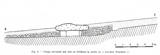
Source: T4T35
Wikipedia article
Liste des sites mégalithiques du Morbihan
You may be viewing yesterday's version of this page. To see the most up to date information please register for a free account.
Do not use the above information on other web sites or publications without permission of the contributor.
Nearby Images from Flickr


The above images may not be of the site on this page, but were taken nearby. They are loaded from Flickr so please click on them for image credits.
Click here to see more info for this site
Nearby sites
Click here to view sites on an interactive map of the areaKey: Red: member's photo, Blue: 3rd party photo, Yellow: other image, Green: no photo - please go there and take one, Grey: site destroyed
Download sites to:
KML (Google Earth)
GPX (GPS waypoints)
CSV (Garmin/Navman)
CSV (Excel)
To unlock full downloads you need to sign up as a Contributory Member. Otherwise downloads are limited to 50 sites.
Turn off the page maps and other distractions
Nearby sites listing. In the following links * = Image available
1.7km WNW 285° Allée Couverte du Mont-Hersé Passage Grave
2.1km W 279° Allée Couverte du Carhon Passage Grave
3.2km SW 224° Dolmen-des-Follets* Burial Chamber or Dolmen
3.3km WSW 252° Bonnet Rouge menhirs* Standing Stones
3.4km WNW 284° Dolmen de Brignac Burial Chamber or Dolmen
3.5km W 260° Pierre au Berceau 2 Burial Chamber or Dolmen
3.6km W 269° Menhir de Misny Standing Stone (Menhir)
3.8km NNW 330° Allée Couverte du Commun de Tréménan Passage Grave
3.9km W 261° Pierre au Berceau 1 Burial Chamber or Dolmen
4.0km NE 36° Cupules de la Croix de Saint-Léonard Rock Art
4.8km WSW 254° La Pierre Longue (Pluherlin)* Standing Stone (Menhir)
5.0km SSW 207° Parc de Préhistoire de Bretagne* Museum
5.1km NNW 338° Allée couverte de Chateau de Beaumont Passage Grave
5.1km NNW 337° Dolmen del Courtil des Fées Burial Chamber or Dolmen
5.1km NNW 338° Menhir de Beaumont Standing Stone (Menhir)
6.6km W 279° Pierre aux Bassins (Pleucadeuc) Rock Art
6.7km NNW 337° Menhir du Cimetière* Standing Stone (Menhir)
7.7km ENE 58° Allée couverte du Sigré* Passage Grave
7.7km NNW 336° Alignement d'Evas Stone Row / Alignment
7.8km N 349° Menhir de Digoit Standing Stone (Menhir)
8.3km WNW 284° Menhir des Hautes-Landes* Standing Stone (Menhir)
8.5km WSW 258° Menhir des Gardes Standing Stone (Menhir)
8.5km WSW 257° Dolmen de Trébrun Burial Chamber or Dolmen
10.7km W 280° Ranion sud menhir* Standing Stone (Menhir)
11.1km NW 310° Bois-Solon Menhirs Standing Stones
View more nearby sites and additional images


 We would like to know more about this location. Please feel free to add a brief description and any relevant information in your own language.
 Wir möchten mehr über diese Stätte erfahren. Bitte zögern Sie nicht, eine kurze Beschreibung und relevante Informationen in Deutsch hinzuzufügen.
 Nous aimerions en savoir encore un peu sur les lieux. S'il vous plaît n'hesitez pas à ajouter une courte description et tous les renseignements pertinents dans votre propre langue.
 Quisieramos informarnos un poco más de las lugares. No dude en añadir una breve descripción y otros datos relevantes en su propio idioma.