


<< Our Photo Pages >> Nine Standards Rigg - Long Barrow in England in Cumbria
Submitted by Andy B on Sunday, 29 August 2010 Page Views: 12445
Neolithic and Bronze AgeSite Name: Nine Standards Rigg Alternative Name: Hartley FellCountry: England County: Cumbria Type: Long Barrow
Nearest Town: Kirkby Stephen
Map Ref: NY82400611
Latitude: 54.450077N Longitude: 2.272937W
Condition:
| 5 | Perfect |
| 4 | Almost Perfect |
| 3 | Reasonable but with some damage |
| 2 | Ruined but still recognisable as an ancient site |
| 1 | Pretty much destroyed, possibly visible as crop marks |
| 0 | No data. |
| -1 | Completely destroyed |
| 5 | Superb |
| 4 | Good |
| 3 | Ordinary |
| 2 | Not Good |
| 1 | Awful |
| 0 | No data. |
| 5 | Can be driven to, probably with disabled access |
| 4 | Short walk on a footpath |
| 3 | Requiring a bit more of a walk |
| 2 | A long walk |
| 1 | In the middle of nowhere, a nightmare to find |
| 0 | No data. |
| 5 | co-ordinates taken by GPS or official recorded co-ordinates |
| 4 | co-ordinates scaled from a detailed map |
| 3 | co-ordinates scaled from a bad map |
| 2 | co-ordinates of the nearest village |
| 1 | co-ordinates of the nearest town |
| 0 | no data |
Internal Links:
External Links:
I have visited· I would like to visit
Andy B has visited here
")
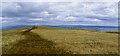
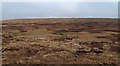
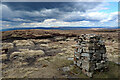
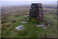
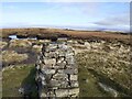
The name is derived from a group of cairns, the Nine Standards, located near the summit.
The Nine Standards themselves, some of which were originally more than 4 metres high, are on the line of the Coast to Coast Walk between Kirkby Stephen and Keld, and are just to the north of the fell's summit. Situated at a height of 650 m, their original purpose is uncertain but one possibility that they marked the boundary between Westmorland and Swaledale.
In his book, Nine Standards: Ancient Cairns or Modern Folly? Stephen Walker speculates that they could be prehistoric, with a barrow beneath them.
Note: As seen on BBC Secret Britain, are these Ancient Cairns or a Modern Folly?
You may be viewing yesterday's version of this page. To see the most up to date information please register for a free account.
")
")
")
")
Do not use the above information on other web sites or publications without permission of the contributor.
Nearby Images from Geograph Britain and Ireland:
©2022(licence)
©2011(licence)
©2021(licence)
©2014(licence)
©2022(licence)
The above images may not be of the site on this page, they are loaded from Geograph.
Please Submit an Image of this site or go out and take one for us!
Click here to see more info for this site
Nearby sites
Key: Red: member's photo, Blue: 3rd party photo, Yellow: other image, Green: no photo - please go there and take one, Grey: site destroyed
Download sites to:
KML (Google Earth)
GPX (GPS waypoints)
CSV (Garmin/Navman)
CSV (Excel)
To unlock full downloads you need to sign up as a Contributory Member. Otherwise downloads are limited to 50 sites.
Turn off the page maps and other distractions
Nearby sites listing. In the following links * = Image available
290m N 360° Nine Standards* Cairn (NY824064)
5.0km WSW 250° Round Hill, Birkett Common Round Cairns* Round Cairn (NY7764004444)
5.5km WNW 287° The Loki Stone* Early Christian Sculptured Stone (NY77130774)
5.8km WNW 286° Croglam Castle Ancient Village or Settlement (NY768077)
8.1km N 359° Leonard's Cragg Rock Art (NY823142)
8.1km N 9° Dyke House Hillfort (NY837141)
8.6km W 264° Rasett Hill* Round Cairn (NY73780531)
10.1km NE 52° Reys Cross (Stainmore) Ancient Cross (NY9047012284)
10.5km W 271° Crosby Garrett Ancient Village or Settlement (NY719064)
10.9km WSW 237° Fell End Stone Circle* Modern Stone Circle etc (NY73160023)
11.6km W 266° St. Helen's Well (Newbiggin-on-Lune)* Holy Well or Sacred Spring (NY7079905268)
11.8km W 273° Bent's Hill Round Cairn* Round Cairn (NY7060206780)
12.4km SE 135° Muker Stone Circle (SD911973)
12.6km NW 323° Moor Beck Marker Stone* Marker Stone (NY7490616292)
12.8km SW 231° Uldale, Black Moss Marker Stone (SD7237398039)
12.9km E 83° Mudbeck 2 (Arkengarthdale Moor) Rock Art (NY9527407728)
13.3km E 83° Mudbeck Stone Circle (NY9562607618)
13.3km WSW 242° Adamthwaite Standing Stone* Marker Stone (SD7062899794)
13.4km W 280° Little Asby Scar Round Cairn* Round Cairn (NY6920808493)
13.8km SW 230° Rawthey Cave Cave or Rock Shelter (SD718973)
13.8km SW 233° Rawthey Bridge (Fell End)* Stone Circle (SD714978)
14.0km W 274° Raiset Pike* Long Barrow (NY68400725)
14.5km W 279° Howes Well ring cairn* Ring Cairn (NY6804908373)
14.5km N 10° Lune Head* Stone Circle (NY85052039)
14.6km SW 231° Rawthey Bridge Stone Circle (SD710970)
View more nearby sites and additional images


 We would like to know more about this location. Please feel free to add a brief description and any relevant information in your own language.
 Wir möchten mehr über diese Stätte erfahren. Bitte zögern Sie nicht, eine kurze Beschreibung und relevante Informationen in Deutsch hinzuzufügen.
 Nous aimerions en savoir encore un peu sur les lieux. S'il vous plaît n'hesitez pas à ajouter une courte description et tous les renseignements pertinents dans votre propre langue.
 Quisieramos informarnos un poco más de las lugares. No dude en añadir una breve descripción y otros datos relevantes en su propio idioma.