


<< Text Pages >> Shorey Well (Burnley) - Holy Well or Sacred Spring in England in Lancashire
Submitted by Anne T on Monday, 21 January 2019 Page Views: 1156
Springs and Holy WellsSite Name: Shorey Well (Burnley) Alternative Name: St Audrey's Well; Whitaker's Well; Whittaker's WellCountry: England
NOTE: This site is 1.798 km away from the location you searched for.
County: Lancashire Type: Holy Well or Sacred Spring
Nearest Town: Burnley
Map Ref: SD8424433069
Latitude: 53.793690N Longitude: 2.240661W
Condition:
| 5 | Perfect |
| 4 | Almost Perfect |
| 3 | Reasonable but with some damage |
| 2 | Ruined but still recognisable as an ancient site |
| 1 | Pretty much destroyed, possibly visible as crop marks |
| 0 | No data. |
| -1 | Completely destroyed |
| 5 | Superb |
| 4 | Good |
| 3 | Ordinary |
| 2 | Not Good |
| 1 | Awful |
| 0 | No data. |
| 5 | Can be driven to, probably with disabled access |
| 4 | Short walk on a footpath |
| 3 | Requiring a bit more of a walk |
| 2 | A long walk |
| 1 | In the middle of nowhere, a nightmare to find |
| 0 | No data. |
| 5 | co-ordinates taken by GPS or official recorded co-ordinates |
| 4 | co-ordinates scaled from a detailed map |
| 3 | co-ordinates scaled from a bad map |
| 2 | co-ordinates of the nearest village |
| 1 | co-ordinates of the nearest town |
| 0 | no data |
Be the first person to rate this site - see the 'Contribute!' box in the right hand menu.
Internal Links:
External Links:
Holy Well or Sacred Spring in Lancashire
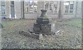
The Shorey Well is recorded as Pastscape Monument No. 890197, which tells us the well measures 1.1m high and 1.8m long. It has a cupboard-like cavity of stonework and is reputed to have been the sole water supply when Burnley was a village clustering about the parish church, when it was known as St. Peter's hamlet.
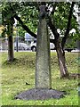
The well is scheduled as Historic England List ID 1022619 which adds: "The well to which it belonged was on the east side of the River Brun, opposite Dawson Square; the structure there was renewed in 1736, and this portion was removed to this site probably c1881". HE adds this well forms a group with the Paulinus Cross and the base of the former market cross.
The well is also featured in The Northern Antiquarian's entry for the Shorey Well, Burnley, Lancashire, which includes a 1906 photograph of the well, together with a brief 'archaeology and history'.
The Journal of Antiquities also includes a mention of this well, together with a photograph, on their page for The Burnley Cross, Burnley, Lancashire - scroll down towards the bottom of this webpage, which includes a photograph.
Note: Have you visited this site? Do you have any photographs or information to add?
You may be viewing yesterday's version of this page. To see the most up to date information please register for a free account.
Do not use the above information on other web sites or publications without permission of the contributor.
Nearby Images from Geograph Britain and Ireland:
©2021(licence)
©2021(licence)
©2009(licence)
©2008(licence)
©2006(licence)
The above images may not be of the site on this page, they are loaded from Geograph.
Please Submit an Image of this site or go out and take one for us!
Click here to see more info for this site
Nearby sites
Key: Red: member's photo, Blue: 3rd party photo, Yellow: other image, Green: no photo - please go there and take one, Grey: site destroyed
Download sites to:
KML (Google Earth)
GPX (GPS waypoints)
CSV (Garmin/Navman)
CSV (Excel)
To unlock full downloads you need to sign up as a Contributory Member. Otherwise downloads are limited to 50 sites.
Turn off the page maps and other distractions
Nearby sites listing. In the following links * = Image available
14m NW 321° The Burnley Cross* Ancient Cross (SD8423533080)
2.6km SSE 157° Foldys Cross (Towneley) Ancient Cross (SD85253065)
3.1km SE 130° Cliviger Laithe (Worsthorne) Cairn (SD866311)
3.7km NE 42° Finn's Well (Haggate) Holy Well or Sacred Spring (SD86713582)
4.0km ENE 67° Calf Hey Well (Briercliffe) Holy Well or Sacred Spring (SD8794334622)
4.1km SE 134° Cliviger Law (Mereclough) Cairn (SD872302)
4.2km ENE 76° Nogworth Cross (Briercliffe) Ancient Cross (SD8833934086)
4.2km E 94° Worsthorne Moor* Stone Circle (SD8845932764)
4.4km E 91° Ring Stones (Worsthorne) Stone Circle (SD8864933006)
4.4km ENE 60° Annot Cross (Brierfield) Ancient Cross (SD881353)
4.7km SE 130° Stump Cross (Mereclough)* Standing Stone (Menhir) (SD8781130029)
4.7km E 79° Beth Cross (Holden Clough) Ancient Cross (SD88863395)
4.8km E 82° Twist Hill Barrow* Round Barrow(s) (SD88983370)
4.8km SE 127° Mosley Height* Stone Circle (SD881302)
4.9km ENE 77° Beadle Hill (Extwistle) Misc. Earthwork (SD8901834112)
4.9km E 95° Hameldon Pasture (II)* Cairn (SD8911832597)
4.9km E 95° Hameldon Pasture (I)* Round Barrow(s) (SD8914232622)
5.0km ENE 78° Bonfire Hill III* Round Barrow(s) (SD891341)
5.0km ENE 78° Bonfire Hill II* Round Barrow(s) (SD892341)
5.3km ENE 76° Bonfire Hill 1* Cairn (SD894343)
5.3km ENE 59° Burwain's Farm Stone Circle (SD888358)
5.7km SE 143° St John the Divine (Holme-in-Cliviger) Ancient Cross (SD8763428520)
5.7km NE 44° Catlow Well/Spring* Holy Well or Sacred Spring (SD8818137169)
5.7km NNW 340° St Chad's Well, Tinedale Farm, Spen Brook.* Holy Well or Sacred Spring (SD82253845)
5.8km E 83° Delf Hill* Stone Circle (SD9006433732)
View more nearby sites and additional images


 We would like to know more about this location. Please feel free to add a brief description and any relevant information in your own language.
 Wir möchten mehr über diese Stätte erfahren. Bitte zögern Sie nicht, eine kurze Beschreibung und relevante Informationen in Deutsch hinzuzufügen.
 Nous aimerions en savoir encore un peu sur les lieux. S'il vous plaît n'hesitez pas à ajouter une courte description et tous les renseignements pertinents dans votre propre langue.
 Quisieramos informarnos un poco más de las lugares. No dude en añadir una breve descripción y otros datos relevantes en su propio idioma.