


<< Text Pages >> Pimperne Maze - Turf Maze in England in Dorset
Submitted by HOLYWELL on Tuesday, 01 February 2011 Page Views: 6822
Multi-periodSite Name: Pimperne MazeCountry: England
NOTE: This site is 0.745 km away from the location you searched for.
County: Dorset Type: Turf Maze
Nearest Town: Blandford Forum Nearest Village: Pimperne
Map Ref: ST892074
Latitude: 50.866002N Longitude: 2.154836W
Condition:
| 5 | Perfect |
| 4 | Almost Perfect |
| 3 | Reasonable but with some damage |
| 2 | Ruined but still recognisable as an ancient site |
| 1 | Pretty much destroyed, possibly visible as crop marks |
| 0 | No data. |
| -1 | Completely destroyed |
| 5 | Superb |
| 4 | Good |
| 3 | Ordinary |
| 2 | Not Good |
| 1 | Awful |
| 0 | No data. |
| 5 | Can be driven to, probably with disabled access |
| 4 | Short walk on a footpath |
| 3 | Requiring a bit more of a walk |
| 2 | A long walk |
| 1 | In the middle of nowhere, a nightmare to find |
| 0 | No data. |
| 5 | co-ordinates taken by GPS or official recorded co-ordinates |
| 4 | co-ordinates scaled from a detailed map |
| 3 | co-ordinates scaled from a bad map |
| 2 | co-ordinates of the nearest village |
| 1 | co-ordinates of the nearest town |
| 0 | no data |
Internal Links:
External Links:
Turf Maze in Dorset
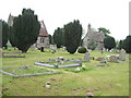
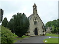
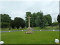
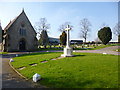
This large maze, covering nearly an acre with a roughly triangular design which had ridges half a metre high. It was once stood associated with a barrow on the corner of the Higher Shaftesbury Lane, where there is a cemetery now. It was destroyed in 1730.
You may be viewing yesterday's version of this page. To see the most up to date information please register for a free account.
Do not use the above information on other web sites or publications without permission of the contributor.
Nearby Images from Geograph Britain and Ireland:
©2006(licence)
©2013(licence)
©2013(licence)
©2013(licence)
©2020(licence)
The above images may not be of the site on this page, they are loaded from Geograph.
Please Submit an Image of this site or go out and take one for us!
Click here to see more info for this site
Nearby sites
Key: Red: member's photo, Blue: 3rd party photo, Yellow: other image, Green: no photo - please go there and take one, Grey: site destroyed
Download sites to:
KML (Google Earth)
GPX (GPS waypoints)
CSV (Garmin/Navman)
CSV (Excel)
To unlock full downloads you need to sign up as a Contributory Member. Otherwise downloads are limited to 50 sites.
Turn off the page maps and other distractions
Nearby sites listing. In the following links * = Image available
1.8km SSW 206° Blandford Forum Stones* Standing Stones (ST884058)
2.4km ENE 66° Blandford Race Down Round Barrow(s) (ST91360836)
2.5km ESE 107° Tarrant Rawston Long Barrow* Long Barrow (ST91550667)
3.0km ESE 117° Buzbury Rings* Ancient Village or Settlement (ST919060)
4.0km NE 39° Pimperne Long Barrow* Long Barrow (ST917105)
4.8km NW 312° Hod Hill* Hillfort (ST856106)
5.6km NW 317° Stepleton Enclosure Causewayed Enclosure (ST8540311526)
5.8km SSE 158° Spettisbury Rings* Hillfort (ST914020)
6.3km NW 317° Hambledon Hill long barrow* Long Barrow (ST84891205)
6.4km NW 316° Southern cross-dyke* Misc. Earthwork (ST84791202)
6.5km NW 317° Hambledon Hill enclosure* Causewayed Enclosure (ST848122)
6.5km NW 320° Eastern Cross Dyke Misc. Earthwork (ST85051242)
6.7km SW 218° Combs Ditch Ancient Village or Settlement (ST851021)
6.9km SE 128° Straw Barrow Round Barrow(s) (ST94660312)
7.0km NW 318° Hambledon Hill long barrow Long Barrow (ST84511265)
7.1km NW 318° Hambledon Hill hillfort* Hillfort (ST84511270)
7.1km SE 144° Shapwick Round Barrow(s) (ST9336301635)
7.3km NW 319° Hambledon Hillfort Spur Enclosure Misc. Earthwork (ST84351290)
7.6km NE 36° Chettle Long Barrow* Long Barrow (ST937135)
7.9km NW 320° Hambledon Farm Stone Circle* Modern Stone Circle etc (ST8420413467)
8.0km NE 47° Chettle House* Long Barrow (ST9506612803)
8.0km SE 124° Badbury Barrow Barrow Cemetery (ST958029)
8.4km W 278° Ringmoor Settlement* Ancient Village or Settlement (ST809086)
8.4km ESE 121° Badbury Rings* Hillfort (ST96400299)
9.0km NNE 25° Caesar's Camp (Dorset)* Hillfort (ST930156)
View more nearby sites and additional images


 We would like to know more about this location. Please feel free to add a brief description and any relevant information in your own language.
 Wir möchten mehr über diese Stätte erfahren. Bitte zögern Sie nicht, eine kurze Beschreibung und relevante Informationen in Deutsch hinzuzufügen.
 Nous aimerions en savoir encore un peu sur les lieux. S'il vous plaît n'hesitez pas à ajouter une courte description et tous les renseignements pertinents dans votre propre langue.
 Quisieramos informarnos un poco más de las lugares. No dude en añadir una breve descripción y otros datos relevantes en su propio idioma.