


<< Our Photo Pages >> Seal Well (Hexham) - Holy Well or Sacred Spring in England in Northumberland
Submitted by Anne T on Thursday, 05 September 2019 Page Views: 2262
Springs and Holy WellsSite Name: Seal Well (Hexham) Alternative Name: Sele Well (Hexham)Country: England County: Northumberland Type: Holy Well or Sacred Spring
Nearest Town: Hexham
Map Ref: NY93246421
Latitude: 54.972459N Longitude: 2.107133W
Condition:
| 5 | Perfect |
| 4 | Almost Perfect |
| 3 | Reasonable but with some damage |
| 2 | Ruined but still recognisable as an ancient site |
| 1 | Pretty much destroyed, possibly visible as crop marks |
| 0 | No data. |
| -1 | Completely destroyed |
| 5 | Superb |
| 4 | Good |
| 3 | Ordinary |
| 2 | Not Good |
| 1 | Awful |
| 0 | No data. |
| 5 | Can be driven to, probably with disabled access |
| 4 | Short walk on a footpath |
| 3 | Requiring a bit more of a walk |
| 2 | A long walk |
| 1 | In the middle of nowhere, a nightmare to find |
| 0 | No data. |
| 5 | co-ordinates taken by GPS or official recorded co-ordinates |
| 4 | co-ordinates scaled from a detailed map |
| 3 | co-ordinates scaled from a bad map |
| 2 | co-ordinates of the nearest village |
| 1 | co-ordinates of the nearest town |
| 0 | no data |
Internal Links:
External Links:
I have visited· I would like to visit
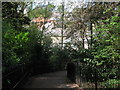
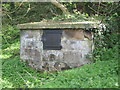
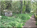
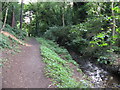
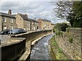
Anne T visited on 3rd Sep 2019 - their rating: Cond: 2 Amb: 3 Access: 4 The Seal/Sele Well, Hexham: Walking into a part of Hexham we’d never been to before, we came across the Cock Shaw Burn which runs SW-NE along the western side of the Sele. We passed a gloriously ornate drinking fountain (now dry) next to the southern side of the school, right next to the footpath. At the western side of the Sele, a footpath turned to our right, downhill. At the bottom, a footbridge crosses the Cock Shaw Burn. We turned left along the footpath running along its southern side, and about 30m along, spotted a stone and cast iron structure behind the nettles.
We managed to trample down the nettles to get a closer look. I unhooked some of the ivy from the ring in the indentation in the middle of the well to get a closer look at the underlying well structure. No-one has seen this well in some time, but it was very nice to find it.
This is a really old part of Hexham, and one we’d never explored before. Nearby, a second burn (presumably the Cowgarth Burn) runs along a cobbled road through Tanner’s Yard.
We went onto find, and photograph, Wine's Well (to the west of Hexham) and the Park Well (to the east). These are recorded as just 'wells' on Pastscape, and have no holy or healing characteristics that I'm aware of.
 (PID:202125)")
This well has not been visited for some time, and looked to have been dry for some considerable time when we found it. Recorded as Pastscape Monument No. 18671, it was described in 1956 and 1966 as being "a spring enclosed in a modern stone building with the water issuing from two iron pipes. No evidence for dating".
The well is mentioned in Binnall and Hope's "Holy Wells of Northumberland and Durham" paper of 1941 (page 33), which describes the renaming of the two burns which run through Hexham (Cockshawburn, which used to be called the Hextol and the Cowgarthburn, which was the Halgut". Binnall and Hope say: "Water of much superior quality (to that of the pants in the town) is procured from a well on the west side of the Seal (source: Wright, History of Hexham, 1823, pp 11, 114)". I understand the well may also be mentioned in the "Black Book of Hexham Priory", dated 1479, which I'm currently trying to check on.
The well can be found by walking westwards along the path through the Seal (Sele) from Hexham Abbey, alongside the southern side of the school. At the western end of the school, the path divides. Take the path to your right which goes downhill to the Cockshaw Burn. Just before the small bridge over the burn, take the path to your left. The well is about 50m along the path, at the bottom of a heavily wooded bank, to your left hand side.
You may be viewing yesterday's version of this page. To see the most up to date information please register for a free account.
 (PID:202126)")
 (PID:202124)")
Do not use the above information on other web sites or publications without permission of the contributor.
Nearby Images from Geograph Britain and Ireland:
©2010(licence)
©2010(licence)
©2010(licence)
©2007(licence)
©2024(licence)
The above images may not be of the site on this page, they are loaded from Geograph.
Please Submit an Image of this site or go out and take one for us!
Click here to see more info for this site
Nearby sites
Key: Red: member's photo, Blue: 3rd party photo, Yellow: other image, Green: no photo - please go there and take one, Grey: site destroyed
Download sites to:
KML (Google Earth)
GPX (GPS waypoints)
CSV (Garmin/Navman)
CSV (Excel)
To unlock full downloads you need to sign up as a Contributory Member. Otherwise downloads are limited to 50 sites.
Turn off the page maps and other distractions
Nearby sites listing. In the following links * = Image available
295m ESE 114° Hexham Abbey* Ancient Cross (NY93516409)
915m ESE 107° Eastern Sanctuary Cross (Hexham)* Ancient Cross (NY9411663937)
1.4km SE 125° Shield Croft Farm, Hexham a, b & c Rock Art (NY9440063400)
1.5km N 2° St John Lee Church (Oakwood Stone)* Rock Art (NY9329865718)
3.0km NW 321° St Michael's Church (Warden)* Ancient Cross (NY9136166492)
3.0km NNW 342° Acomb Sanctuary Cross* Ancient Cross (NY9232067077)
3.1km E 96° Dilston cists* Cist (NY963639)
4.6km NW 322° Warden Hill Hillfort* Hillfort (NY9042367863)
4.6km NNW 333° Homers Lane (Warden)* Rock Art (NY9112368334)
4.8km N 1° Crag House Cross Base* Ancient Cross (NY9333869021)
4.9km NNW 332° Homers Lane Cross (Warden)* Ancient Cross (NY9097868555)
4.9km NNW 345° Wall Crags Settlement* Ancient Village or Settlement (NY920690)
5.0km E 82° Hadrian's Wall (Coria)* Stone Fort or Dun (NY9818064904)
5.1km E 83° Corbridge Rock Art Panel* Rock Art (NY9826764830)
5.4km N 5° St Oswald in Lee (Heavenfield)* Ancient Cross (NY9369669560)
5.5km NW 314° Fairy Stone (Fourstones) Natural Stone / Erratic / Other Natural Feature (NY893680)
5.6km E 84° Old Prior Manor House Well (Corbridge)* Holy Well or Sacred Spring (NY9879164783)
5.6km E 88° St Andrew's Church (Corbridge)* Ancient Cross (NY98836443)
5.6km E 88° Corbridge Crosses* Ancient Cross (NY9885564411)
5.7km WSW 245° The Hanging Stone (Haydon)* Standing Stone (Menhir) (NY8810161779)
5.7km N 349° Hadrian's Wall (Brunton Turret)* Misc. Earthwork (NY9213469846)
6.0km E 88° Old Viney Museum (Corbridge)* Sculptured Stone (NY99226445)
6.0km SW 223° Jingling Gate* Ancient Village or Settlement (NY89145984)
6.1km NNW 343° Hadrian's Wall (Chesters Bridge Abutment)* Misc. Earthwork (NY9141970072)
6.1km NNW 343° Chesters Roman Site b* Rock Art (NY9142070076)
View more nearby sites and additional images


 We would like to know more about this location. Please feel free to add a brief description and any relevant information in your own language.
 Wir möchten mehr über diese Stätte erfahren. Bitte zögern Sie nicht, eine kurze Beschreibung und relevante Informationen in Deutsch hinzuzufügen.
 Nous aimerions en savoir encore un peu sur les lieux. S'il vous plaît n'hesitez pas à ajouter une courte description et tous les renseignements pertinents dans votre propre langue.
 Quisieramos informarnos un poco más de las lugares. No dude en añadir una breve descripción y otros datos relevantes en su propio idioma.