Featured: Current Archaeology Book of the Year 2019!

Current Archaeology Book of the Year 2019!

The Illustrated Encyclopedia of Native American Indian Mounds

The Illustrated Encyclopedia of Native American Indian Mounds

Who's Online

There are currently, 277 guests and 3 members online.

You are a guest. To join in, please register for free by clicking here

Sponsors

<< Our Photo Pages >> Battlesbury Camp - Hillfort in England in Wiltshire

Submitted by JimChampion on Wednesday, 30 January 2013  Page Views: 26413

Iron Age and Later PrehistorySite Name: Battlesbury Camp
Country: England County: Wiltshire Type: Hillfort
Nearest Town: Warminster
Map Ref: ST898456  Landranger Map Number: 184
Latitude: 51.209513N  Longitude: 2.147398W
Condition:
5Perfect
4Almost Perfect
3Reasonable but with some damage
2Ruined but still recognisable as an ancient site
1Pretty much destroyed, possibly visible as crop marks
0No data.
-1Completely destroyed
4 Ambience:
5Superb
4Good
3Ordinary
2Not Good
1Awful
0No data.
4 Access:
5Can be driven to, probably with disabled access
4Short walk on a footpath
3Requiring a bit more of a walk
2A long walk
1In the middle of nowhere, a nightmare to find
0No data.
3 Accuracy:
5co-ordinates taken by GPS or official recorded co-ordinates
4co-ordinates scaled from a detailed map
3co-ordinates scaled from a bad map
2co-ordinates of the nearest village
1co-ordinates of the nearest town
0no data
5

Internal Links:
External Links:

I have visited· I would like to visit

achiersnakes visited on 14th Jun 2016 - their rating: Cond: 3 Amb: 5 Access: 4 Site is amazing and very isolated. Short walk on foot from road near the army training ground. Live exercises take place on the Camp - military - but do not be discouraged as the view from the top is fantastic. Great walk around and visible henge surrounding the centre. Worth a visit!

lunaman visited on 22nd Feb 2014 - their rating: Cond: 3 Amb: 5 Access: 4 Visited on a long run from Westbury out and back.

Andy B JimChampion have visited here

Average ratings for this site from all visit loggers: Condition: 3 Ambience: 5 Access: 4

Battlesbury Camp
Battlesbury Camp submitted by Andy B : Air photograph of Battlesbury hillfort. Crown Copyright NMR, used with permission. (Vote or comment on this photo)
Hillfort in Wiltshire. Battlesbury Hill has its summit crowned by a bold and extensive fortress, the most conspicuous feature in the whole vale. This camp occupies the summit of an irregular point of down, and is by nature almost inaccessible on the west and north-east sides.

The area of it within the entrenchments contains twenty-three acres and a quarter; the circuit of the outer vallum is seven furlongs and sixty-six yards, and the greatest height of the ramparts is sixty feet.

The south-west angle of this camp is a point deserving particular attention. There the whole space of the inner ditch is occupied by a large circular barrow. A few feet further to the west are two other barrows, over which the great inner rampart passes.

Extract of The Ancient History of Wiltshire by Sir Richard Colt Hoare, published 1812.

Fully up to date details are at Pastscape.

Note: Concern due to illegal metal detecting and digging at a scheduled hillfort in the Warminster area
You may be viewing yesterday's version of this page. To see the most up to date information please register for a free account.
Battlesbury Camp
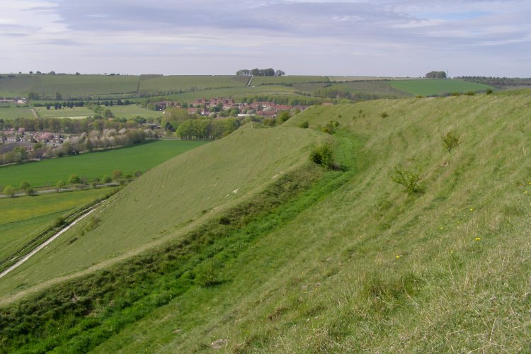
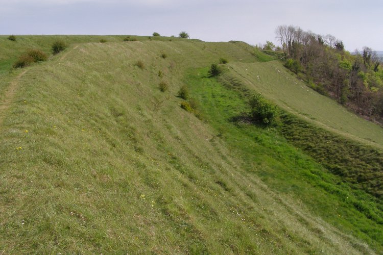
Battlesbury Camp submitted by JimChampion : Southwest flank of Battlesbury Hill, showing the ramparts of Battlesbury Camp. The buildings beyond are part of the army's Warminster Training Area. This side of the hill overlooks the Wylye valley. (Vote or comment on this photo)

Battlesbury Camp
Battlesbury Camp submitted by JimChampion : Battlesbury Camp is defended by a double row of earthen banks - this view is looking southeast along the soutwestern flank of the hill. The trees on the right are part of Battlesbury Wood on the southern slopes of the hill. (Vote or comment on this photo)

Battlesbury Camp
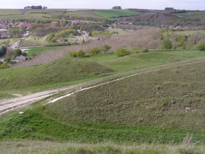
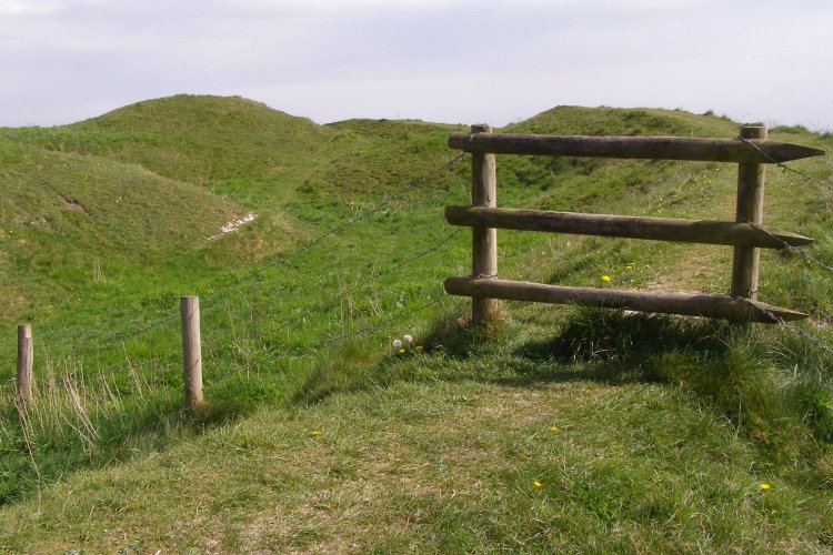
Battlesbury Camp submitted by JimChampion : On the southern edge of Battlesbury Camp. The inner rampart is in the foreground and to the right. To the left is the area within the camp from which material was quarried to build up the rampart. There are also two bowl barrows in this region. One is large and obvious, seen here towards the left (at grid reference ST89804545). The other is smaller, with its right hand side overlain by the hillfor... (Vote or comment on this photo)

Battlesbury Camp
Battlesbury Camp submitted by JimChampion : A view of the area just to the north of the northwest entrace to Battlesbury Camp. The outer rampart crosses the foreground. Beyond that are some other earthworks, the one on the right could be a dewpond? The English Heritage scheduling document says that there is an Iron Age inhumation cemetery here outside the north-west entrance, where several human skeletons, skulls and part of a horse skeleto... (Vote or comment on this photo)

Battlesbury Camp
Battlesbury Camp submitted by JimChampion : Rampart at the eastern (possibly original) entrance to Battlesbury Camp. The star-headed post on top of the rampart is a marker for the military, I think it indicates that no one should dig here. The hillfort is on the western boundary of the MoD Salisbury Plain training area.

Battlesbury Camp
Battlesbury Camp submitted by JimChampion : Battlesbury Hill from the Imber Range footpath to the east. The earthworks on the top of the hill are the Iron Age ramparts of Battlesbury Camp, those lower down are medieval strip-lynchets. This site is on the edge of the MoD's Salisbury Plain training area and is very well preserved. The trees on the left hand side of the hill (the southwest facing slope) are part of Battlesbury Wood.

Battlesbury Camp
Battlesbury Camp submitted by JimChampion : Two-photo composite image of the northwest entrance to Battlesbury hillfort, grid reference ST896458. An Iron Age cemetery was found outside this entrance (to the right). The strong colours are a result of shooting towards the sun. (2 comments)

Do not use the above information on other web sites or publications without permission of the contributor.
Click here to see more info for this site

Nearby sites

Click here to view sites on an interactive OS map

Key: Red: member's photo, Blue: 3rd party photo, Yellow: other image, Green: no photo - please go there and take one, Grey: site destroyed

Download sites to:
KML (Google Earth)
GPX (GPS waypoints)
CSV (Garmin/Navman)
CSV (Excel)

To unlock full downloads you need to sign up as a Contributory Member. Otherwise downloads are limited to 50 sites.


Turn off the page maps and other distractions

Nearby sites listing. In the following links * = Image available
 150m S 180° Battlesbury Bowl Barrow 1 Round Barrow(s) (ST89804545)
 163m S 190° Battlesbury Bowl barrow 2 Round Barrow(s) (ST89774544)
 200m S 180° Battlesbury hillfort Barrows Round Barrow(s) (ST898454)
 200m S 180° Battlesbury bowl barrow 3 Round Barrow(s) (ST898454)
 1.1km S 182° King Barrow (Warminster) Long Barrow (ST8975044477)
 1.2km SE 125° Middle Hill* Round Barrow(s) (ST908449)
 1.5km NNW 348° Mancombe Down Enclosure Ancient Village or Settlement (ST89494710)
 1.6km NNE 16° Warminster Long Barrow Long Barrow (ST90244717)
 1.7km SSW 198° Boreham Mill Barrows Round Barrow(s) (ST89274400)
 1.8km W 269° Cop Heap Round Barrow(s) (ST87984558)
 1.9km NNE 18° Oxendean Down barrow Round Barrow(s) (ST904474)
 1.9km SE 137° Scratchbury Camp* Hillfort (ST911442)
 2.0km NNE 18° Oxendean Down Barrow Round Barrow(s) (ST90404746)
 2.0km NNE 17° Warminster Bowl Barrow Round Barrow(s) (ST90384747)
 2.1km E 80° Norton Bavant 14 Long Barrow (ST91854596)
 2.3km WNW 292° Warminster Round Barrow(s) (ST87674647)
 2.3km NNE 12° Oxendean Bottom Barrow Round Barrow(s) (ST90314788)
 2.4km WNW 285° Arn Hill Barrow Round Barrow(s) (ST87444623)
 2.5km WNW 284° Arn Hill barrow Round Barrow(s) (ST874462)
 2.7km WNW 300° Colloway Clump Barrow Round Barrow(s) (ST87464695)
 2.8km E 83° Norton Bavant 13 Long Barrow (ST92594595)
 2.8km WNW 302° Arn Hill Long Barrow Long Barrow (ST874471)
 2.9km N 10° Warminster Down Tumulus Round Barrow(s) (ST90294841)
 3.0km ESE 120° West Hill long barrow Long Barrow (ST924441)
 3.4km N 11° Bratton Round Barrow(s) (ST90434892)
View more nearby sites and additional images

<< Tafi del Valle

Millstone Burn 1b >>

Please add your thoughts on this site

Stonehenge Complete

Stonehenge Complete

Sponsors

Auto-Translation (Google)

Translate from English into:

"Battlesbury Camp" | Login/Create an Account | 6 News and Comments
  
Go back to top of page    Comments are owned by the poster. We aren't responsible for their content.
Concern due to illegal metal detecting at an unidentified site in the Warminster area by Andy B on Wednesday, 30 January 2013
(User Info | Send a Message)
English Heritage and Wiltshire Police are concerned about a spate of illegal metal detecting at a nationally important archaeological site in the Warminster area. The archaeology of the Warminster and Westbury area is exceptional and includes many important sites such as Battlesbury Hill, Cley Hill, Bratton Camp and Scratchbury Hill, all Iron Age hillforts over 2000 years old.

English Heritage staff recently visited one of these Scheduled Monuments and have seen evidence of ground disturbance characteristic of the type made by metal detectorists. They believe this heritage crime is not an isolated incident, with further holes likely to have been dug over the Christmas period.

Illicit metal detecting, also known as ‘nighthawking’is a form of theft, and those involved must not be confused with responsible metal detectorists who follow good practice guidelines, record and report their finds, and are valued contributors to the understanding of our shared heritage.

Inspector Lindsey Winter - Area Inspector for Warminster, Westbury, Tisbury and Mere said, "Many protected archaeological sites in Wiltshire are very popular places, but to hear that people are visiting these sites with the intention of stealing from the land is extremely disappointing. The general public need to understand that illegal metal detecting is an offence, and that those people visiting sites for this purpose are not welcome. Wiltshire Police are working with English Heritage in relation to such matters and we will be dealing robustly with anyone we find committing offences."

National Trust archaeologist Martin Papworth said: "This recent activity is of great concern. We have no idea what has been taken and the archaeological understanding and context of each item has now been lost."

Mark Harrison, Policing and Crime Advisor for English Heritage said: "The practice of illegal metal detecting and stealing artefacts from the ground is an issue that English Heritage takes very seriously. These are not people enjoying a hobby, nor professionals carrying out a careful study. Any objects removed belong to the landowner, and the history that is being stolen belongs to all of us. The theft of ancient artefacts robs us of important information about our heritage, and the artefacts themselves are lost to the public. English Heritage will continue to work closely with our partners in preventing heritage crime and ensuring perpetrators are brought to justice.”

Anyone with any information should contact English Heritage Tel: 0117 975 0700.

Source: Wiltshire Police

Note that there seems to a bit of 'hypeing' of this story going on. The release only says one of these sites was affected, they are not saying at which one this suspicious activity has occurred. The local paper seem to have interpreted it as all of "Battlesbury Hill, Cley Hill, Bratton Camp and Scratchbury Hill" but this is not my reading of it.

http://www.thisissomerset.co.uk/Treasure-hunters-warned-important-ancient-sites/story-17994349-detail/story.html

There's also a video from the BBC local news here. The BBC only refer to one site and said it was 'at a site they can't identify'.
http://www.bbc.co.uk/news/uk-england-wiltshire-21252389

No doubt people are on the alert in the area so if you do see anything suspicious please report it.
[ Reply to This ]

eBook: An Iron Age Settlement outside Battlesbury Hillfort, Warminster and more by Andy B on Sunday, 15 August 2010
(User Info | Send a Message)
by Chris Ellis and Andrew B. Powell
ISBN: 978-1-874350-47-7
Download a PDF of the full text of this book:
http://www.wessexarch.co.uk/files/An-Iron-Age-Settlement-outside-Battlesbury-Hillfort-and-Sites-along-the-Southern-Range-Road.pdf

Construction of a tank road through part of Salisbury Plain, from Warminster to Tilshead, has revealed archaeological remains dating from the Neolithic up to modern use of the Plain for military training. Excavation adjacent to Battlesbury Camp hillfort has uncovered Late Bronze Age to Middle Iron Age settlement activity including ditches, roundhouses, four-post structures and numerous pits. Some of the pits contained human burials, and other deposits of artefacts and animal bones appear to have been formally placed.

Detailed environmental investigation has provided information about both the nature of the on-site activities and the character of the surrounding landscape.

Other sites investigated along the tank road included a round barrow and a multiple inhumation and cremation burial of Early Bronze Age date, a Middle Bronze Age enclosure, Late Bronze Age settlement sites, the ‘Old Ditch' Wessex Linear earthwork and evidence for Romano-British settlement and landuse.
[ Reply to This ]

Re: Battlesbury Camp by coldrum on Sunday, 28 March 2010
(User Info | Send a Message)
Street View


View Larger Map
[ Reply to This ]

Re: Battlesbury Camp by coldrum on Friday, 07 August 2009
(User Info | Send a Message)
https://www.pastscape.org.uk/hob.aspx?hob_id=207489
[ Reply to This ]

Re: Battlesbury Camp by coldrum on Friday, 07 August 2009
(User Info | Send a Message)
Pastscape:

https://www.pastscape.org.uk/hob.aspx?hob_id=207399

https://www.pastscape.org.uk/hob.aspx?hob_id=863911
[ Reply to This ]

Re: Battlesbury Camp by JimChampion on Friday, 11 May 2007
(User Info | Send a Message)
From The Ancient History of Wiltshire by Sir Richard Colt Hoare (published 1812) Chapter No. 4 - Station 2: Warminster.
The next hill has its summit crowned by the bold and extensive fortress of BATTLESBURY, and is the most conspicuous feature in the whole vale. This camp occupies the summit of an irregular point of down, and is by nature almost inaccessible on the west and north-east sides. The area of it within the intrenchments contains twenty-three acres and a quarter; the circuit of the outer vallum is seven furlongs and sixty-six yards, and the greatest height of the ramparts is sixty feet. You will observe by the annexed plan, on the north and south sides, where the ground is the most accessible, additional ramparts have been raised: and that the entrances to the east and west are guarded with outworks. The south-west angle of this camp is a point deserving particular attention. There the whole space of the inner ditch is occupied by a large circular barrow, which Mr. Cunnington opened, but found no interment. A few feet further to the west are two other barrows, over which the great inner rampart passes; these on opening, proved to be sepulchral: in the largest was found a cist containing burned human bones at the depth of two feet; and in the smallest, two skeletons lying from south to north, the head of the smallest reclining on the breast of the other. On the breast of the largest skeleton there was a small ring or bead of stone, which was probably worn as an amulet.

These circumstances tend to throw some light upon the aera of this camp, and evidently prove to us that the tumuli existed previous to the construction of that part of it where they are situated; for we still see them untouched and repsected, and that ground taken from excavations near the large barrow, to raise the rampart, rather than disturb these ancient memorials of the dead. I doubt if the barbarous Saxons would have paid such a tribute of respect to their British predecessors.
Towards the north-west end of this camp are some small stone quarries, amongst which several human skeletons have at different times been found. Mr. Cunnington, observing some black earth amongst these excavations, dug there and found at the depth of two feet, a human skeleton with its head to the north, and near it the greater part of the skeleton of a horse. The whole area of this camp has been in tillage for many years, and several Roman coins have been found; amongst them a large one in brass of Trajan, which is in the possession of Mr. Cunnington.

Those who are fond of elevated and commanding points of view, will be highly gratified in visiting our ancient camps; and few of them will be found more interesting than Battlesbury, whether we consider it in a military light, and admire the boldness of its situation and the strength of its ramparts, or whether in tracing its circumference, our attention is more particularly directed to the rich and extensive scenery that surrounds it. On the north side of the camp, where the hill is most precipitate, the lynchets* have a very singular appearance, like a continued line of broken ramparts.

* This word lynchet, is a corruption from land-sheare, a shred or strip of land; they are frequent at the declivities of our chalk hills, and are produced by the natural effect of the plough on sloping ground.

Engraving of the camp's plan on Wiltshire County Council's website.
[ Reply to This ]

Your Name: Anonymous [ Register Now ]
Subject:


Add your comment or contribution to this page. Spam or offensive posts are deleted immediately, don't even bother

<<< What is five plus one as a number? (Please type the answer to this question in the little box on the left)
You can also embed videos and other things. For Youtube please copy and paste the 'embed code'.
For Google Street View please include Street View in the text.
Create a web link like this: <a href="https://www.megalithic.co.uk">This is a link</a>  

Allowed HTML is:
<p> <b> <i> <a> <img> <em> <br> <strong> <blockquote> <tt> <li> <ol> <ul> <object> <param> <embed> <iframe>

We would like to know more about this location. Please feel free to add a brief description and any relevant information in your own language.
Wir möchten mehr über diese Stätte erfahren. Bitte zögern Sie nicht, eine kurze Beschreibung und relevante Informationen in Deutsch hinzuzufügen.
Nous aimerions en savoir encore un peu sur les lieux. S'il vous plaît n'hesitez pas à ajouter une courte description et tous les renseignements pertinents dans votre propre langue.
Quisieramos informarnos un poco más de las lugares. No dude en añadir una breve descripción y otros datos relevantes en su propio idioma.