


<< Our Photo Pages >> Dunsdale (College Valley) - Ancient Village or Settlement in England in Northumberland
Submitted by Anne T on Thursday, 14 September 2017 Page Views: 1437
Multi-periodSite Name: Dunsdale (College Valley)Country: England
NOTE: This site is 2.867 km away from the location you searched for.
County: Northumberland Type: Ancient Village or Settlement
Nearest Town: Wooler Nearest Village: Hethpool
Map Ref: NT9005823240
Latitude: 55.502835N Longitude: 2.158946W
Condition:
| 5 | Perfect |
| 4 | Almost Perfect |
| 3 | Reasonable but with some damage |
| 2 | Ruined but still recognisable as an ancient site |
| 1 | Pretty much destroyed, possibly visible as crop marks |
| 0 | No data. |
| -1 | Completely destroyed |
| 5 | Superb |
| 4 | Good |
| 3 | Ordinary |
| 2 | Not Good |
| 1 | Awful |
| 0 | No data. |
| 5 | Can be driven to, probably with disabled access |
| 4 | Short walk on a footpath |
| 3 | Requiring a bit more of a walk |
| 2 | A long walk |
| 1 | In the middle of nowhere, a nightmare to find |
| 0 | No data. |
| 5 | co-ordinates taken by GPS or official recorded co-ordinates |
| 4 | co-ordinates scaled from a detailed map |
| 3 | co-ordinates scaled from a bad map |
| 2 | co-ordinates of the nearest village |
| 1 | co-ordinates of the nearest town |
| 0 | no data |
Internal Links:
External Links:
I have visited· I would like to visit
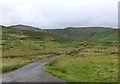
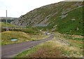
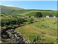
Anne T visited on 12th Sep 2017 - their rating: Cond: 1 Amb: 4 Access: 5 Dunsdale Settlement, College Valley: Wow. The screen slopes to the north of this path are daunting and impressive at the same time. If there was a landslip here, you might be cut off for some time.
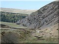
The settlement here was difficult to make out because of the very tall grass and heather, but we could feel stone foundations under our feet and depressions in the ground.
It is a very beautiful spot, with the scree slopes of Dunsdale Crag to the north and Bizzle Burn running to the west of this site.
Would really like to come back here in winter to see more of the site structure.
 (PID:170625)")
This Roman British Enclosed Settlement, cut by a later medieval shieling, is recorded as Pastscape Monument No. 3552 and Historic England List ID 1014680.
Whilst the deep grass and bracken hid most of the outline and internal structures of the settlement, we could feel stone foundations underneath our feet, and make out depressions in the ground between them.
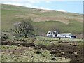
The enclosure lies in an impressive location, sitting between Bizzle Burn and Lambden Burn, north east of Dunsdale Farmhouse. An extract from the Historic England listing reads: "The monument consists of three conjoined enclosures of earth and stone banks, the interiors of the enclosures are slightly scooped into the ground surface. The circular stone foundations of several prehistoric buildings lie within and adjacent to the enclosures. The stone foundation of a rectangular building of medieval date, interpreted as a shieling, lies to the east of the enclosures and is included within the monument. The site is situated on a small area of level ground on the very edge of the steep east bank of the Bizzle Burn, the ground also falls away sharply to the north where the Bizzle Burn joins the main valley of the Lambden Burn. The settlement is overlooked to north and south by the steep slopes of The Cheviot and Coldburn Hill."
You may be viewing yesterday's version of this page. To see the most up to date information please register for a free account.
 (PID:170623)")
 (PID:170626)")
Do not use the above information on other web sites or publications without permission of the contributor.
Nearby Images from Geograph Britain and Ireland:
©2022(licence)
©2013(licence)
©2022(licence)
©2013(licence)
©2014(licence)
The above images may not be of the site on this page, they are loaded from Geograph.
Please Submit an Image of this site or go out and take one for us!
Click here to see more info for this site
Nearby sites
Key: Red: member's photo, Blue: 3rd party photo, Yellow: other image, Green: no photo - please go there and take one, Grey: site destroyed
Download sites to:
KML (Google Earth)
GPX (GPS waypoints)
CSV (Garmin/Navman)
CSV (Excel)
To unlock full downloads you need to sign up as a Contributory Member. Otherwise downloads are limited to 50 sites.
Turn off the page maps and other distractions
Nearby sites listing. In the following links * = Image available
1.3km NW 320° Coldburn (College Valley)* Ancient Village or Settlement (NT8924924207)
2.1km NW 315° Southernknowe Farmstead (College Valley)* Ancient Village or Settlement (NT8854124761)
2.2km WSW 248° Mounthooly (College Valley)* Ancient Village or Settlement (NT8803022426)
2.3km NNW 328° Southernknowe (College Valley)* Ancient Village or Settlement (NT88842520)
4.1km NNE 25° Yeavering Bell Stone Circle Stone Circle (NT918270)
4.4km NNW 348° Hethpool Cairn* Cairn (NT8913027519)
4.4km NNW 339° Great Hetha Camp* Hillfort (NT885274)
4.6km N 350° Hethpool Stone Circles* Stone Circle (NT89252778)
5.1km NNW 343° Little Hetha Hillfort (NT886281)
5.7km SW 226° Bonnielaws Hillfort* Hillfort (NT8589319312)
5.8km E 101° Langleeford 1 Rock Art (NT9577522147)
5.8km E 100° Langleeford N01 Rock Art (NT9580222191)
5.9km NNW 348° Hethpool 1 & 2 (Ewe Hill) Rock Art (NT8887028990)
5.9km WSW 241° Fasset Hill (Sourhope)* Ancient Village or Settlement (NT8492520359)
6.1km NNE 11° Torlee House, Kirknewton Rock Art (NT9127029190)
6.1km N 11° West Hill, Kirknewton* Rock Art (NT9125329199)
6.2km NW 308° Stob Stones* Standing Stones (NT85142710)
6.2km NW 307° Stob Rig (Yetholm)* Misc. Earthwork (NT85092704)
6.3km NNE 31° Whitelaw (Kirknewton) Rock Art (NT9330028600)
6.3km WSW 237° Sourhope Hillfort* Hillfort (NT8475219825)
6.3km N 8° West Hill Camp* Hillfort (NT9096029518)
6.5km NW 319° Coldsmouth Hill Ring Cairns* Cist (NT858282)
6.6km NNW 343° Mid Hill Ancient Village or Settlement (NT881295)
6.6km NNW 329° Ring Chesters* Hillfort (NT8670528905)
6.7km NNE 24° Yeavering Bell* Hillfort (NT92802931)
View more nearby sites and additional images


 We would like to know more about this location. Please feel free to add a brief description and any relevant information in your own language.
 Wir möchten mehr über diese Stätte erfahren. Bitte zögern Sie nicht, eine kurze Beschreibung und relevante Informationen in Deutsch hinzuzufügen.
 Nous aimerions en savoir encore un peu sur les lieux. S'il vous plaît n'hesitez pas à ajouter une courte description et tous les renseignements pertinents dans votre propre langue.
 Quisieramos informarnos un poco más de las lugares. No dude en añadir una breve descripción y otros datos relevantes en su propio idioma.