

<< Our Photo Pages >> Matxitxane Trikuharria - Burial Chamber or Dolmen in Spain in Pais Vasco
Submitted by davidmorgan on Sunday, 07 July 2013 Page Views: 1187
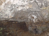
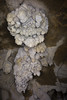
Neolithic and Bronze AgeSite Name: Matxitxane Trikuharria Alternative Name: IntsaustiCountry: Spain
NOTE: This site is 1.606 km away from the location you searched for.
Region: Pais Vasco Type: Burial Chamber or Dolmen
Nearest Town: Legazpi
Latitude: 42.989514N Longitude: 2.129682W
Condition:
| 5 | Perfect |
| 4 | Almost Perfect |
| 3 | Reasonable but with some damage |
| 2 | Ruined but still recognisable as an ancient site |
| 1 | Pretty much destroyed, possibly visible as crop marks |
| 0 | No data. |
| -1 | Completely destroyed |
| 5 | Superb |
| 4 | Good |
| 3 | Ordinary |
| 2 | Not Good |
| 1 | Awful |
| 0 | No data. |
| 5 | Can be driven to, probably with disabled access |
| 4 | Short walk on a footpath |
| 3 | Requiring a bit more of a walk |
| 2 | A long walk |
| 1 | In the middle of nowhere, a nightmare to find |
| 0 | No data. |
| 5 | co-ordinates taken by GPS or official recorded co-ordinates |
| 4 | co-ordinates scaled from a detailed map |
| 3 | co-ordinates scaled from a bad map |
| 2 | co-ordinates of the nearest village |
| 1 | co-ordinates of the nearest town |
| 0 | no data |
Be the first person to rate this site - see the 'Contribute!' box in the right hand menu.
Internal Links:
External Links:
")
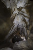
A dolmen in the Parque Natural de Aizkorri-Aratz.
You may be viewing yesterday's version of this page. To see the most up to date information please register for a free account.
")
")
")
")
Do not use the above information on other web sites or publications without permission of the contributor.
Nearby Images from Flickr
The above images may not be of the site on this page, but were taken nearby. They are loaded from Flickr so please click on them for image credits.
Click here to see more info for this site
Nearby sites
Click here to view sites on an interactive map of the areaKey: Red: member's photo, Blue: 3rd party photo, Yellow: other image, Green: no photo - please go there and take one, Grey: site destroyed
Download sites to:
KML (Google Earth)
GPX (GPS waypoints)
CSV (Garmin/Navman)
CSV (Excel)
To unlock full downloads you need to sign up as a Contributory Member. Otherwise downloads are limited to 50 sites.
Turn off the page maps and other distractions
Nearby sites listing. In the following links * = Image available
903m S 185° Erremedio Trikuharria Burial Chamber or Dolmen
1.1km S 182° Txotxeta Trikuharria Burial Chamber or Dolmen
1.2km ENE 65° Argarbi Trikuharria Burial Chamber or Dolmen
1.4km E 80° Ondarre 1 Harrespila* Stone Circle
1.4km E 80° Ondarre 2 Harrespila Stone Circle
1.4km ENE 72° Ondarre Zista* Cist
1.7km E 83° Jentillarri Zutarria* Standing Stone (Menhir)
1.7km ENE 75° Arraztarangaña Trikuharria* Burial Chamber or Dolmen
1.8km E 80° Jentillarri Trikuharria* Burial Chamber or Dolmen
1.9km NE 50° Aranzadi Trikuharria* Burial Chamber or Dolmen
2.1km SE 126° Labeo Trikuharria* Burial Chamber or Dolmen
2.2km E 90° Uidui 2 Trikuharria Burial Chamber or Dolmen
2.2km E 93° Supitaitz Zutarria* Standing Stone (Menhir)
2.3km E 94° Supitaitz 2 Tumulua Round Barrow(s)
2.3km ESE 118° Baiarrate Trikuharria Burial Chamber or Dolmen
2.3km E 90° Uidui 1 Ekialde Trikuharria Burial Chamber or Dolmen
2.6km NE 36° Atauru Gañe Zutarria Standing Stone (Menhir)
2.7km ENE 78° Pontoa 3+4 Etxola Hondoa Ancient Village or Settlement
2.8km NNE 15° Ausokoi 2 Trikuharria Burial Chamber or Dolmen
2.8km NE 34° Ausokoi Trikuharria* Burial Chamber or Dolmen
2.8km ENE 76° Pontoa 1+2 Etxola Hondoa Ancient Village or Settlement
2.9km E 82° Uelogoena 2 Ipar Trikuharria* Burial Chamber or Dolmen
2.9km E 83° Uelogoena 2 Hego Trikuharria* Burial Chamber or Dolmen
3.0km E 89° Zearragoena Trikuharria* Burial Chamber or Dolmen
3.1km NNE 33° Errekonta Trikuharria Burial Chamber or Dolmen
View more nearby sites and additional images


 We would like to know more about this location. Please feel free to add a brief description and any relevant information in your own language.
 Wir möchten mehr über diese Stätte erfahren. Bitte zögern Sie nicht, eine kurze Beschreibung und relevante Informationen in Deutsch hinzuzufügen.
 Nous aimerions en savoir encore un peu sur les lieux. S'il vous plaît n'hesitez pas à ajouter une courte description et tous les renseignements pertinents dans votre propre langue.
 Quisieramos informarnos un poco más de las lugares. No dude en añadir una breve descripción y otros datos relevantes en su propio idioma.