


<< Image Pages >> Blue Scar (Arncliffe) - Ancient Village or Settlement in England in Yorkshire (North)
Submitted by Anne T on Wednesday, 02 August 2017 Page Views: 3365
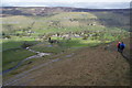
Multi-periodSite Name: Blue Scar (Arncliffe)Country: England County: Yorkshire (North) Type: Ancient Village or Settlement
Nearest Town: Grassington Nearest Village: Arncliffe
Map Ref: SD93237100
Latitude: 54.134799N Longitude: 2.105108W
Condition:
| 5 | Perfect |
| 4 | Almost Perfect |
| 3 | Reasonable but with some damage |
| 2 | Ruined but still recognisable as an ancient site |
| 1 | Pretty much destroyed, possibly visible as crop marks |
| 0 | No data. |
| -1 | Completely destroyed |
| 5 | Superb |
| 4 | Good |
| 3 | Ordinary |
| 2 | Not Good |
| 1 | Awful |
| 0 | No data. |
| 5 | Can be driven to, probably with disabled access |
| 4 | Short walk on a footpath |
| 3 | Requiring a bit more of a walk |
| 2 | A long walk |
| 1 | In the middle of nowhere, a nightmare to find |
| 0 | No data. |
| 5 | co-ordinates taken by GPS or official recorded co-ordinates |
| 4 | co-ordinates scaled from a detailed map |
| 3 | co-ordinates scaled from a bad map |
| 2 | co-ordinates of the nearest village |
| 1 | co-ordinates of the nearest town |
| 0 | no data |
Internal Links:
External Links:
")
The Northern Antiquarian (TNA) also features a page for this carving - see their entry for Arncliffe, Littondale, North Yorkshire, which includes a drawing of the carving, together with a description the carving and where it was found.
Historic England have a record for Blue Scar, Site ID 1004123 but this says that they only currently have paper records available for this scheduled site.
Source: Pastscape Monument No. 47163. This Pastscape record describes in detail this "complex of enclosures and hut circles and a field system, probably an Iron Age/Romano-British settlement. This site was probably partially reused for sheepfolds in the Medieval period with the addition of rectangular structures. Possible Prehistoric cairn. Scheduled."
The Northern Antiquarian (TNA) also have a page for the settlement - see their entry for Blue Scar Settlement, Arncliffe, North Yorkshire, where they have directions on how to find the site, a drawing of the main part of the settlement from 1929 (reproduced here with thanks), and a section on the archaeology and history of the settlement.
Note: The Arncliffe Carving
You may be viewing yesterday's version of this page. To see the most up to date information please register for a free account.
 (PID:168732)")
Do not use the above information on other web sites or publications without permission of the contributor.
Nearby Images from Geograph Britain and Ireland:
©2006(licence)
©2006(licence)
©2009(licence)
©2009(licence)
©2012(licence)
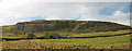
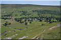
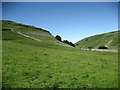
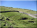
The above images may not be of the site on this page, they are loaded from Geograph.
Please Submit an Image of this site or go out and take one for us!
Click here to see more info for this site
Nearby sites
Key: Red: member's photo, Blue: 3rd party photo, Yellow: other image, Green: no photo - please go there and take one, Grey: site destroyed
Download sites to:
KML (Google Earth)
GPX (GPS waypoints)
CSV (Garmin/Navman)
CSV (Excel)
To unlock full downloads you need to sign up as a Contributory Member. Otherwise downloads are limited to 50 sites.
Turn off the page maps and other distractions
Nearby sites listing. In the following links * = Image available
2.5km SW 233° Dewbottoms (Arncliffe) Ancient Village or Settlement (SD912695)
2.8km SE 134° Douky Bottom Settlement (Arncliffe) Ancient Village or Settlement (SD9520369067)
2.8km SE 138° Douky Bottom Ring (Arncliffe) Ancient Village or Settlement (SD9512668887)
2.9km SE 137° Dowkerbottom Cave* Cave or Rock Shelter (SD95176889)
3.5km SSE 148° Kilnsey* Stone Circle (SD951680)
5.7km SSE 158° Lantern Holes (Bordley)* Ancient Village or Settlement (SD95336566)
6.0km SSE 163° Druid's Altar (Yorkshire)* Stone Circle (SD94946527)
6.1km SSE 162° Hammond Close Stone (Threshfield) Standing Stones (SD9516165209)
6.2km SSW 204° Seaty Hill (Malham Moor) Cairn (SD9069265390)
6.4km SSE 160° Hammond Close (Threshfield)* Ancient Village or Settlement (SD95386492)
6.6km NE 47° Tor Dike Ancient Village or Settlement (SD98137551)
6.7km SSW 211° Torlery Edge (Malham Moor) Ancient Village or Settlement (SD8978465292)
7.1km SE 143° Chapel House Wood* Ancient Village or Settlement (SD9750165316)
7.2km SSE 153° Heights Cave* Cave or Rock Shelter (SD96446460)
7.2km NE 49° Little Hunters Sleets Cairn Cairn (SD98647576)
7.3km SSW 212° Comb Scar* Ancient Village or Settlement (SD89366485)
7.5km SSW 211° Ing Scar* Ancient Village or Settlement (SD8931964626)
7.6km SE 142° Brazen Gate* Round Cairn (SD9785964995)
7.8km SE 127° Lea Green cairn Cairn (SD995663)
7.9km WNW 287° Giant's Graves (Halton Gill) Cairn (SD8564873346)
8.0km SSW 200° Malham settlements and field systems* Ancient Village or Settlement (SD905635)
8.1km SSW 213° Jorden Scar* Ancient Village or Settlement (SD88776419)
8.2km SW 217° Ewe Moor* Ring Cairn (SD88326445)
8.4km SE 143° Little Wood* Ancient Village or Settlement (SD98266429)
8.7km ESE 113° Green Hill Pasture Stone Circle* Stone Circle (SE013676)
View more nearby sites and additional images


 We would like to know more about this location. Please feel free to add a brief description and any relevant information in your own language.
 Wir möchten mehr über diese Stätte erfahren. Bitte zögern Sie nicht, eine kurze Beschreibung und relevante Informationen in Deutsch hinzuzufügen.
 Nous aimerions en savoir encore un peu sur les lieux. S'il vous plaît n'hesitez pas à ajouter une courte description et tous les renseignements pertinents dans votre propre langue.
 Quisieramos informarnos un poco más de las lugares. No dude en añadir una breve descripción y otros datos relevantes en su propio idioma.