


<< Text Pages >> Reys Cross (Stainmore) - Ancient Cross in England in County Durham
Submitted by Anne T on Sunday, 27 January 2019 Page Views: 1387
Early Medieval (Dark Age)Site Name: Reys Cross (Stainmore)Country: England
NOTE: This site is 2.622 km away from the location you searched for.
County: County Durham Type: Ancient Cross
Nearest Town: Barnard Castle Nearest Village: Bowes / Old Spital
Map Ref: NY9047012284
Latitude: 54.505779N Longitude: 2.148683W
Condition:
| 5 | Perfect |
| 4 | Almost Perfect |
| 3 | Reasonable but with some damage |
| 2 | Ruined but still recognisable as an ancient site |
| 1 | Pretty much destroyed, possibly visible as crop marks |
| 0 | No data. |
| -1 | Completely destroyed |
| 5 | Superb |
| 4 | Good |
| 3 | Ordinary |
| 2 | Not Good |
| 1 | Awful |
| 0 | No data. |
| 5 | Can be driven to, probably with disabled access |
| 4 | Short walk on a footpath |
| 3 | Requiring a bit more of a walk |
| 2 | A long walk |
| 1 | In the middle of nowhere, a nightmare to find |
| 0 | No data. |
| 5 | co-ordinates taken by GPS or official recorded co-ordinates |
| 4 | co-ordinates scaled from a detailed map |
| 3 | co-ordinates scaled from a bad map |
| 2 | co-ordinates of the nearest village |
| 1 | co-ordinates of the nearest town |
| 0 | no data |
Be the first person to rate this site - see the 'Contribute!' box in the right hand menu.
Internal Links:
External Links:
I have visited· I would like to visit
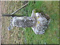
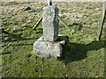
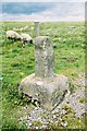
paulxtr visited on 27th Mar 2016 - their rating: Cond: 3 Amb: 3 Access: 5 This monument is more properly known as the 'Rey Cross' (or occasionally 'Rere Cross'). The cross was originally located approximately 500 metres due west of its current position at the summit of the road within the Roman Marching Camp. In August 1990 the cross was lifted from its original position and moved to the Bowes Museum to keep it safe while the A66 was dualled. It was placed in its current position in 1992.
Sited just to the east of Rey Cross Roman Temporary Camp and signal station and prehistoric stone circle (now bisected by the A66), this cross is scheduled as Historic England List ID 1016467 and recorded as Pastscape Monument No. 876746, where it is sited close to the ancient county boundary of (now) Cumbria and County Durham.
Historic England tells us the cross is located near the highest point of Stainmore and consists of a weathered sandstone cross shaft and base. "The rectangular cross base measures 0.6m by 0.7m and is 0.4m deep. The shaft stands 0.68m high and is 0.29m by 0.26m thick at its base. The top of the shaft has slightly rounded edges and the top of each face thickens slightly." The cross was moved to its current position in 1990, having originally been south of the A66, and the HE entry adds: "Documents also show that in 1258 the cross served as a boundary marker for the Diocese of Glasgow".
The Journal of Antiquities also features an entry for this cross as part of its page for Rey Cross Roman Camp, Stainmore, Cumbria; scroll down the page for background information, a photograph and sources of more information.
You may be viewing yesterday's version of this page. To see the most up to date information please register for a free account.
Do not use the above information on other web sites or publications without permission of the contributor.
Nearby Images from Geograph Britain and Ireland:
©2019(licence)
©2024(licence)
©2008(licence)
©2012(licence)
©2023(licence)
The above images may not be of the site on this page, they are loaded from Geograph.
Please Submit an Image of this site or go out and take one for us!
Click here to see more info for this site
Nearby sites
Key: Red: member's photo, Blue: 3rd party photo, Yellow: other image, Green: no photo - please go there and take one, Grey: site destroyed
Download sites to:
KML (Google Earth)
GPX (GPS waypoints)
CSV (Garmin/Navman)
CSV (Excel)
To unlock full downloads you need to sign up as a Contributory Member. Otherwise downloads are limited to 50 sites.
Turn off the page maps and other distractions
Nearby sites listing. In the following links * = Image available
6.6km SE 133° Mudbeck 2 (Arkengarthdale Moor) Rock Art (NY9527407728)
6.9km SE 132° Mudbeck Stone Circle (NY9562607618)
7.0km WNW 285° Dyke House Hillfort (NY837141)
7.4km NE 43° Goldsborough Rigg 10* Rock Art (NY9559417708)
7.5km NE 44° Goldsborough Rigg 5* Rock Art (NY9567817676)
7.5km NE 44° Goldsborough Rigg 11 Rock Art (NY9567517681)
7.5km NE 44° Goldsborough Rigg 9* Rock Art (NY9567617682)
7.5km NE 44° Goldsborough Rigg 3* Rock Art (NY9569517697)
7.5km NE 44° Goldsborough Rigg 12 Rock Art (NY9570417692)
7.5km NE 44° Goldsborough Rigg 13 Rock Art (NY9570717701)
7.5km NE 44° Goldsborough Rigg 1.* Rock Art (NY9571117705)
7.6km NE 45° Goldsborough Rigg 4 Rock Art (NY9580517666)
7.6km NE 44° Goldsborough Rigg 2* Rock Art (NY9578417719)
7.6km NE 35° Blackton Reservoir 1* Rock Art (NY9484518555)
7.6km NE 44° Goldsborough Rigg 14 Rock Art (NY9584017745)
7.7km NE 54° Kearton Rigg 1* Rock Art (NY9670916801)
7.7km NE 54° Kearton Rigg 2 Rock Art (NY9671816799)
7.8km NE 45° Goldsborough Rigg 7 Rock Art (NY9599617742)
7.8km NE 51° West Loups's 5* Rock Art (NY9655117135)
7.8km NE 48° How Beck Head 8* Rock Art (NY9630317467)
7.8km NE 51° West Loups's 4* Rock Art (NY9658717169)
7.9km NE 45° Goldsborough Rigg 6 Rock Art (NY9601717884)
7.9km NE 52° West Loups's 3* Rock Art (NY9670817181)
7.9km NE 44° Goldsborough Rigg 15 Rock Art (NY9602517948)
8.0km NE 51° West Loups's 2* Rock Art (NY9669617259)
View more nearby sites and additional images


 We would like to know more about this location. Please feel free to add a brief description and any relevant information in your own language.
 Wir möchten mehr über diese Stätte erfahren. Bitte zögern Sie nicht, eine kurze Beschreibung und relevante Informationen in Deutsch hinzuzufügen.
 Nous aimerions en savoir encore un peu sur les lieux. S'il vous plaît n'hesitez pas à ajouter une courte description et tous les renseignements pertinents dans votre propre langue.
 Quisieramos informarnos un poco más de las lugares. No dude en añadir una breve descripción y otros datos relevantes en su propio idioma.