


<< Our Photo Pages >> Chettle Long Barrow - Long Barrow in England in Dorset
Submitted by beaconhill on Wednesday, 20 April 2005 Page Views: 7798
Neolithic and Bronze AgeSite Name: Chettle Long Barrow Alternative Name: Chettle WoodCountry: England County: Dorset Type: Long Barrow
Nearest Town: Blandford Forum Nearest Village: Chettle
Map Ref: ST937135
Latitude: 50.920923N Longitude: 2.090999W
Condition:
| 5 | Perfect |
| 4 | Almost Perfect |
| 3 | Reasonable but with some damage |
| 2 | Ruined but still recognisable as an ancient site |
| 1 | Pretty much destroyed, possibly visible as crop marks |
| 0 | No data. |
| -1 | Completely destroyed |
| 5 | Superb |
| 4 | Good |
| 3 | Ordinary |
| 2 | Not Good |
| 1 | Awful |
| 0 | No data. |
| 5 | Can be driven to, probably with disabled access |
| 4 | Short walk on a footpath |
| 3 | Requiring a bit more of a walk |
| 2 | A long walk |
| 1 | In the middle of nowhere, a nightmare to find |
| 0 | No data. |
| 5 | co-ordinates taken by GPS or official recorded co-ordinates |
| 4 | co-ordinates scaled from a detailed map |
| 3 | co-ordinates scaled from a bad map |
| 2 | co-ordinates of the nearest village |
| 1 | co-ordinates of the nearest town |
| 0 | no data |
Internal Links:
External Links:
I have visited· I would like to visit
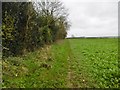
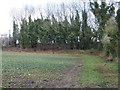
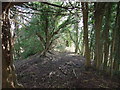
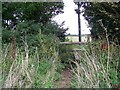
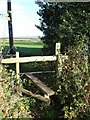
beaconhill visited on 1st Jun 2018 - their rating: Amb: 3 Access: 3 Very overgrown with weeds but clearly visible is this massive long barrow, tapering at one end. It's on an impressive site with views in all directions. A hedgerow with some quite big trees in it passes the barrow so you have to go through a hole in the hedge (on footpath) to look both ways. Nice.
")
Very overgrown with weeds but clearly visible is this massive long barrow, tapering at one end. It's on an impressive site with views in all directions. A hedgerow with some quite big trees in it passes the barrow so you have to go through a hole in the hedge (on footpath) to look both ways. Nice.
Page originally by Jim Champion
You may be viewing yesterday's version of this page. To see the most up to date information please register for a free account.
Do not use the above information on other web sites or publications without permission of the contributor.
Nearby Images from Geograph Britain and Ireland:
©2015(licence)
©2010(licence)
©2010(licence)
©2008(licence)
©2006(licence)
The above images may not be of the site on this page, they are loaded from Geograph.
Please Submit an Image of this site or go out and take one for us!
Click here to see more info for this site
Nearby sites
Key: Red: member's photo, Blue: 3rd party photo, Yellow: other image, Green: no photo - please go there and take one, Grey: site destroyed
Download sites to:
KML (Google Earth)
GPX (GPS waypoints)
CSV (Garmin/Navman)
CSV (Excel)
To unlock full downloads you need to sign up as a Contributory Member. Otherwise downloads are limited to 50 sites.
Turn off the page maps and other distractions
Nearby sites listing. In the following links * = Image available
1.5km ESE 117° Chettle House* Long Barrow (ST9506612803)
2.2km NNW 342° Caesar's Camp (Dorset)* Hillfort (ST930156)
2.7km E 98° Thickthorn Farm Long Barrow (ST964131)
3.4km ESE 109° Gussage St Michael Cursus Cursus (ST969124)
3.4km E 100° Ogden Down 3 Timber Circle (ST971129)
3.5km ESE 110° Thickthorn Down (North)* Long Barrow (ST970123)
3.6km SSW 214° Pimperne Long Barrow* Long Barrow (ST917105)
3.6km ESE 111° Thickthorn Round Barrows* Round Barrow(s) (ST971122)
3.6km ESE 111° Thickthorn Down (South)* Long Barrow (ST971122)
4.9km ESE 116° Parsonage Hill* Long Barrow (ST98131137)
5.3km E 85° Gussage Hill Ancient Village or Settlement (ST990140)
5.5km E 94° Gussage South-East Long Barrow (ST992131)
5.6km E 87° Gussage Down (North)* Long Barrow (ST993138)
5.6km NE 38° Scrubbity Barrows* Barrow Cemetery (ST97201789)
5.6km SSW 204° Blandford Race Down Round Barrow(s) (ST91360836)
5.7km E 89° Gussage Down (South)* Long Barrow (ST994136)
7.1km ENE 75° Wyke Down henge* Henge (SU006153)
7.1km NW 312° Fontmell Down* Misc. Earthwork (ST884183)
7.2km SSW 197° Tarrant Rawston Long Barrow* Long Barrow (ST91550667)
7.4km ENE 77° Wyke Down barrows* Round Barrow(s) (SU009152)
7.6km SW 216° Pimperne Maze Turf Maze (ST892074)
7.6km E 89° Monkton-up-Wimborne Late Neolithic pit circle/shaft complex* Misc. Earthwork (SU01311367)
7.7km SSW 193° Buzbury Rings* Ancient Village or Settlement (ST919060)
7.8km E 81° Drive Plantation* Long Barrow (SU014147)
8.1km ENE 75° Pentridge Cursus Cursus (SU015156)
View more nearby sites and additional images


 We would like to know more about this location. Please feel free to add a brief description and any relevant information in your own language.
 Wir möchten mehr über diese Stätte erfahren. Bitte zögern Sie nicht, eine kurze Beschreibung und relevante Informationen in Deutsch hinzuzufügen.
 Nous aimerions en savoir encore un peu sur les lieux. S'il vous plaît n'hesitez pas à ajouter une courte description et tous les renseignements pertinents dans votre propre langue.
 Quisieramos informarnos un poco más de las lugares. No dude en añadir una breve descripción y otros datos relevantes en su propio idioma.