


<< Our Photo Pages >> Cat Low - Round Barrow(s) in England in Staffordshire
Submitted by astronomer on Sunday, 02 December 2012 Page Views: 3787
Neolithic and Bronze AgeSite Name: Cat Low Alternative Name: Cal Low, Callow Hill BarrowCountry: England
NOTE: This site is 5.504 km away from the location you searched for.
County: Staffordshire Type: Round Barrow(s)
Nearest Town: Stoke on Trent Nearest Village: Dilhorne
Map Ref: SJ97344320
Latitude: 52.986131N Longitude: 2.041071W
Condition:
| 5 | Perfect |
| 4 | Almost Perfect |
| 3 | Reasonable but with some damage |
| 2 | Ruined but still recognisable as an ancient site |
| 1 | Pretty much destroyed, possibly visible as crop marks |
| 0 | No data. |
| -1 | Completely destroyed |
| 5 | Superb |
| 4 | Good |
| 3 | Ordinary |
| 2 | Not Good |
| 1 | Awful |
| 0 | No data. |
| 5 | Can be driven to, probably with disabled access |
| 4 | Short walk on a footpath |
| 3 | Requiring a bit more of a walk |
| 2 | A long walk |
| 1 | In the middle of nowhere, a nightmare to find |
| 0 | No data. |
| 5 | co-ordinates taken by GPS or official recorded co-ordinates |
| 4 | co-ordinates scaled from a detailed map |
| 3 | co-ordinates scaled from a bad map |
| 2 | co-ordinates of the nearest village |
| 1 | co-ordinates of the nearest town |
| 0 | no data |
Internal Links:
External Links:
I have visited· I would like to visit
elad13 would like to visit
")
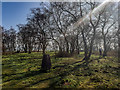
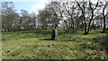
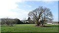
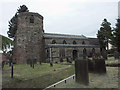
On false crest of Callow Hill approaching from W and overlooking the village of Dilhorne. Tumulus totally overgrown by brambles at the time of visit. Approached via the churchyard of All Saints, Dilhorne.
Church is Norman with unusual octagonal tower. Then follow track from the cemetery up the hill. Tumulus is passed as one approaches the trig point at 253 m set in small wood, St. Thomas's Trees.
Excavated by A.R.Mountford in 1955 when a rock cut grave discovered. Previously excavated in early 20thC. Last excavated in 1960s by Potteries Museum archaeological society. Tumulus about 35 feet in diameter with a height of about 2 feet. Shallow ditch on N side. Central depression probably due to excavations. Ref The Modern Antiquarian.
You may be viewing yesterday's version of this page. To see the most up to date information please register for a free account.
")
Do not use the above information on other web sites or publications without permission of the contributor.
Nearby Images from Geograph Britain and Ireland:
©2019(licence)
©2017(licence)
©2017(licence)
©2007(licence)
©2007(licence)
The above images may not be of the site on this page, they are loaded from Geograph.
Please Submit an Image of this site or go out and take one for us!
Click here to see more info for this site
Nearby sites
Key: Red: member's photo, Blue: 3rd party photo, Yellow: other image, Green: no photo - please go there and take one, Grey: site destroyed
Download sites to:
KML (Google Earth)
GPX (GPS waypoints)
CSV (Garmin/Navman)
CSV (Excel)
To unlock full downloads you need to sign up as a Contributory Member. Otherwise downloads are limited to 50 sites.
Turn off the page maps and other distractions
Nearby sites listing. In the following links * = Image available
7.2km WNW 289° Berryhill Fields* Modern Stone Circle etc (SJ905456)
7.6km SE 134° St Mary and All Saints (Checkley)* Ancient Cross (SK02783787)
8.3km NNE 32° Ipstones tympanum* Early Christian Sculptured Stone (SK01785022)
8.9km N 10° The Butter Cross (Cheddleton)* Ancient Cross (SJ989520)
9.1km NE 43° Hopestone ; Ipstones/Foxt ; Staffordshire Natural Stone / Erratic / Other Natural Feature (SK0361049834)
9.6km WNW 282° Stoke Minster* Ancient Cross (SJ8788745169)
9.8km E 90° Bunbury Hillfort (Alton Towers)* Hillfort (SK07164318)
9.9km ESE 122° Toot Hill Barrow (1) Round Barrow(s) (SK05773797)
10.0km WNW 294° Potteries Museum & Art Gallery* Museum (SJ8815147308)
10.1km WNW 298° Hanley Stone Circle* Modern Stone Circle etc (SJ884480)
10.2km NE 54° Windywaycross* Early Christian Sculptured Stone (SK056492)
10.5km SSW 202° Hollywood enclosure* Misc. Earthwork (SJ9338033501)
11.0km ENE 63° Hoften's Cross* Early Christian Sculptured Stone (SK072481)
11.0km WSW 258° St Mary and All Saints (Trentham)* Ancient Cross (SJ8654640940)
11.2km ENE 66° Cauldon Lowe Barrow Cemetery (SK076477)
11.3km NNE 16° Egg Well* Holy Well or Sacred Spring (SK00565403)
11.6km SW 231° Bury Bank (Staffordshire)* Hillfort (SJ883359)
11.8km WSW 236° Saxon's Lowe* Round Barrow(s) (SJ8750136662)
12.4km NE 38° The Morridge Stone Circle (SK0553)
12.8km WNW 283° Market Cross (Newcastle-under-Lyme) Ancient Cross (SJ8485745979)
12.8km N 6° Lady Well (Leek)* Holy Well or Sacred Spring (SJ9871455940)
13.2km ENE 77° Weaver Hills* Barrow Cemetery (SK102462)
13.2km N 2° Cock Low (Leek)* Round Barrow(s) (SJ9783656426)
13.2km ENE 56° Stonesteads* Round Barrow(s) (SK08405052)
13.4km N 5° Nicholson Museum and Art Gallery* Museum (SJ985566)
View more nearby sites and additional images


 We would like to know more about this location. Please feel free to add a brief description and any relevant information in your own language.
 Wir möchten mehr über diese Stätte erfahren. Bitte zögern Sie nicht, eine kurze Beschreibung und relevante Informationen in Deutsch hinzuzufügen.
 Nous aimerions en savoir encore un peu sur les lieux. S'il vous plaît n'hesitez pas à ajouter une courte description et tous les renseignements pertinents dans votre propre langue.
 Quisieramos informarnos un poco más de las lugares. No dude en añadir una breve descripción y otros datos relevantes en su propio idioma.