


<< Our Photo Pages >> Eastern Sanctuary Cross (Hexham) - Ancient Cross in England in Northumberland
Submitted by Anne T on Thursday, 05 September 2019 Page Views: 1537
Early Medieval (Dark Age)Site Name: Eastern Sanctuary Cross (Hexham) Alternative Name: Hexham Hospital Cross BaseCountry: England County: Northumberland Type: Ancient Cross
Nearest Town: Hexham
Map Ref: NY9411663937
Latitude: 54.970017N Longitude: 2.093443W
Condition:
| 5 | Perfect |
| 4 | Almost Perfect |
| 3 | Reasonable but with some damage |
| 2 | Ruined but still recognisable as an ancient site |
| 1 | Pretty much destroyed, possibly visible as crop marks |
| 0 | No data. |
| -1 | Completely destroyed |
| 5 | Superb |
| 4 | Good |
| 3 | Ordinary |
| 2 | Not Good |
| 1 | Awful |
| 0 | No data. |
| 5 | Can be driven to, probably with disabled access |
| 4 | Short walk on a footpath |
| 3 | Requiring a bit more of a walk |
| 2 | A long walk |
| 1 | In the middle of nowhere, a nightmare to find |
| 0 | No data. |
| 5 | co-ordinates taken by GPS or official recorded co-ordinates |
| 4 | co-ordinates scaled from a detailed map |
| 3 | co-ordinates scaled from a bad map |
| 2 | co-ordinates of the nearest village |
| 1 | co-ordinates of the nearest town |
| 0 | no data |
Internal Links:
External Links:
I have visited· I would like to visit
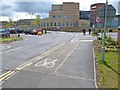
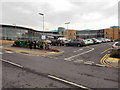
Anne T visited on 3rd Sep 2019 - their rating: Cond: 2 Amb: 2 Access: 5 Eastern Sanctuary Cross of Hexham Priory (or just the top of a gate post??): We stopped to photograph the scheduled Glover's Pant before making our way to the eastern side of Hexham. We were incredibly surprised to find this cross base, which we’ve looked for before, but at the old grid reference. On this visit, I spotted it straight away, and took its current grid location with our GPS. It is now sited at the eastern entrance to the car park. Andrew walked right past it, and I might have too, had I not remembered about the carved stone head being in the socket hole! I almost got myself run over trying to take photographs from various angles.
I also found Hodges’ 1897 paper listed in the Pastcape reference (copied in the text below). He reports that the locations of all four of Hexham Priory Sanctuary Crosses were now known. He reports the location of the northern one is at Cross Bank. I’m wondering if this is the one at Crag House, north of Acomb, although this is some 5km from the location of this cross base.
 (PID:202121)")
We'd long known there were Pastscape records for some of the Sanctuary Crosses for Hexham Priory, but never been able to find them before. This cross base is recorded as Pastscape Monument No. 18630, which placed it originally at NY 9418 6401, where, in 1897 it had "long been preserved at the Union Workhouse". The original location of the cross was just north of the hospital, in Path Head, and to preserve it, it was moved to the Workhouse, which at that time, was just to the west, in Dean Street, Hexham.
By 1956, it had been moved to the grounds of Hexham Hospital, just south of Dene Avenue, at NY 94146394, but by 1960 had been moved slightly to NY 9417 6394. Hexham Hospital was refurbished and extended in around 2006 (if memory serves me correctly) and so the cross base appears to have moved again.
In 1956, a field investigator commented: "This cross base stands in the grounds of HEXHAM HOSPITAL. It is 0.6m square and is 0.4 m. high. A carved stone head has been cemented into the socket hole. There is no ornament or inscription. Its unusual shape and absence of weathering make this stone of doubtful authenticity. It resembles the coping stone of a gate pillar."
C.C. Hodges, writing in 1897, reported that the western sanctuary cross had recently been discovered in a garden at Maiden Cross. He included a drawing of the base in his report to the Society of Antiquaries of Newcastle upon Tyne (Series 8, page 107) and added that the location of all four sanctuary crosses were now known. Hodges also mentions that the northern stone "still stood at Cross Bank"; presumably this is the Acomb Sanctuary Cross, which used to stand at Old Bridge End at NY 9292 6530 on the north side of the River Tyne [although this is over 4km away from this location (see nearby sites below), although I will try and verify this from other sources].
On a mission to try and find this cross base, together with some wells and holy wells in the area, finding this cross base was much easier than anticipated, although it is by far one of the strangest we've seen. Today the cross base sits at the entrance to the eastern car park of the hospital, and looks like one of the garden features/boulders the landscapers have recently installed. The only reason I recognised it was by the description in Pastscape of its pyramidal shape and the carved head cemented into its top.
The bottom of this cross base appears to resemble quite closely the base of Hodges' western cross base, although the top appears to have been chopped off and the carved head cemented into the socket hole.
If anyone has any more information about this curious monument, I'd love to hear!
You may be viewing yesterday's version of this page. To see the most up to date information please register for a free account.
 (PID:202123)")
 (PID:202122)")
 (PID:202120)")
Do not use the above information on other web sites or publications without permission of the contributor.
Nearby Images from Geograph Britain and Ireland:

©2016(licence)
©2012(licence)
©2013(licence)
©2006(licence)
©2017(licence)
The above images may not be of the site on this page, they are loaded from Geograph.
Please Submit an Image of this site or go out and take one for us!
Click here to see more info for this site
Nearby sites
Key: Red: member's photo, Blue: 3rd party photo, Yellow: other image, Green: no photo - please go there and take one, Grey: site destroyed
Download sites to:
KML (Google Earth)
GPX (GPS waypoints)
CSV (Garmin/Navman)
CSV (Excel)
To unlock full downloads you need to sign up as a Contributory Member. Otherwise downloads are limited to 50 sites.
Turn off the page maps and other distractions
Nearby sites listing. In the following links * = Image available
607m SSE 152° Shield Croft Farm, Hexham a, b & c Rock Art (NY9440063400)
623m WNW 284° Hexham Abbey* Ancient Cross (NY93516409)
915m WNW 287° Seal Well (Hexham)* Holy Well or Sacred Spring (NY93246421)
2.0km NNW 335° St John Lee Church (Oakwood Stone)* Rock Art (NY9329865718)
2.2km E 91° Dilston cists* Cist (NY963639)
3.6km NNW 330° Acomb Sanctuary Cross* Ancient Cross (NY9232067077)
3.8km NW 313° St Michael's Church (Warden)* Ancient Cross (NY9136166492)
4.2km ENE 77° Hadrian's Wall (Coria)* Stone Fort or Dun (NY9818064904)
4.2km ENE 78° Corbridge Rock Art Panel* Rock Art (NY9826764830)
4.7km E 84° St Andrew's Church (Corbridge)* Ancient Cross (NY98836443)
4.7km E 80° Old Prior Manor House Well (Corbridge)* Holy Well or Sacred Spring (NY9879164783)
4.7km E 84° Corbridge Crosses* Ancient Cross (NY9885564411)
5.1km E 84° Old Viney Museum (Corbridge)* Sculptured Stone (NY99226445)
5.1km N 351° Crag House Cross Base* Ancient Cross (NY9333869021)
5.3km NW 326° Homers Lane (Warden)* Rock Art (NY9112368334)
5.4km NW 317° Warden Hill Hillfort* Hillfort (NY9042367863)
5.5km NNW 337° Wall Crags Settlement* Ancient Village or Settlement (NY920690)
5.6km NW 326° Homers Lane Cross (Warden)* Ancient Cross (NY9097868555)
5.6km N 356° St Oswald in Lee (Heavenfield)* Ancient Cross (NY9369669560)
6.2km NNW 341° Hadrian's Wall (Brunton Turret)* Misc. Earthwork (NY9213469846)
6.3km NW 310° Fairy Stone (Fourstones) Natural Stone / Erratic / Other Natural Feature (NY893680)
6.4km WSW 250° The Hanging Stone (Haydon)* Standing Stone (Menhir) (NY8810161779)
6.4km SW 230° Jingling Gate* Ancient Village or Settlement (NY89145984)
6.7km NNW 336° Hadrian's Wall (Chesters Bridge Abutment)* Misc. Earthwork (NY9141970072)
6.7km NNW 336° Chesters Roman Site b* Rock Art (NY9142070076)
View more nearby sites and additional images


 We would like to know more about this location. Please feel free to add a brief description and any relevant information in your own language.
 Wir möchten mehr über diese Stätte erfahren. Bitte zögern Sie nicht, eine kurze Beschreibung und relevante Informationen in Deutsch hinzuzufügen.
 Nous aimerions en savoir encore un peu sur les lieux. S'il vous plaît n'hesitez pas à ajouter une courte description et tous les renseignements pertinents dans votre propre langue.
 Quisieramos informarnos un poco más de las lugares. No dude en añadir una breve descripción y otros datos relevantes en su propio idioma.