


<< Our Photo Pages >> The Wish Stone - Marker Stone in England in Gloucestershire
Submitted by mattchapman on Monday, 30 June 2014 Page Views: 5303
Multi-periodSite Name: The Wish Stone Alternative Name: The Tingle StoneCountry: England County: Gloucestershire Type: Marker Stone
Nearest Town: Cheltenham
Map Ref: SO950231
Latitude: 51.906414N Longitude: 2.074086W
Condition:
| 5 | Perfect |
| 4 | Almost Perfect |
| 3 | Reasonable but with some damage |
| 2 | Ruined but still recognisable as an ancient site |
| 1 | Pretty much destroyed, possibly visible as crop marks |
| 0 | No data. |
| -1 | Completely destroyed |
| 5 | Superb |
| 4 | Good |
| 3 | Ordinary |
| 2 | Not Good |
| 1 | Awful |
| 0 | No data. |
| 5 | Can be driven to, probably with disabled access |
| 4 | Short walk on a footpath |
| 3 | Requiring a bit more of a walk |
| 2 | A long walk |
| 1 | In the middle of nowhere, a nightmare to find |
| 0 | No data. |
| 5 | co-ordinates taken by GPS or official recorded co-ordinates |
| 4 | co-ordinates scaled from a detailed map |
| 3 | co-ordinates scaled from a bad map |
| 2 | co-ordinates of the nearest village |
| 1 | co-ordinates of the nearest town |
| 0 | no data |
Internal Links:
External Links:
I have visited· I would like to visit
SteveJJones has visited here
")
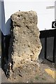
Small stone built into the corner of a house in Clarington Mews. It may have been used prevent damage to the wall but none of the other buildings have any such as this ? I was told that it was originally there and was just used. The reason for its name is that people would make a wish and place a stone on the rock as an offering. Many stone are still to found there showing its continued use.
You may be viewing yesterday's version of this page. To see the most up to date information please register for a free account.
")
")
")
Do not use the above information on other web sites or publications without permission of the contributor.
Nearby Images from Geograph Britain and Ireland:
©2012(licence)
![SO9523 : Cheltenham houses [120] by Michael Dibb](https://s2.geograph.org.uk/geophotos/06/91/72/6917226_6ea87609_120x120.jpg)
©2021(licence)
©2009(licence)
©2019(licence)
©2014(licence)
The above images may not be of the site on this page, they are loaded from Geograph.
Please Submit an Image of this site or go out and take one for us!
Click here to see more info for this site
Nearby sites
Key: Red: member's photo, Blue: 3rd party photo, Yellow: other image, Green: no photo - please go there and take one, Grey: site destroyed
Download sites to:
KML (Google Earth)
GPX (GPS waypoints)
CSV (Garmin/Navman)
CSV (Excel)
To unlock full downloads you need to sign up as a Contributory Member. Otherwise downloads are limited to 50 sites.
Turn off the page maps and other distractions
Nearby sites listing. In the following links * = Image available
530m SSW 193° Cheltenham Centre Stone* Marker Stone (SO9488422583)
670m SSW 206° Cheltenham Museum* Museum (SO947225)
3.4km E 87° Prestbury (Glos) Chambered Tomb (SO984233)
4.2km NE 56° Cleeve Hill (Gloucestershire)* Hillfort (SO98492546)
4.7km S 182° Leckhampton Hill* Hillfort (SO948184)
4.7km S 181° Leckhampton Hill Barrow* Round Barrow(s) (SO94911838)
4.7km NE 48° Cleeve Hill Cross Dyke* Misc. Earthwork (SO98562625)
4.9km NE 45° The Ring (Gloucestershire)* Ancient Village or Settlement (SO98472659)
5.9km SSW 195° Crippet's Barrow* Chambered Tomb (SO93421739)
6.0km NE 40° Cleeve Hill Barrows Round Barrow(s) (SO98872767)
6.2km SSW 194° Dry Heathfield Barrow Round Barrow(s) (SO93521711)
6.2km SE 137° Lineover* Chambered Tomb (SO99231856)
6.3km SE 130° North Dowdeswell* Hillfort (SO99851910)
6.3km NNE 33° Nottingham Hill* Hillfort (SO984284)
6.4km SSE 165° Seven Springs (Gloucestershire)* Holy Well or Sacred Spring (SO96631694)
6.4km NE 35° Nottingham Hill Carving (Gotherington)* Rock Art (SO98752835)
7.0km SE 130° South Dowdeswell Hillfort (SP0040018600)
7.1km NNE 28° Odo and Dodo* Standing Stones (SO98402935)
7.3km SSW 192° Emma's Grove Round Barrows Round Barrow(s) (SO93481594)
7.3km SSW 197° Crickley Hill* Hillfort (SO928161)
7.4km SSW 193° Barrow Wake Barrow Round Barrow(s) (SO93381585)
7.5km ENE 72° Belas Knap* Long Barrow (SP02092545)
7.5km SW 221° Badgeworth Round Barrow* Round Barrow(s) (SO90071750)
7.5km S 176° Coberley* Chambered Tomb (SO95521564)
8.1km WSW 239° Churchdown Hill Camp* Hillfort (SO881189)
View more nearby sites and additional images


 We would like to know more about this location. Please feel free to add a brief description and any relevant information in your own language.
 Wir möchten mehr über diese Stätte erfahren. Bitte zögern Sie nicht, eine kurze Beschreibung und relevante Informationen in Deutsch hinzuzufügen.
 Nous aimerions en savoir encore un peu sur les lieux. S'il vous plaît n'hesitez pas à ajouter une courte description et tous les renseignements pertinents dans votre propre langue.
 Quisieramos informarnos un poco más de las lugares. No dude en añadir una breve descripción y otros datos relevantes en su propio idioma.