


<< Our Photo Pages >> Sponds Hill N - Round Barrow(s) in England in Cheshire
Submitted by vicky on Tuesday, 20 August 2002 Page Views: 7390
Neolithic and Bronze AgeSite Name: Sponds Hill NCountry: England County: Cheshire Type: Round Barrow(s)
Nearest Town: Whaley Bridge Nearest Village: Kettleshulme
Map Ref: SJ970803 Landranger Map Number: 109
Latitude: 53.319618N Longitude: 2.046496W
Condition:
| 5 | Perfect |
| 4 | Almost Perfect |
| 3 | Reasonable but with some damage |
| 2 | Ruined but still recognisable as an ancient site |
| 1 | Pretty much destroyed, possibly visible as crop marks |
| 0 | No data. |
| -1 | Completely destroyed |
| 5 | Superb |
| 4 | Good |
| 3 | Ordinary |
| 2 | Not Good |
| 1 | Awful |
| 0 | No data. |
| 5 | Can be driven to, probably with disabled access |
| 4 | Short walk on a footpath |
| 3 | Requiring a bit more of a walk |
| 2 | A long walk |
| 1 | In the middle of nowhere, a nightmare to find |
| 0 | No data. |
| 5 | co-ordinates taken by GPS or official recorded co-ordinates |
| 4 | co-ordinates scaled from a detailed map |
| 3 | co-ordinates scaled from a bad map |
| 2 | co-ordinates of the nearest village |
| 1 | co-ordinates of the nearest town |
| 0 | no data |
Internal Links:
External Links:
I have visited· I would like to visit
BrownEdger would like to visit
")
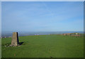
Sponds Hill lies on the border between Cheshire and Derbyshire within the estate of Lyme Hall and is reputedly one of the most notable objects to be seen from the Cheshire plain. The hill which runs north and south at 1348ft above sea level with fantastic views across to North Wales, Snowdon and the Great Orme, is home to three Bronze Age tumuli.
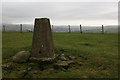
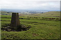
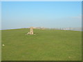
This barrow known as Sponds Hill Barrow North, stands on the summit of the hill capped by a trig point - the views from here are superb across the Chesire Plain, Manchester and the Pennines. A second barrow is located some 50 metres to the south. However, both are rather dilapidated examples and little is know of their history. The most notable lies on the spur of the hill on a natural mound, known as Reed Hill or Reed’s Piece, midway along the ridge.
Access
To visit this and Sponds Hill North, park at the Bowstones GR: SJ974813 and take the Gritstone Trail south for around a kilometre to the summit of the hill. References
D.M.Longley “Prehistory” in C.R.Elrington (ed) “The Victoria History of the County of Chester, volume 1, Oxford University Press (1987)
J. Barnatt & J. Collis “Barrows in the Peak District – Recent Research”, J.R.Collis Publications (1996)
You may be viewing yesterday's version of this page. To see the most up to date information please register for a free account.
Do not use the above information on other web sites or publications without permission of the contributor.
Nearby Images from Geograph Britain and Ireland:
©2006(licence)
©2012(licence)
©2012(licence)
©2012(licence)
©2020(licence)
The above images may not be of the site on this page, they are loaded from Geograph.
Please Submit an Image of this site or go out and take one for us!
Click here to see more info for this site
Nearby sites
Key: Red: member's photo, Blue: 3rd party photo, Yellow: other image, Green: no photo - please go there and take one, Grey: site destroyed
Download sites to:
KML (Google Earth)
GPX (GPS waypoints)
CSV (Garmin/Navman)
CSV (Excel)
To unlock full downloads you need to sign up as a Contributory Member. Otherwise downloads are limited to 50 sites.
Turn off the page maps and other distractions
Nearby sites listing. In the following links * = Image available
100m S 180° Sponds Hill S Round Barrow(s) (SJ970802)
892m ESE 117° Reed Hill* Round Barrow(s) (SJ978799)
1.1km NNE 21° Bowstones* Ancient Cross (SJ9739181309)
1.2km S 171° Further Harrop* Round Barrow(s) (SJ972791)
1.4km NNW 339° Knights Low W Round Barrow(s) (SJ965816)
1.4km NNW 335° Knights Low E* Round Barrow(s) (SJ964816)
1.5km SW 228° Andrew's Knob Round Barrow(s) (SJ959793)
1.5km NNW 340° Knightslow Wood W* Round Barrow(s) (SJ965817)
1.5km NNW 340° Knightslow Wood E Round Barrow(s) (SJ965817)
1.5km NNW 337° Knightslow Wood* Round Barrow(s) (SJ964817)
1.7km SSE 155° Charles Head* Round Barrow(s) (SJ977788)
1.7km ENE 62° Stone near Higher Cornfield Farm* Standing Stone (Menhir) (SJ985811)
1.7km NNW 332° Knights Low NW Round Barrow(s) (SJ962818)
2.1km NNW 345° Lyme Park* Ancient Cross (SJ96458235)
2.9km ENE 61° The Dipping Stone* Ancient Cross (SJ99558171)
3.0km SSW 212° Little Low Round Barrow(s) (SJ954777)
3.1km ENE 67° Hawkhurst Head* Standing Stone (Menhir) (SJ99838149)
3.2km SE 129° Windgather Rocks Cup-Mark Stone Rock Art (SJ995783)
3.3km WSW 249° Nab Wood Round Barrow(s) (SJ939791)
3.3km WSW 243° Nab Head (Cheshire)* Round Barrow(s) (SJ940788)
3.4km ENE 60° Ringstone (Whaley Bridge) Stone Circle (SK000820)
3.5km S 185° Highway Man Stone* Standing Stone (Menhir) (SJ9670476849)
3.5km SSW 201° Great Low Hillfort (SJ957770)
3.8km S 178° Blue Boar Farm* Round Barrow(s) (SJ971765)
3.9km SSW 199° Black Rock Farm* Round Barrow(s) (SJ957766)
View more nearby sites and additional images


 We would like to know more about this location. Please feel free to add a brief description and any relevant information in your own language.
 Wir möchten mehr über diese Stätte erfahren. Bitte zögern Sie nicht, eine kurze Beschreibung und relevante Informationen in Deutsch hinzuzufügen.
 Nous aimerions en savoir encore un peu sur les lieux. S'il vous plaît n'hesitez pas à ajouter une courte description et tous les renseignements pertinents dans votre propre langue.
 Quisieramos informarnos un poco más de las lugares. No dude en añadir una breve descripción y otros datos relevantes en su propio idioma.