


<< Our Photo Pages >> Pierre Pointue (Paimboeuf) - Standing Stone (Menhir) in France in Pays de la Loire:Loire-Atlantique
Submitted by thecaptain on Monday, 16 November 2009 Page Views: 3072
Neolithic and Bronze AgeSite Name: Pierre Pointue (Paimboeuf) Alternative Name: Menhir du Petit PaimboeufCountry: France
NOTE: This site is 0.594 km away from the location you searched for.
Département: Pays de la Loire:Loire-Atlantique Type: Standing Stone (Menhir)
Nearest Town: St Nazaire Nearest Village: Paimboeuf
Latitude: 47.283750N Longitude: 2.02354W
Condition:
| 5 | Perfect |
| 4 | Almost Perfect |
| 3 | Reasonable but with some damage |
| 2 | Ruined but still recognisable as an ancient site |
| 1 | Pretty much destroyed, possibly visible as crop marks |
| 0 | No data. |
| -1 | Completely destroyed |
| 5 | Superb |
| 4 | Good |
| 3 | Ordinary |
| 2 | Not Good |
| 1 | Awful |
| 0 | No data. |
| 5 | Can be driven to, probably with disabled access |
| 4 | Short walk on a footpath |
| 3 | Requiring a bit more of a walk |
| 2 | A long walk |
| 1 | In the middle of nowhere, a nightmare to find |
| 0 | No data. |
| 5 | co-ordinates taken by GPS or official recorded co-ordinates |
| 4 | co-ordinates scaled from a detailed map |
| 3 | co-ordinates scaled from a bad map |
| 2 | co-ordinates of the nearest village |
| 1 | co-ordinates of the nearest town |
| 0 | no data |
Internal Links:
External Links:
I have visited· I would like to visit
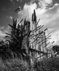
TheCaptain visited on 8th Jun 2005 - their rating: Cond: 2 Amb: 2 Access: 4 In the southeastern area of the town of Paimboeuf, amongst a housing estate, can be found a Rue de la menhir. Following this road from the main road, there is a right angled bend to the right, and a couple more older houses before you get to a building site for new houses. The menhir is somewhere down here, but well enough hidden that I couldnt find it. I asked an old gent who was out in his garden where the menhir was. He was delighted that I was there looking for it, and he showed me to a nearby house with a large wall around the garden, and pointed it out within the garden. He said he had complained to the Mairie several times about the new owner of the house building the wall, and hiding the menhir away from view, saying that as a historic monument it should be readily visible to all. It is about 1.6 metres tall, and can be seen over the top of the wall.
 (PID:52841)")
The menhir is somewhere down here, but well enough hidden that I couldnt find it. I asked an old gent who was out in his garden where the menhir was. He was delighted that I was there looking for it, and he showed me to a nearby house with a large wall around the garden, and pointed it out within the garden. He said he had complained to the Mairie several times about the new owner of the house building the wall, and hiding the menhir away from view, saying that as a historic monument it should be readily visible to all.
It is about 1.6 metres tall, and can be seen over the top of the wall.
You may be viewing yesterday's version of this page. To see the most up to date information please register for a free account.
 (PID:52840)")
 (PID:52786)")
Do not use the above information on other web sites or publications without permission of the contributor.
Nearby Images from Flickr
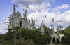
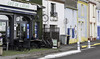
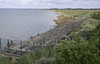
The above images may not be of the site on this page, but were taken nearby. They are loaded from Flickr so please click on them for image credits.
Click here to see more info for this site
Nearby sites
Click here to view sites on an interactive map of the areaKey: Red: member's photo, Blue: 3rd party photo, Yellow: other image, Green: no photo - please go there and take one, Grey: site destroyed
Download sites to:
KML (Google Earth)
GPX (GPS waypoints)
CSV (Garmin/Navman)
CSV (Excel)
To unlock full downloads you need to sign up as a Contributory Member. Otherwise downloads are limited to 50 sites.
Turn off the page maps and other distractions
Nearby sites listing. In the following links * = Image available
1.1km SSE 152° Menhir de la Tuterie* Standing Stone (Menhir)
3.9km SW 235° La Haute Gedeliere Dolmen* Passage Grave
4.0km NW 315° Menhir de la Vacherie (Donges)* Standing Stone (Menhir)
4.0km NW 315° Dolmen de la Vacherie (Donges)* Burial Chamber or Dolmen
4.2km SW 232° Menhir dit la Pierre Bonde* Standing Stone (Menhir)
4.2km WSW 247° Les Pierres Blanches (Corsept)* Standing Stones
5.2km NW 307° La Roche Dolmen (Donges) Burial Chamber or Dolmen
5.5km SW 219° La Gauterie Dolmen* Burial Chamber or Dolmen
5.8km SW 228° Megerie Menhir* Standing Stone (Menhir)
6.0km SSW 213° La Roche Govi Menhir* Standing Stone (Menhir)
6.2km SW 231° Cassis Menhir* Standing Stone (Menhir)
6.6km SW 220° Les Landes Menhir* Standing Stone (Menhir)
7.1km SW 219° La Bellevue Menhir* Standing Stone (Menhir)
8.2km NW 314° Menhir de Condé* Standing Stone (Menhir)
8.9km ENE 72° Pierre Des Huguenots* Standing Stone (Menhir)
8.9km ESE 120° Menhir des Pins* Standing Stone (Menhir)
9.9km WSW 244° Moulin Chevalier Dolmen* Passage Grave
10.1km S 174° Menhir de Biais Standing Stone (Menhir)
10.2km NNW 341° Trépied du Diable Standing Stones
10.3km SW 215° Le Riverais 2* Standing Stone (Menhir)
10.4km SW 216° Le Riverais 1* Standing Stone (Menhir)
10.4km WSW 252° Plessis Gamat Menhir* Standing Stone (Menhir)
10.4km NNW 346° Avant Le Gros Chêne Menhir Standing Stone (Menhir)
10.5km S 180° Le Rocher (Le Chatelier) Rock Art
10.6km WSW 258° La Pierre de Gargantua (St Brevin)* Standing Stone (Menhir)
View more nearby sites and additional images


 We would like to know more about this location. Please feel free to add a brief description and any relevant information in your own language.
 Wir möchten mehr über diese Stätte erfahren. Bitte zögern Sie nicht, eine kurze Beschreibung und relevante Informationen in Deutsch hinzuzufügen.
 Nous aimerions en savoir encore un peu sur les lieux. S'il vous plaît n'hesitez pas à ajouter une courte description et tous les renseignements pertinents dans votre propre langue.
 Quisieramos informarnos un poco más de las lugares. No dude en añadir una breve descripción y otros datos relevantes en su propio idioma.