 with our Megalithic Portal iPhone app")


<< Text Pages >> Lea Green cairn - Cairn in England in Yorkshire (North)
Submitted by Andy B on Monday, 23 August 2010 Page Views: 3602
Neolithic and Bronze AgeSite Name: Lea Green cairnCountry: England
NOTE: This site is 0.716 km away from the location you searched for.
County: Yorkshire (North) Type: Cairn
Map Ref: SD995663
Latitude: 54.092603N Longitude: 2.009138W
Condition:
| 5 | Perfect |
| 4 | Almost Perfect |
| 3 | Reasonable but with some damage |
| 2 | Ruined but still recognisable as an ancient site |
| 1 | Pretty much destroyed, possibly visible as crop marks |
| 0 | No data. |
| -1 | Completely destroyed |
| 5 | Superb |
| 4 | Good |
| 3 | Ordinary |
| 2 | Not Good |
| 1 | Awful |
| 0 | No data. |
| 5 | Can be driven to, probably with disabled access |
| 4 | Short walk on a footpath |
| 3 | Requiring a bit more of a walk |
| 2 | A long walk |
| 1 | In the middle of nowhere, a nightmare to find |
| 0 | No data. |
| 5 | co-ordinates taken by GPS or official recorded co-ordinates |
| 4 | co-ordinates scaled from a detailed map |
| 3 | co-ordinates scaled from a bad map |
| 2 | co-ordinates of the nearest village |
| 1 | co-ordinates of the nearest town |
| 0 | no data |
Be the first person to rate this site - see the 'Contribute!' box in the right hand menu.
Internal Links:
External Links:
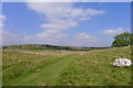
A large turf covered stone cairn situated at the north end of Lea Green above Grassington. It is situated on top of a small natural hillock. When it was excavated around 1893 it was found to have two circular walls within it, the outer 12 metres in diameter, the inner 5 metres.
A central circular grave pit was found containing a crouched skeleton lying on its right side with a 7.5cm long bone awl. This burial is likely to have been of early Bronze Age date. Three apparently secondary burials were found around the central burial and have been assigned an Iron Age date although now this is subject to doubt. Finds from the excavation are in the collections of the Craven Museum.
Source: Yorkshire Dales HER
You may be viewing yesterday's version of this page. To see the most up to date information please register for a free account.
Do not use the above information on other web sites or publications without permission of the contributor.
Nearby Images from Geograph Britain and Ireland:
©2015(licence)
©2013(licence)
©2014(licence)
©2018(licence)
©2015(licence)
The above images may not be of the site on this page, they are loaded from Geograph.
Please Submit an Image of this site or go out and take one for us!
Click here to see more info for this site
Nearby sites
Key: Red: member's photo, Blue: 3rd party photo, Yellow: other image, Green: no photo - please go there and take one, Grey: site destroyed
Download sites to:
KML (Google Earth)
GPX (GPS waypoints)
CSV (Garmin/Navman)
CSV (Excel)
To unlock full downloads you need to sign up as a Contributory Member. Otherwise downloads are limited to 50 sites.
Turn off the page maps and other distractions
Nearby sites listing. In the following links * = Image available
1.3km SE 143° Grassington Settlement Ancient Village or Settlement (SE0027765259)
1.4km SSE 163° Cove Hole* Cave or Rock Shelter (SD99896499)
1.9km ESE 115° Yarnbury Settlement (Grassington) Ancient Village or Settlement (SE012655)
2.1km SW 231° Brazen Gate* Round Cairn (SD9785964995)
2.1km ESE 115° Yarnbury Henge* Henge (SE0140665415)
2.2km NE 54° Green Hill Pasture Stone Circle* Stone Circle (SE013676)
2.2km WSW 244° Chapel House Wood* Ancient Village or Settlement (SD9750165316)
2.4km SSW 212° Little Wood* Ancient Village or Settlement (SD98266429)
3.0km E 84° Grassington A* Stone Circle (SE025666)
3.0km E 82° Grassington B* Stone Circle (SE025667)
3.2km SSE 161° Linton Churchyard Cross* Ancient Cross (SE0053963220)
3.3km SSE 163° The Linton Stones* Natural Stone / Erratic / Other Natural Feature (SE0042763177)
3.5km WSW 241° Heights Cave* Cave or Rock Shelter (SD96446460)
3.9km ESE 121° Mossy Moor Reservoir* Ring Cairn (SE02866432)
4.0km ESE 124° Dumpit Hill Enclosure Ancient Village or Settlement (SE0288464062)
4.2km ESE 124° Dumpit Hill* Stone Circle (SE02996399)
4.2km ESE 122° Dumpit Hill B (Hebden) Stone Circle (SE03076406)
4.2km W 261° Lantern Holes (Bordley)* Ancient Village or Settlement (SD95336566)
4.3km WSW 251° Hammond Close (Threshfield)* Ancient Village or Settlement (SD95386492)
4.5km WSW 256° Hammond Close Stone (Threshfield) Standing Stones (SD9516165209)
4.7km WSW 257° Druid's Altar (Yorkshire)* Stone Circle (SD94946527)
4.7km WNW 291° Kilnsey* Stone Circle (SD951680)
4.9km SSE 165° Ebolton Cave* Cave or Rock Shelter (SE008616)
5.0km WNW 301° Dowkerbottom Cave* Cave or Rock Shelter (SD95176889)
5.1km WNW 301° Douky Bottom Ring (Arncliffe) Ancient Village or Settlement (SD9512668887)
View more nearby sites and additional images


 We would like to know more about this location. Please feel free to add a brief description and any relevant information in your own language.
 Wir möchten mehr über diese Stätte erfahren. Bitte zögern Sie nicht, eine kurze Beschreibung und relevante Informationen in Deutsch hinzuzufügen.
 Nous aimerions en savoir encore un peu sur les lieux. S'il vous plaît n'hesitez pas à ajouter une courte description et tous les renseignements pertinents dans votre propre langue.
 Quisieramos informarnos un poco más de las lugares. No dude en añadir una breve descripción y otros datos relevantes en su propio idioma.