


<< Our Photo Pages >> Farnhill Moor (Kildwick) - Rock Art in England in Yorkshire (North)
Submitted by Anne T on Thursday, 21 February 2019 Page Views: 2063
Rock ArtSite Name: Farnhill Moor (Kildwick)Country: England
NOTE: This site is 1.351 km away from the location you searched for.
County: Yorkshire (North) Type: Rock Art
Nearest Town: Skipton Nearest Village: Kildwick / Farnhill
Map Ref: SE00644710
Latitude: 53.920041N Longitude: 1.991742W
Condition:
| 5 | Perfect |
| 4 | Almost Perfect |
| 3 | Reasonable but with some damage |
| 2 | Ruined but still recognisable as an ancient site |
| 1 | Pretty much destroyed, possibly visible as crop marks |
| 0 | No data. |
| -1 | Completely destroyed |
| 5 | Superb |
| 4 | Good |
| 3 | Ordinary |
| 2 | Not Good |
| 1 | Awful |
| 0 | No data. |
| 5 | Can be driven to, probably with disabled access |
| 4 | Short walk on a footpath |
| 3 | Requiring a bit more of a walk |
| 2 | A long walk |
| 1 | In the middle of nowhere, a nightmare to find |
| 0 | No data. |
| 5 | co-ordinates taken by GPS or official recorded co-ordinates |
| 4 | co-ordinates scaled from a detailed map |
| 3 | co-ordinates scaled from a bad map |
| 2 | co-ordinates of the nearest village |
| 1 | co-ordinates of the nearest town |
| 0 | no data |
Be the first person to rate this site - see the 'Contribute!' box in the right hand menu.
Internal Links:
External Links:
 (PID:193862)")
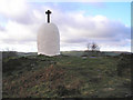
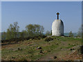
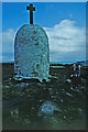
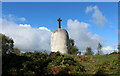
The Journal of Antiquities includes an entry for a cluster of cup-marked rocks in this area - see their page for Farnhill Moor Cup-Marked Rocks, Near Skipton, North Yorkshire. The Journal tells us these rocks are hidden in the undergrowth to the south side of the Jubilee Memorial (a white monument with a stone cross).
One of these large gritston rocks has four large cup marks with two smaller above, while the rock below it has forty or so cups.
The JoA gives directions on how to find these panels, although they note "you will have to search around to find these carvings, but it will be worth it in the end!"
Note: With thanks to Sunny100 for finding these panels; more information to follow
You may be viewing yesterday's version of this page. To see the most up to date information please register for a free account.
 (PID:193864)")
 (PID:193863)")
 (PID:193861)")
Do not use the above information on other web sites or publications without permission of the contributor.
Nearby Images from Geograph Britain and Ireland:
©2006(licence)
©2019(licence)

©2019(licence)
©2020(licence)
©2021(licence)
The above images may not be of the site on this page, they are loaded from Geograph.
Please Submit an Image of this site or go out and take one for us!
Click here to see more info for this site
Nearby sites
Key: Red: member's photo, Blue: 3rd party photo, Yellow: other image, Green: no photo - please go there and take one, Grey: site destroyed
Download sites to:
KML (Google Earth)
GPX (GPS waypoints)
CSV (Garmin/Navman)
CSV (Excel)
To unlock full downloads you need to sign up as a Contributory Member. Otherwise downloads are limited to 50 sites.
Turn off the page maps and other distractions
Nearby sites listing. In the following links * = Image available
488m NNE 28° Black Hill Round Cairn* Round Cairn (SE0087347529)
490m NNE 20° Black Hill Ring Cairn* Ring Cairn (SE00814756)
544m NNE 30° Bradley Long Cairn* Chambered Cairn (SE0091047573)
621m NNW 327° Hamblethorpe (Low Bradley)* Standing Stones (SE0030347622)
1.3km SSE 157° St Andrew, Kildwick, West Yorkshire* Ancient Cross (SE0114445893)
2.8km SE 146° Nanny's Grave (Steeton) Cairn (SE022448)
2.9km NNW 335° Low Snaygill Stone (Skipton) Rock Art (SD9939949729)
3.0km NNW 338° High Laithe Stone (17) Rock Art (SD9951649914)
3.5km NNW 344° Horse Close Hill (Skipton) Ancient Village or Settlement (SD9965350468)
3.5km WSW 256° Babyhouse Lane (Cononley) Ancient Village or Settlement (SD97194627)
3.6km NNW 344° Great Wood Laithe (19) Rock Art (SD9962050551)
3.8km SSE 150° Currer Woods Stone (Steeton)* Rock Art (SE02514384)
3.9km ESE 112° Silsden round barrow Round Barrow(s) (SE0426345622)
4.5km SE 139° Dragon Stone, Steeton* Rock Art (SE0359043677)
4.5km SE 139° Bowl Stone (Steeton) Rock Art (SE0359343673)
4.6km E 93° Haw 01* Rock Art (SE0520646856)
4.7km SE 133° The Kirk (Steeton) Natural Stone / Erratic / Other Natural Feature (SE041439)
4.8km SSE 166° Stinking Stone (Steeton) Standing Stone (Menhir) (SE0181442411)
4.9km NE 54° Counter Hill (31) Rock Art (SE0463049950)
4.9km NNW 341° Craven Museum* Museum (SD9902451734)
5.0km ENE 61° High Marchup (Silsden) Cairn (SE0501249489)
5.0km S 169° Sutton Stoop (Tarn Lane) Marker Stone (SE0161242146)
5.2km E 101° High Brunthwaite (32)* Rock Art (SE0576746143)
5.4km NE 56° Counter Hill (Addingham) Misc. Earthwork (SE051501)
5.4km S 191° Kid Stone (Sutton Moor) Natural Stone / Erratic / Other Natural Feature (SD9963141759)
View more nearby sites and additional images


 We would like to know more about this location. Please feel free to add a brief description and any relevant information in your own language.
 Wir möchten mehr über diese Stätte erfahren. Bitte zögern Sie nicht, eine kurze Beschreibung und relevante Informationen in Deutsch hinzuzufügen.
 Nous aimerions en savoir encore un peu sur les lieux. S'il vous plaît n'hesitez pas à ajouter une courte description et tous les renseignements pertinents dans votre propre langue.
 Quisieramos informarnos un poco más de las lugares. No dude en añadir una breve descripción y otros datos relevantes en su propio idioma.