


<< Our Photo Pages >> Santa Barbara Pyramid (2) - Pyramid / Mastaba in Spain in Canary Isles
Submitted by Klingon on Tuesday, 21 August 2007 Page Views: 5347
Multi-periodSite Name: Santa Barbara Pyramid (2)Country: Spain
NOTE: This site is 12.215 km away from the location you searched for.
Region: Canary Isles Type: Pyramid / Mastaba
Nearest Town: Icod des Los Vinos Nearest Village: Santa Barbara
Latitude: 28.371833N Longitude: 16.694844W
Condition:
| 5 | Perfect |
| 4 | Almost Perfect |
| 3 | Reasonable but with some damage |
| 2 | Ruined but still recognisable as an ancient site |
| 1 | Pretty much destroyed, possibly visible as crop marks |
| 0 | No data. |
| -1 | Completely destroyed |
| 5 | Superb |
| 4 | Good |
| 3 | Ordinary |
| 2 | Not Good |
| 1 | Awful |
| 0 | No data. |
| 5 | Can be driven to, probably with disabled access |
| 4 | Short walk on a footpath |
| 3 | Requiring a bit more of a walk |
| 2 | A long walk |
| 1 | In the middle of nowhere, a nightmare to find |
| 0 | No data. |
| 5 | co-ordinates taken by GPS or official recorded co-ordinates |
| 4 | co-ordinates scaled from a detailed map |
| 3 | co-ordinates scaled from a bad map |
| 2 | co-ordinates of the nearest village |
| 1 | co-ordinates of the nearest town |
| 0 | no data |
Internal Links:
External Links:
I have visited· I would like to visit
Klingon has visited here
 (PID:34692)")
You may be viewing yesterday's version of this page. To see the most up to date information please register for a free account.
Do not use the above information on other web sites or publications without permission of the contributor.
Nearby Images from Flickr
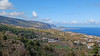
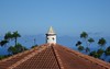
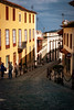
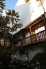
The above images may not be of the site on this page, but were taken nearby. They are loaded from Flickr so please click on them for image credits.
Click here to see more info for this site
Nearby sites
Click here to view sites on an interactive map of the areaKey: Red: member's photo, Blue: 3rd party photo, Yellow: other image, Green: no photo - please go there and take one, Grey: site destroyed
Download sites to:
KML (Google Earth)
GPX (GPS waypoints)
CSV (Garmin/Navman)
CSV (Excel)
To unlock full downloads you need to sign up as a Contributory Member. Otherwise downloads are limited to 50 sites.
Turn off the page maps and other distractions
Nearby sites listing. In the following links * = Image available
94m WSW 248° Santa Barbara Pyramid (1)* Pyramid / Mastaba
11.5km WSW 238° Zona Arqueologica Los Partidos de Franquis Rock Art
14.8km ENE 70° Museo Arqueológico del Puerto de la Cruz Museum
16.8km WSW 244° Pico Yeje Petroglifos Rock Art
18.8km SSW 202° Aripe Petroglifos Rock Art
18.9km ENE 78° Cueva de Bencomo Cave or Rock Shelter
25.7km ESE 107° Barranco de Badajoz Natural Stone / Erratic / Other Natural Feature
28.1km ESE 101° Güímar Pyramids* Pyramid / Mastaba
29.8km E 100° Cueva de Chinguaro Cave or Rock Shelter
31.9km S 176° Zona Arqueologica Roque de Vento Rock Art
32.0km E 94° Cueva de San Blas Cave or Rock Shelter
33.0km SSE 168° Dameros de San Miguel Petroglifos Rock Art
33.0km SSE 155° Zona arqueológica de Los Llanos de Ifara Rock Art
33.4km S 177° Zona Arqueologica Roque de Chijafe Rock Art
34.2km S 177° Roque de Igara Natural Stone / Erratic / Other Natural Feature
34.6km S 173° Zona Arqueológica Roque de la Abejera Rock Art
35.1km S 176° El Roque de Malpaso Rock Art
36.3km ENE 58° Cueva Jurada Natural Stone / Erratic / Other Natural Feature
37.9km ENE 62° Barranca Agua de Dios Natural Stone / Erratic / Other Natural Feature
41.1km S 180° Malpas de la Rasca Natural Stone / Erratic / Other Natural Feature
44.7km ENE 77° Museo de Naturaleza y Arqueología Museum
50.4km ENE 73° Cuevas de San Andrés Cave or Rock Shelter
64.6km WSW 242° La Fortaleza (Gomera) Natural Stone / Erratic / Other Natural Feature
95.3km ESE 115° Centro de Interpretación Los Caserones Museum
95.4km ESE 115° Lomo Caserones* Barrow Cemetery
View more nearby sites and additional images


 We would like to know more about this location. Please feel free to add a brief description and any relevant information in your own language.
 Wir möchten mehr über diese Stätte erfahren. Bitte zögern Sie nicht, eine kurze Beschreibung und relevante Informationen in Deutsch hinzuzufügen.
 Nous aimerions en savoir encore un peu sur les lieux. S'il vous plaît n'hesitez pas à ajouter une courte description et tous les renseignements pertinents dans votre propre langue.
 Quisieramos informarnos un poco más de las lugares. No dude en añadir una breve descripción y otros datos relevantes en su propio idioma.