


<< Other Photo Pages >> Lapakahi State Historical Park - Ancient Village or Settlement in United States in The West
Submitted by AKFisher on Monday, 04 September 2023 Page Views: 147
Pre-ColumbianSite Name: Lapakahi State Historical Park Alternative Name: Lapakahi Park, Lapa KahiCountry: United States
NOTE: This site is 9.355 km away from the location you searched for.
Region: The West Type: Ancient Village or Settlement
Nearest Town: Hawi, HI
Latitude: 20.175540N Longitude: 155.89718W
Condition:
| 5 | Perfect |
| 4 | Almost Perfect |
| 3 | Reasonable but with some damage |
| 2 | Ruined but still recognisable as an ancient site |
| 1 | Pretty much destroyed, possibly visible as crop marks |
| 0 | No data. |
| -1 | Completely destroyed |
| 5 | Superb |
| 4 | Good |
| 3 | Ordinary |
| 2 | Not Good |
| 1 | Awful |
| 0 | No data. |
| 5 | Can be driven to, probably with disabled access |
| 4 | Short walk on a footpath |
| 3 | Requiring a bit more of a walk |
| 2 | A long walk |
| 1 | In the middle of nowhere, a nightmare to find |
| 0 | No data. |
| 5 | co-ordinates taken by GPS or official recorded co-ordinates |
| 4 | co-ordinates scaled from a detailed map |
| 3 | co-ordinates scaled from a bad map |
| 2 | co-ordinates of the nearest village |
| 1 | co-ordinates of the nearest town |
| 0 | no data |
Internal Links:
External Links:
")
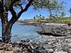
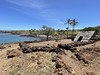
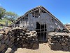
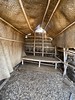
Lapakahi State Historical Park is a large area of ruins from an Ancient Hawaiian fishing village in the North Kohala District on the Big Island of Hawaiʻi.[2][3] Offshore is the Lapakahi Marine Life Conservation District.
The name lapa kahi means "single ridge" in the Hawaiian Language, and applied to the ahupuaʻa, an ancient land division that ran from the sea up to Kohala Mountain.[4] It is located off of ʻAkoni Pule Highway (Route 270), 12.4 miles (20.0 km) north of Kawaihae, Hawaii.[5] It is state archaeological site 10-02-2245,[6] and was added to the National Register of Historic Places on July 2, 1973, as site 73000654.[1] Just to the north, Māhukona Beach Park is on a bay where raw sugar from a local sugar mill was shipped to San Francisco.[7]. Source: Wikipedia.
References:
1. National Register Information System. National Register of Historic Places. National Park Service. July 9, 2010.
2. Lapakahi State Historical Park brochure on Hawaiʻi State Park web site
3. Archaeological Inventory Survey for a Road Realignment in Kohala T.S. Dye, January 2008
4. Lloyd J. Soehren (2010). "lookup of lapakahi ". in Hawaiian Place Names. Ulukau, the Hawaiian Electronic Library. Retrieved October 30, 2010.
5. Lapakahi State Historical Park. official Hawaii's State Park web site. Hawai'i Department of Land and Natural Resources. Retrieved November 4, 2018.
6. Historic sites in Hawaiʻi County on state web site
7. North Kohala map. Shoreline access. on official Hawaiʻi County web site. Archived from the original on July 8, 2011. Retrieved July 27, 2010.
Further reading and information:
Wikipedia
Hawaii DNR Division of State Parks
dlnr.hawaii.gov/dsp/parks/hawaii/lapakahi-state-historical-park/
Directions:
From Hawi, HI via HI-270, 7.3 mi.
You may be viewing yesterday's version of this page. To see the most up to date information please register for a free account.
")
")
Do not use the above information on other web sites or publications without permission of the contributor.
Nearby Images from Flickr


The above images may not be of the site on this page, but were taken nearby. They are loaded from Flickr so please click on them for image credits.
Click here to see more info for this site
Nearby sites
Click here to view sites on an interactive map of the areaKey: Red: member's photo, Blue: 3rd party photo, Yellow: other image, Green: no photo - please go there and take one, Grey: site destroyed
Download sites to:
KML (Google Earth)
GPX (GPS waypoints)
CSV (Garmin/Navman)
CSV (Excel)
To unlock full downloads you need to sign up as a Contributory Member. Otherwise downloads are limited to 50 sites.
Turn off the page maps and other distractions
Nearby sites listing. In the following links * = Image available
28.8km S 176° Waikoloa Petroglyph Field* Rock Art
60.6km S 190° 'Ahu'ena Heiau* Ancient Temple
70.8km NNW 348° Kahanu Garden and Preserve* Natural Stone / Erratic / Other Natural Feature
71.4km NNW 348° Pi'ilanihale Heiau Ancient Temple
127.4km SE 140° Pu'u Loa Petroglyphs* Rock Art
235.2km NW 305° Ulupō Heiau* Ancient Temple
277.5km NW 306° Pu'u O Mahuka* Ancient Temple
278.5km NW 307° Pupukea Beach Rock Art
284.6km WNW 302° Kaneana Cave* Cave or Rock Shelter
285.8km WNW 302° Ukanipo Heiau Ancient Temple
983.8km WNW 294° Mokumanamana* Stone Row / Alignment
3667.2km SSE 150° Temehea Tohua* Ancient Village or Settlement
3667.4km SSE 150° Taetae Tupuna He'e Tai* Museum
3720.1km NE 52° East Bay Walls* Stone Row / Alignment
3725.5km NE 48° Van Damme State Park Shellmounds* Artificial Mound
3738.9km NE 50° Bodega Head Shellmound* Artificial Mound
3740.2km NE 50° Bodega Harbor Shellmound* Artificial Mound
3740.4km NE 50° Duncans Landing Rockshelter* Cave or Rock Shelter
3758.6km NE 53° Sand Hill Bluff Shellmound* Artificial Mound
3765.8km NE 54° Monterey Indian Stone* Rock Art
3766.4km NE 49° Cloverdale Stone Rock Art
3768.5km NE 51° Ring Mountain Carving
3772.5km NE 53° Scotts Valley City Hall Artifact Display* Museum
3773.9km NE 45° Indian Island Shellmounds* Artificial Mound
3781.3km NE 51° Emeryville Shellmound* Artificial Mound
View more nearby sites and additional images


 We would like to know more about this location. Please feel free to add a brief description and any relevant information in your own language.
 Wir möchten mehr über diese Stätte erfahren. Bitte zögern Sie nicht, eine kurze Beschreibung und relevante Informationen in Deutsch hinzuzufügen.
 Nous aimerions en savoir encore un peu sur les lieux. S'il vous plaît n'hesitez pas à ajouter une courte description et tous les renseignements pertinents dans votre propre langue.
 Quisieramos informarnos un poco más de las lugares. No dude en añadir una breve descripción y otros datos relevantes en su propio idioma.