


<< Our Photo Pages >> Centro de Interpretación del Paisaje Cultural de Risco Caído y Montañas Sagradas - Museum in Spain in Canary Isles
Submitted by Klingon on Saturday, 26 August 2023 Page Views: 112
MuseumsSite Name: Centro de Interpretación del Paisaje Cultural de Risco Caído y Montañas SagradasCountry: Spain
NOTE: This site is 7.834 km away from the location you searched for.
Region: Canary Isles Type: Museum
Nearest Village: Artenara
Latitude: 28.020550N Longitude: 15.647492W
Condition:
| 5 | Perfect |
| 4 | Almost Perfect |
| 3 | Reasonable but with some damage |
| 2 | Ruined but still recognisable as an ancient site |
| 1 | Pretty much destroyed, possibly visible as crop marks |
| 0 | No data. |
| -1 | Completely destroyed |
| 5 | Superb |
| 4 | Good |
| 3 | Ordinary |
| 2 | Not Good |
| 1 | Awful |
| 0 | No data. |
| 5 | Can be driven to, probably with disabled access |
| 4 | Short walk on a footpath |
| 3 | Requiring a bit more of a walk |
| 2 | A long walk |
| 1 | In the middle of nowhere, a nightmare to find |
| 0 | No data. |
| 5 | co-ordinates taken by GPS or official recorded co-ordinates |
| 4 | co-ordinates scaled from a detailed map |
| 3 | co-ordinates scaled from a bad map |
| 2 | co-ordinates of the nearest village |
| 1 | co-ordinates of the nearest town |
| 0 | no data |
Internal Links:
External Links:
I have visited· I would like to visit
Klingon visited on 21st Jul 2023 - their rating: Cond: 5 Amb: 4 Access: 5
")
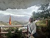
A museum, mainly dedicated to cave 6, which has been recreated here in great detail. The cave has a small hole in the ceiling, which allows a beam of light to fall on the cave walls. Markers show equinoxes and solstices.
Museum webpage
You may be viewing yesterday's version of this page. To see the most up to date information please register for a free account.
")
Do not use the above information on other web sites or publications without permission of the contributor.
Nearby Images from Flickr


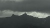
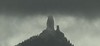
The above images may not be of the site on this page, but were taken nearby. They are loaded from Flickr so please click on them for image credits.
Click here to see more info for this site
Nearby sites
Click here to view sites on an interactive map of the areaKey: Red: member's photo, Blue: 3rd party photo, Yellow: other image, Green: no photo - please go there and take one, Grey: site destroyed
Download sites to:
KML (Google Earth)
GPX (GPS waypoints)
CSV (Garmin/Navman)
CSV (Excel)
To unlock full downloads you need to sign up as a Contributory Member. Otherwise downloads are limited to 50 sites.
Turn off the page maps and other distractions
Nearby sites listing. In the following links * = Image available
2.9km NNW 332° Risco Caído Cave or Rock Shelter
3.1km SSW 193° Cuevas del Rey* Cave or Rock Shelter
3.5km SSE 166° Roque Bentaiga* Cave or Rock Shelter
3.6km SSE 166° Centro de Interpretación del Roque Bentayga* Museum
3.7km WSW 243° Mesa de Acusa* Cave or Rock Shelter
6.5km SSE 148° Roque Nublo* Natural Stone / Erratic / Other Natural Feature
7.1km SSE 166° Chimirique* Cave or Rock Shelter
9.5km NNW 333° Necrópolis del Maipés de Agaete* Barrow Cemetery
12.0km SE 133° Humiaga* Ancient Temple
13.4km SE 142° Poblado de Tunte* Cave or Rock Shelter
13.7km N 357° Cueva Pintada* Ancient Village or Settlement
13.8km N 357° Museo y Parque Arqueológico (Gáldar)* Museum
13.8km NNE 18° Cenobio de Valeron* Cave or Rock Shelter
15.5km N 354° Bocabarranco* Ancient Village or Settlement
15.5km N 355° Poblado del Agujero* Ancient Village or Settlement
15.8km N 350° Mugaretes del Clavo* Ancient Village or Settlement
15.8km N 356° La Guancha* Ancient Village or Settlement
16.4km W 263° Poblado de Caserones* Ancient Village or Settlement
16.6km W 264° Lomo Caserones* Barrow Cemetery
16.7km W 264° Centro de Interpretación Los Caserones Museum
18.0km ESE 121° Guayadeque Valley* Cave or Rock Shelter
18.6km SE 143° Centro de Interpretación La Fortaleza* Museum
18.8km E 85° Cuevas de Bandama* Cave or Rock Shelter
19.0km ESE 121° Cueva Bermeja* Cave or Rock Shelter
19.3km SE 131° Audiencia* Cave or Rock Shelter
View more nearby sites and additional images


 We would like to know more about this location. Please feel free to add a brief description and any relevant information in your own language.
 Wir möchten mehr über diese Stätte erfahren. Bitte zögern Sie nicht, eine kurze Beschreibung und relevante Informationen in Deutsch hinzuzufügen.
 Nous aimerions en savoir encore un peu sur les lieux. S'il vous plaît n'hesitez pas à ajouter une courte description et tous les renseignements pertinents dans votre propre langue.
 Quisieramos informarnos un poco más de las lugares. No dude en añadir una breve descripción y otros datos relevantes en su propio idioma.