


<< Text Pages >> Arctic Henge - Modern Stone Circle etc in Iceland
Submitted by theCaptain on Tuesday, 01 May 2012 Page Views: 6923
Modern SitesSite Name: Arctic HengeCountry: Iceland
NOTE: This site is 40.368 km away from the location you searched for.
Type: Modern Stone Circle etc
Nearest Town: Husavik Nearest Village: Raufarhöfn
Latitude: 66.459300N Longitude: 15.9662W
Condition:
| 5 | Perfect |
| 4 | Almost Perfect |
| 3 | Reasonable but with some damage |
| 2 | Ruined but still recognisable as an ancient site |
| 1 | Pretty much destroyed, possibly visible as crop marks |
| 0 | No data. |
| -1 | Completely destroyed |
| 5 | Superb |
| 4 | Good |
| 3 | Ordinary |
| 2 | Not Good |
| 1 | Awful |
| 0 | No data. |
| 5 | Can be driven to, probably with disabled access |
| 4 | Short walk on a footpath |
| 3 | Requiring a bit more of a walk |
| 2 | A long walk |
| 1 | In the middle of nowhere, a nightmare to find |
| 0 | No data. |
| 5 | co-ordinates taken by GPS or official recorded co-ordinates |
| 4 | co-ordinates scaled from a detailed map |
| 3 | co-ordinates scaled from a bad map |
| 2 | co-ordinates of the nearest village |
| 1 | co-ordinates of the nearest town |
| 0 | no data |
Internal Links:
External Links:
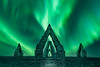
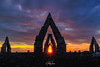
"Arctic Henge" has been built near the northern fishing village of Raufarhöfn in Iceland. It is aligned to the heavens to harness the Midnight Sun and is inspired by the mythical world of eddic poem Völuspá (Prophecy of the Seeress).
The Henge is 52m in diameter, and contains a Dvergar Path around the circumference linking the names of 72 dwarfs which form a year long cycle in which each Dvergar (dwarf) has five days.
A crystal at the top of a central 8-metre-high column will throw light all over the Henge.
See this document for details of its construction, and find your own birthday Dvergar or dwarf (mine is Loni, with God Heimdallur).
You may be viewing yesterday's version of this page. To see the most up to date information please register for a free account.
Do not use the above information on other web sites or publications without permission of the contributor.
Nearby Images from Flickr
The above images may not be of the site on this page, but were taken nearby. They are loaded from Flickr so please click on them for image credits.
Click here to see more info for this site
Nearby sites
Click here to view sites on an interactive map of the areaKey: Red: member's photo, Blue: 3rd party photo, Yellow: other image, Green: no photo - please go there and take one, Grey: site destroyed
Download sites to:
KML (Google Earth)
GPX (GPS waypoints)
CSV (Garmin/Navman)
CSV (Excel)
To unlock full downloads you need to sign up as a Contributory Member. Otherwise downloads are limited to 50 sites.
Turn off the page maps and other distractions
Nearby sites listing. In the following links * = Image available
8.7km NNW 344° Þorgeirsdys Cairn
125.9km SW 233° Eyjafjörður Fjord* Artificial Mound
179.9km SSE 150° Völvuleiði Cairn
236.5km WSW 245° Borgarvirki* Promontory Fort / Cliff Castle
311.6km SSW 199° Hildishaugur Cairn
315.7km SW 216° Þjóðveldisbærinn Ancient Village or Settlement
341.6km SW 227° Althing* Natural Stone / Erratic / Other Natural Feature
342.8km WSW 256° Flókatóftir Ancient Village or Settlement
346.4km WSW 246° Helgafell Natural Stone / Erratic / Other Natural Feature
347.6km SW 235° Skallagrimshaugur* Round Barrow(s)
347.9km SW 235° The Settlement Center Museum
362.6km SSW 202° Hjörleifshaugur Cairn
367.8km SSW 209° Rútshellir Cave or Rock Shelter
378.1km SW 230° Reykjavik Settlement Museum* Museum
411.8km SW 231° Vikingaheimar* Museum
609.8km NW 321° Danmark Ø Hut Foundations* Ancient Village or Settlement
644.7km SE 134° Viking longhouse Kvívík, Faeröer Ancient Village or Settlement
648.1km SE 132° Viking longhouse Leirvík, Faeröer Ancient Village or Settlement
861.9km NNW 337° Rendalen Hut Site* Ancient Village or Settlement
962.5km SE 143° North Ronan Crosses Ancient Cross (HW80913231)
967.6km SE 124° Pigeon Hellie Broch or Nuraghe (HP485062)
968.7km SE 125° Beorgs of Uyea neolithic axe factory* Ancient Mine, Quarry or other Industry (HU3268990052)
968.8km SE 125° Beorgs of Uyea chambered cairn* Chambered Cairn (HU3278890043)
969.4km SE 126° Loch of Houlland* Broch or Nuraghe (HU2140079160)
969.9km SE 126° Hamnavoe Broch* Broch or Nuraghe (HU2389380641)
View more nearby sites and additional images


 We would like to know more about this location. Please feel free to add a brief description and any relevant information in your own language.
 Wir möchten mehr über diese Stätte erfahren. Bitte zögern Sie nicht, eine kurze Beschreibung und relevante Informationen in Deutsch hinzuzufügen.
 Nous aimerions en savoir encore un peu sur les lieux. S'il vous plaît n'hesitez pas à ajouter une courte description et tous les renseignements pertinents dans votre propre langue.
 Quisieramos informarnos un poco más de las lugares. No dude en añadir una breve descripción y otros datos relevantes en su propio idioma.