Featured: How and why the ancients enchanted Great Britain and Brittany

How and why the ancients enchanted Great Britain and Brittany

Sacred Stones in Indian Civilization: with Special Reference to Megaliths

Sacred Stones in Indian Civilization: with Special Reference to Megaliths

Who's Online

There are currently, 219 guests and 1 members online.

You are a guest. To join in, please register for free by clicking here

Sponsors

<< Our Photo Pages >> Comox Estuary - Ancient Village or Settlement in Canada

Submitted by bat400 on Friday, 17 November 2006  Page Views: 10946

Multi-periodSite Name: Comox Estuary
Country: Canada
NOTE: This site is 4.002 km away from the location you searched for.

Type: Ancient Village or Settlement
Nearest Town: Comox, BC
Latitude: 49.675900N  Longitude: 124.9577W
Condition:
5Perfect
4Almost Perfect
3Reasonable but with some damage
2Ruined but still recognisable as an ancient site
1Pretty much destroyed, possibly visible as crop marks
0No data.
-1Completely destroyed
2 Ambience:
5Superb
4Good
3Ordinary
2Not Good
1Awful
0No data.
2 Access:
5Can be driven to, probably with disabled access
4Short walk on a footpath
3Requiring a bit more of a walk
2A long walk
1In the middle of nowhere, a nightmare to find
0No data.
2 Accuracy:
5co-ordinates taken by GPS or official recorded co-ordinates
4co-ordinates scaled from a detailed map
3co-ordinates scaled from a bad map
2co-ordinates of the nearest village
1co-ordinates of the nearest town
0no data
2

Internal Links:
External Links:

Comox Estuary
Comox Estuary submitted by Flickr : Looking out at the Straight of Georgia from the beach at Gibsons, BC, Canada - Feb 12 2014 Image copyright: swong95765, hosted on Flickr and displayed under the terms of their API. (Vote or comment on this photo)
Ancient Fish Traps and Clam Gardens in British Columbia. Many mudflats on tidal estuaries of the Johnstone Strait have evidence of wood and stone fish traps and clam gardens up to 1700 years old.

Wooden stakes, shaped by stone tools, were driven into the mudflats to form short stockade-like traps to catch fish as the tide went out. Over the passage of time the portions of abandoned traps that remained under the surface of the water covered mud have been preserved. Carbon dating indicates the same basic structures have been built and used up into historic times.
Clam gardens are terraced areas built so that sand is retained by rock walls, yet is still covered by water at each high tide.
The site location is only general for the area. There are many such sites near Comox.

Note: For more information see the article from the Campbell River Mirror.
You may be viewing yesterday's version of this page. To see the most up to date information please register for a free account.


Comox Estuary
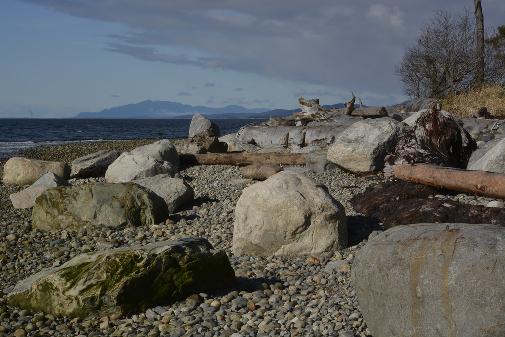
Comox Estuary submitted by TheDruid-3X3 : Site in Canada The Beach right out front of the Ancient Komoks Native Settlement. (Vote or comment on this photo)

Comox Estuary
Comox Estuary submitted by TheDruid-3X3 : Site in Canada The Beach at the Site of the Ancient Komoks Native Settlement going South. (Vote or comment on this photo)

Comox Estuary
Comox Estuary submitted by TheDruid-3X3 : Site in Canada Ancient Komoks Village Beach going North from the Site. (Vote or comment on this photo)

Comox Estuary
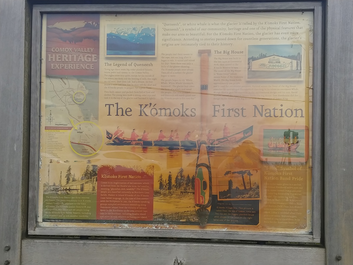
Comox Estuary submitted by TheDruid-3X3 : Site in Canada I-Hos Gallery Information Sign. (Vote or comment on this photo)

Comox Estuary
Comox Estuary submitted by TheDruid-3X3 : Site in Canada I-Hos Gallery Sign. (Vote or comment on this photo)

Comox Estuary
Comox Estuary submitted by TheDruid-3X3 : Site in Canada Komoks Exhibit Gallery on the Beach of the Komoks First Nation Reserve in the Comoks Estuary.

Comox Estuary
Comox Estuary submitted by TheDruid-3X3 : Site in Canada Aboriginal Longhouse that is built on the Site of the Komoks Native Reserve. Stopped in there while on my way to a Reunion with a High School Buddy who resides in Campbell River.

Do not use the above information on other web sites or publications without permission of the contributor.
Click here to see more info for this site

Nearby sites

Click here to view sites on an interactive map of the area

Key: Red: member's photo, Blue: 3rd party photo, Yellow: other image, Green: no photo - please go there and take one, Grey: site destroyed

Download sites to:
KML (Google Earth)
GPX (GPS waypoints)
CSV (Garmin/Navman)
CSV (Excel)

To unlock full downloads you need to sign up as a Contributory Member. Otherwise downloads are limited to 50 sites.


Turn off the page maps and other distractions

Nearby sites listing. In the following links * = Image available
 1.7km SSW 205° Comox Harbor Ancient Fish Trap* Ancient Mine, Quarry or other Industry
 35.5km ENE 60° Pictographs near Powell River ferry terminal Rock Art
 43.0km S 176° Sproat Lake Petroglyphs* Rock Art
 68.3km NNW 343° Ancient clam gardens on Quadra Island* Ancient Mine, Quarry or other Industry
 87.1km E 93° Salmon Inlet Barrow Cemetery
 89.9km ESE 104° shíshálh Nation tems swiya Museum Museum
 95.5km SE 128° Petroglyph Provincial Park (British Columbia)* Rock Art
 98.1km ESE 123° Lock Bay Site* Rock Art
 103.4km SE 126° Cedar by the Sea Petroglyphs* Rock Art
 107.8km ESE 123° Degnen Bay Site* Rock Art
 130.8km ESE 110° Museum of Anthropology - University of British Columbia* Museum
 136.4km ESE 107° Skalsh Rock* Rock Outcrop
 136.6km ESE 107° Coast Salish Stone Fish Weir* Stone Row / Alignment
 138.4km ESE 107° Xwayzway Village* Ancient Village or Settlement
 147.9km S 170° Makah Cultural and Research Center Museum
 152.6km ESE 118° Tsawwassen Long House Site* Ancient Village or Settlement
 156.8km ESE 111° Sewqueqsen Settlement at St.Mungo Cannery* Ancient Village or Settlement
 157.1km ESE 111° Glenrose Cannery* Ancient Village or Settlement
 168.5km S 174° Ozette Ancient Village or Settlement
 170.7km S 174° Wedding Rock* Rock Art
 172.3km ESE 114° P'Quals White Rock* Natural Stone / Erratic / Other Natural Feature
 185.1km SE 145° Race Rocks Ecological Reserve* Ring Cairn
 203.5km SSE 147° Tse-whit-zen Barrow Cemetery
 204.3km ESE 106° Xaytem Ancient Native Settlement* Ancient Village or Settlement
 212.6km ESE 108° Sumas Lightning Rock* Natural Stone / Erratic / Other Natural Feature
View more nearby sites and additional images

<< Withypool Circle

St Ninian's Isle >>

Please add your thoughts on this site

Lines on the Landscape, Circles from the Sky: Monuments of Neolithic Orkney

Lines on the Landscape, Circles from the Sky: Monuments of Neolithic Orkney

Sponsors

Auto-Translation (Google)

Translate from English into:

"Comox Estuary" | Login/Create an Account | 6 News and Comments
  
Go back to top of page    Comments are owned by the poster. We aren't responsible for their content.
Re: Comox Estuary by TheDruid-3X3 on Sunday, 22 October 2023
(User Info | Send a Message)

The Icon for this Site should be changed to Red as it now has a Member's Photo of it instead of 3rd Party Photo.
[ Reply to This ]

Re: Canadian Mudflats Record Thousand-Year-Old Fishing Secrets. by Andy B on Friday, 04 April 2014
(User Info | Send a Message)
I've found another of article about this:

The tide is going out at Gibsons Beach, in the Strait of Georgia on Canada’s west coast. When the tide is low, it’s easy to spot rock walls in the intertidal zone, the area of shore land that’s exposed during low tide and hidden when the tide is in. A person can look at this beach for years and never understand that apparently random scatterings of piled rocks were actually carefully constructed to catch food from the sea. One formation, a circular shape almost 100 feet in diameter, is a clam garden, a flattened area that pools water and creates a habitat for clams to grow. Nearby, also in the intertidal zone, is a chevron-shaped collection of stones that opens into the sea and funnels fish toward the shore, a fish trap.

Dana Lepofsky, an archaeologist at Simon Fraser University in Vancouver, British Columbia, believes these gardens and traps, found up and down the coast, could be up to 2,000 years old. They were used by the indigenous population and serve as artifacts that dispute what the archaeological record has to this point claimed was the area’s primary staple: salmon.

More at
http://archive.archaeology.org/1109/features/coast_salish_clam_gardens_salmon.html
[ Reply to This ]
    Re: Canadian Mudflats Record Thousand-Year-Old Fishing Secrets. by Andy B on Friday, 04 April 2014
    (User Info | Send a Message)
    And a few on fishtraps

    These Comox Harbour fishtraps are one of the wonders of British Columbia Archaeology.

    Incredibly, Nancy Greene has now recorded over 14,000 individual stakes spread over 19 fishtrap complexes in the harbour. The above shows just one of the plots of stakes, clearly delineating a highly-patterned and designed fishtrap – with several radiocarbon dates shown indicating a use-life of almost 1,000 years. Or, rather, a chevron-shaped trap seems to be built incrementally onto a heart-shaped one.

    http://qmackie.com/2010/05/12/more-on-comox-harbour-fishtraps/
    [ Reply to This ]
    Re: Canadian Mudflats Record Thousand-Year-Old Fishing Secrets. by Runemage on Saturday, 16 October 2021
    (User Info | Send a Message)
    Another account, by By Diane Selkirk, 14th October 2021

    It's interesting to read how different communities used different types of traps to make the most of the local resources.

    "What has surprised Norris over the years she's spent exploring the British Columbia coast is how the technologies differ from nation to nation yet are perfectly adapted to each location. While the K'ómoks People used stakes with lattice fences to manage and sustain what was once one of the region's most productive fish runs, in her own territory around the Gulf Islands, the Hul'q'umi'num and W̱SÁNEĆ People stacked rocks "like Tetris" to build low walls running parallel to the shore. These walls were designed to trap silt, which changed the slope of the beach to create "sea gardens" – large, flat inter-tidal areas that, once cleared of large rocks, were carefully tended to create the ideal habitat for clams, crab, sea cucumbers, rockfish, octopus, whelks and other marine life.

    In the winding inlets and islets of the Broughton Archipelago Provincial Park, the technology changes again. Here, the Kwakwaka'wakw People built monumental rock walls, large enough to be seen from space, to create the ideal water depth to encourage clam growth in the shallow bays. Norris says they also built the rock walls into spiral-shaped gardens that created flattened areas that could take advantage of the region’s unique swirling currents.

    Still further north, in the inner waterways and islands that make up part of Heiltsuk territory, Haíɫzaqv archaeologist Q̓íx̌itasu, also known as Elroy White, says his ancestors built stone-walled sea/clam gardens (called λápac̓i) and a wide variety of stone fish traps (called Ckvá) that were specifically designed depending on if they were "on a tidal flat, or in a creek or at the mouth of a river".

    "They were built so solidly that they wouldn't fall apart by actions of a river, or by the tide or if a canoe hit it," he said.

    For his thesis, "Heiltsuk Stone Fish Traps", White combined archaeology with oral history to gradually unravel the interconnection of rock-walled fish traps and his ancestors' relationship to salmon. He explained that when he began visiting the sites, he saw how the ancient fish trap technology and resource management system didn't just shape the tidal landscape, they shaped his culture and heritage."

    more
    https://www.bbc.com/travel/article/20211013-an-underwater-mystery-on-canadas-coast
    [ Reply to This ]

Canadian Mudflats Record Thousand-Year-Old Fishing Secrets. by bat400 on Friday, 17 November 2006
(User Info | Send a Message)
Mudflats yield archaeological secrets
By Alistair Taylor -- Nov 15 2006

Initially, I was reluctant to go to last week's presentation at the Museum at Campbell River.

It was a Wednesday night, a long day at work, even longer one the next day, maybe I should just stay home. But my son wanted to go to get some firsthand research for a school project on local First Nations culture, so off we went.

Man am I glad I went along. The presentation was on clam garden and fish trap research being conducted by the Hamatla Treaty Society (HTS). The presentation was done by anthropologist Deidre Cullon with some additional comments by archaeologist Bjorn Simonsen.

During the summer of 2006, the HTS conducted archaeological fieldwork in the Johnstone Strait and Comox areas. Prior to the fieldwork, fish traps had been documented throughout the Johnstone Strait and Comox areas but the HTS believed that there were others that had been overlooked by archaeologists. The HTS also believed that there were hundreds of clam gardens that were yet to be documented. Thus the focus of the fieldwork was the identification of fish traps and clam gardens.

During June and July 2006, when the tides were low, HTS crews and Cullon, Simonsen and geomorphologist John Harper surveyed beaches throughout Johnstone Strait. Dozens of fish trap complexes were identified and more than 100 new clam gardens were identified. The crews recorded the GPS locations of the traps and clam gardens, took photographs and, for the fish traps, collected numerous samples of fish trap stakes for study and radiocarbon dating.

The crews would travel to various sites in the Discovery Islands, usually inlets with mudflats at the mouths of rivers. There they sought out and uncovered the remaining stakes driven into the silt that formed the framework of fish traps used by local First Nations group to harvest salmon and the like. These sites would have hundreds of stakes, many of which were hundreds, and in some cases, thousands of years old. When they are pulled out of the mud, they look as fresh as if they were hacked at by a stone axe just months before. Sheared or worn off at the surface, the silt would preserve the remaining base of the post. These posts were as thin as a finger or as thick as a man's leg.

The posts were arranged in such a way that the tide would rise and the fish would swim into the traps which were basically like a corral or fence open at some point to the shore. The tide would go out and the fish swimming merrily inside the enclosure would not get out in time and be stranded inside at low tide. A simple but ingenious harvesting technique.

The surveyers would slosh around these mud flats looking for stakes and then take a GPS reading on every one in order to map it. Some of the flats were strewn with these things. Some were being uncovered by the channel of the river while others had to be dug out. Stakes were sent to Florida for radiocarbon dating and they prove hundreds of years of continuous use. That, of course, is the purpose behind all this; to prove continuous occupation of the areas for land claims. Cullon said that the government's position on land claims is that only land above the high tide mark can be claimed but First Nations lay claim to tidal areas as well because they were used for millennia. The fish traps and the clam gardens prove that -as if it really needs to be proven. It's only the most obvious thing in the world that people living off the "land" around here would harvest clams and other shellfish.

The clam gardens are interesting as well. These are areas of clam beaches where the people would clear the beach rocks away and stack them into a low wall that followed the line of the beach on the water side, often for hundreds of meters. The result was a terrace of beach sand that increased the productivity of the beach in terms of clam production upwards of 400 per cent.

We also got to see in the presentation a little bit

Read the rest of this post...
[ Reply to This ]
    Re: Canadian Mudflats Record Thousand-Year-Old Fishing Secrets. by bat400 on Friday, 17 November 2006
    (User Info | Send a Message)
    I really liked this article both for its charm and the obvious enjoyment this man got out of learning something about the history of this area that was new to him.
    [ Reply to This ]

Your Name: Anonymous [ Register Now ]
Subject:


Add your comment or contribution to this page. Spam or offensive posts are deleted immediately, don't even bother

<<< What is five plus one as a number? (Please type the answer to this question in the little box on the left)
You can also embed videos and other things. For Youtube please copy and paste the 'embed code'.
For Google Street View please include Street View in the text.
Create a web link like this: <a href="https://www.megalithic.co.uk">This is a link</a>  

Allowed HTML is:
<p> <b> <i> <a> <img> <em> <br> <strong> <blockquote> <tt> <li> <ol> <ul> <object> <param> <embed> <iframe>

We would like to know more about this location. Please feel free to add a brief description and any relevant information in your own language.
Wir möchten mehr über diese Stätte erfahren. Bitte zögern Sie nicht, eine kurze Beschreibung und relevante Informationen in Deutsch hinzuzufügen.
Nous aimerions en savoir encore un peu sur les lieux. S'il vous plaît n'hesitez pas à ajouter une courte description et tous les renseignements pertinents dans votre propre langue.
Quisieramos informarnos un poco más de las lugares. No dude en añadir una breve descripción y otros datos relevantes en su propio idioma.