


<< Text Pages >> Fort Rock Cave - Cave or Rock Shelter in United States
Submitted by bat400 on Monday, 08 January 2007 Page Views: 9422
Natural PlacesSite Name: Fort Rock CaveCountry: United States
NOTE: This site is 203.596 km away from the location you searched for.
Type: Cave or Rock Shelter
Nearest Town: Bend, OR
Latitude: 43.378000N Longitude: 121.069W
Condition:
| 5 | Perfect |
| 4 | Almost Perfect |
| 3 | Reasonable but with some damage |
| 2 | Ruined but still recognisable as an ancient site |
| 1 | Pretty much destroyed, possibly visible as crop marks |
| 0 | No data. |
| -1 | Completely destroyed |
| 5 | Superb |
| 4 | Good |
| 3 | Ordinary |
| 2 | Not Good |
| 1 | Awful |
| 0 | No data. |
| 5 | Can be driven to, probably with disabled access |
| 4 | Short walk on a footpath |
| 3 | Requiring a bit more of a walk |
| 2 | A long walk |
| 1 | In the middle of nowhere, a nightmare to find |
| 0 | No data. |
| 5 | co-ordinates taken by GPS or official recorded co-ordinates |
| 4 | co-ordinates scaled from a detailed map |
| 3 | co-ordinates scaled from a bad map |
| 2 | co-ordinates of the nearest village |
| 1 | co-ordinates of the nearest town |
| 0 | no data |
Be the first person to rate this site - see the 'Contribute!' box in the right hand menu.
Internal Links:
External Links:
Cave or Rock Shelter in Lake County, Oregon
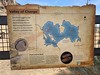
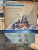
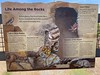
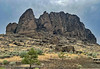
Thousands of years ago the massive rock outcrop known as Fort Rock jutted above the surface of an inland sea. And more than 6000 years ago ancient man took up residence in a rock shelter here, paddling between "the Rock" and the mainland. Here people set up housekeeping, leaving hearths, stone tools, and a cache of sandals woven from sagebrush - reputed to be the oldest examples of footwear from the ancient world.
When the site was first excavated its great age was indicated by artifacts found beneath a volcano ash layer already dated to 6000 years ago. Man-made artifacts found here dated back as early as 7000 BC. Now the rock shelter may be visited on guided tours held two weekends each month. Details are the State Park website:
Description of site and details on visiting the site.
The location given here is only approximate for the cave itself.
[Information from the film "Ancient America: Nomads of the West," Dir./Prod. Gray Warriner, 1997, among others.]
You may be viewing yesterday's version of this page. To see the most up to date information please register for a free account.
Do not use the above information on other web sites or publications without permission of the contributor.
Nearby Images from Flickr
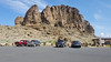

The above images may not be of the site on this page, but were taken nearby. They are loaded from Flickr so please click on them for image credits.
Click here to see more info for this site
Nearby sites
Click here to view sites on an interactive map of the areaKey: Red: member's photo, Blue: 3rd party photo, Yellow: other image, Green: no photo - please go there and take one, Grey: site destroyed
Download sites to:
KML (Google Earth)
GPX (GPS waypoints)
CSV (Garmin/Navman)
CSV (Excel)
To unlock full downloads you need to sign up as a Contributory Member. Otherwise downloads are limited to 50 sites.
Turn off the page maps and other distractions
Nearby sites listing. In the following links * = Image available
14.0km ENE 79° Cougar Mountain Cave Cave or Rock Shelter
80.4km SSE 148° Paisley Caves* Cave or Rock Shelter
97.5km N 355° Redmond Lava Caves Cave or Rock Shelter
143.8km SE 128° Petroglyph Lake Rock Art
167.4km SE 138° Lake County Rock art Rock Art
207.5km E 84° Stinkingwater Medicine Wheels* Stone Circle
211.7km ESE 123° Catlow Cave Cave or Rock Shelter
224.1km SSW 206° Pluto's Cave* Cave or Rock Shelter
237.6km SSW 203° Mount Shasta* Natural Stone / Erratic / Other Natural Feature
251.7km N 359° Columbia Hills State Park* Rock Art
258.4km N 5° Maryhill Stonehenge* Modern Stone Circle etc
259.4km N 355° Lower Memaloose Island* Barrow Cemetery
270.1km NNW 332° Portland Art Museum* Museum
313.8km NNE 25° Matalam Ancient Village or Settlement
350.4km NNE 25° Columbia Park* Ancient Village or Settlement
367.7km E 90° Celebration Park (Idaho)* Rock Art
374.8km NNE 14° Whale Island Petroglyphs Rock Art
380.1km ENE 61° Hells Canyon Archeological District* Rock Art
382.8km SW 223° Indian Island Shellmounds* Artificial Mound
388.8km SSE 157° Winnemucca Lake Petroglyphs* Rock Art
405.8km NNE 12° Vantage Petroglyphs* Rock Art
413.5km ENE 57° Snake River Archaeological Site* Rock Art
429.1km NNW 349° Skystone* Natural Stone / Erratic / Other Natural Feature
433.2km SSE 150° Lovelock Cave* Cave or Rock Shelter
448.2km NNW 342° Qwu?gwes Ancient Village or Settlement
View more nearby sites and additional images


 We would like to know more about this location. Please feel free to add a brief description and any relevant information in your own language.
 Wir möchten mehr über diese Stätte erfahren. Bitte zögern Sie nicht, eine kurze Beschreibung und relevante Informationen in Deutsch hinzuzufügen.
 Nous aimerions en savoir encore un peu sur les lieux. S'il vous plaît n'hesitez pas à ajouter une courte description et tous les renseignements pertinents dans votre propre langue.
 Quisieramos informarnos un poco más de las lugares. No dude en añadir una breve descripción y otros datos relevantes en su propio idioma.