


<< Text Pages >> Whale Island Petroglyphs - Rock Art in United States in The West
Submitted by bat400 on Saturday, 15 December 2007 Page Views: 10465
Rock ArtSite Name: Whale Island Petroglyphs Alternative Name: Priest Rapids DamCountry: United States Region: The West Type: Rock Art
Nearest Town: Yakima, WA Nearest Village: Desrt Aire, WA
Latitude: 46.646900N Longitude: 119.9061W
Condition:
| 5 | Perfect |
| 4 | Almost Perfect |
| 3 | Reasonable but with some damage |
| 2 | Ruined but still recognisable as an ancient site |
| 1 | Pretty much destroyed, possibly visible as crop marks |
| 0 | No data. |
| -1 | Completely destroyed |
| 5 | Superb |
| 4 | Good |
| 3 | Ordinary |
| 2 | Not Good |
| 1 | Awful |
| 0 | No data. |
| 5 | Can be driven to, probably with disabled access |
| 4 | Short walk on a footpath |
| 3 | Requiring a bit more of a walk |
| 2 | A long walk |
| 1 | In the middle of nowhere, a nightmare to find |
| 0 | No data. |
| 5 | co-ordinates taken by GPS or official recorded co-ordinates |
| 4 | co-ordinates scaled from a detailed map |
| 3 | co-ordinates scaled from a bad map |
| 2 | co-ordinates of the nearest village |
| 1 | co-ordinates of the nearest town |
| 0 | no data |
Internal Links:
External Links:
Rock Art in Kittitas County, Washington.
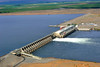
The petroglyphs from Whale Island in the Columbia River were removed to this spot before the dam was built at Priest Rapids.
The rock art of ancient cultures can be found in many sites in the Columbia River Gorge.
The petroglyphs appear to be on display at the Priest Rapids Dam picnic area.
Note: Joint Wanapum Nation and Washington State Police Patrol deters looters from Columbia River ancient sites.
You may be viewing yesterday's version of this page. To see the most up to date information please register for a free account.
Do not use the above information on other web sites or publications without permission of the contributor.
Nearby Images from Flickr

The above images may not be of the site on this page, but were taken nearby. They are loaded from Flickr so please click on them for image credits.
Click here to see more info for this site
Nearby sites
Click here to view sites on an interactive map of the areaKey: Red: member's photo, Blue: 3rd party photo, Yellow: other image, Green: no photo - please go there and take one, Grey: site destroyed
Download sites to:
KML (Google Earth)
GPX (GPS waypoints)
CSV (Garmin/Navman)
CSV (Excel)
To unlock full downloads you need to sign up as a Contributory Member. Otherwise downloads are limited to 50 sites.
Turn off the page maps and other distractions
Nearby sites listing. In the following links * = Image available
34.4km NNW 348° Vantage Petroglyphs* Rock Art
73.8km SE 129° Columbia Park* Ancient Village or Settlement
91.5km SSE 152° Matalam Ancient Village or Settlement
126.6km SSW 214° Maryhill Stonehenge* Modern Stone Circle etc
145.0km SW 220° Columbia Hills State Park* Rock Art
152.3km SW 227° Lower Memaloose Island* Barrow Cemetery
181.2km NNE 13° Balance Rock Omak* Natural Stone / Erratic / Other Natural Feature
182.8km WNW 289° Skystone* Natural Stone / Erratic / Other Natural Feature
213.9km WNW 303° Burke Museum of Natural History and Culture* Museum
221.5km NE 54° Indian Painted Rocks (Spokane) Rock Art
222.0km E 98° Red Elk Rock Shelter* Rock Art
232.3km WNW 302° Haleets* Rock Art
236.1km WNW 286° Qwu?gwes Ancient Village or Settlement
248.4km WSW 241° Portland Art Museum* Museum
282.0km ESE 106° Cooper's Ferry Archaeological Site* Ancient Village or Settlement
284.0km SSW 201° Redmond Lava Caves Cave or Rock Shelter
290.5km ESE 119° Snake River Archaeological Site* Rock Art
300.6km SE 127° Hells Canyon Archeological District* Rock Art
312.3km NE 46° Priest Lake Pictographs Rock Art
314.6km WNW 303° Tse-whit-zen Barrow Cemetery
317.6km NNW 329° Sumas Lightning Rock* Natural Stone / Erratic / Other Natural Feature
328.7km NW 305° Race Rocks Ecological Reserve* Ring Cairn
328.8km NNW 329° Xaytem Ancient Native Settlement* Ancient Village or Settlement
341.1km NW 322° P'Quals White Rock* Natural Stone / Erratic / Other Natural Feature
356.1km NW 319° Tsawwassen Long House Site* Ancient Village or Settlement
View more nearby sites and additional images


 We would like to know more about this location. Please feel free to add a brief description and any relevant information in your own language.
 Wir möchten mehr über diese Stätte erfahren. Bitte zögern Sie nicht, eine kurze Beschreibung und relevante Informationen in Deutsch hinzuzufügen.
 Nous aimerions en savoir encore un peu sur les lieux. S'il vous plaît n'hesitez pas à ajouter une courte description et tous les renseignements pertinents dans votre propre langue.
 Quisieramos informarnos un poco más de las lugares. No dude en añadir una breve descripción y otros datos relevantes en su propio idioma.