


<< Our Photo Pages >> Balance Rock Omak - Natural Stone / Erratic / Other Natural Feature in United States
Submitted by AlexAssa on Saturday, 25 May 2019 Page Views: 3021
Natural PlacesSite Name: Balance Rock OmakCountry: United States
NOTE: This site is 226.039 km away from the location you searched for.
Type: Natural Stone / Erratic / Other Natural Feature
Nearest Town: Omak
Latitude: 48.235199N Longitude: 119.367244W
Condition:
| 5 | Perfect |
| 4 | Almost Perfect |
| 3 | Reasonable but with some damage |
| 2 | Ruined but still recognisable as an ancient site |
| 1 | Pretty much destroyed, possibly visible as crop marks |
| 0 | No data. |
| -1 | Completely destroyed |
| 5 | Superb |
| 4 | Good |
| 3 | Ordinary |
| 2 | Not Good |
| 1 | Awful |
| 0 | No data. |
| 5 | Can be driven to, probably with disabled access |
| 4 | Short walk on a footpath |
| 3 | Requiring a bit more of a walk |
| 2 | A long walk |
| 1 | In the middle of nowhere, a nightmare to find |
| 0 | No data. |
| 5 | co-ordinates taken by GPS or official recorded co-ordinates |
| 4 | co-ordinates scaled from a detailed map |
| 3 | co-ordinates scaled from a bad map |
| 2 | co-ordinates of the nearest village |
| 1 | co-ordinates of the nearest town |
| 0 | no data |
Internal Links:
External Links:
")
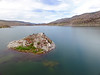
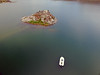
Sacred balancing stone of lake Omak. Located in the southern part of the lake, about a kilometer from the shore.
Megalithica.ru
You may be viewing yesterday's version of this page. To see the most up to date information please register for a free account.
")
")
Do not use the above information on other web sites or publications without permission of the contributor.
Nearby Images from Flickr


The above images may not be of the site on this page, but were taken nearby. They are loaded from Flickr so please click on them for image credits.
Click here to see more info for this site
Nearby sites
Click here to view sites on an interactive map of the areaKey: Red: member's photo, Blue: 3rd party photo, Yellow: other image, Green: no photo - please go there and take one, Grey: site destroyed
Download sites to:
KML (Google Earth)
GPX (GPS waypoints)
CSV (Garmin/Navman)
CSV (Excel)
To unlock full downloads you need to sign up as a Contributory Member. Otherwise downloads are limited to 50 sites.
Turn off the page maps and other distractions
Nearby sites listing. In the following links * = Image available
148.0km ESE 109° Indian Painted Rocks (Spokane) Rock Art
150.8km SSW 199° Vantage Petroglyphs* Rock Art
181.2km SSW 193° Whale Island Petroglyphs Rock Art
188.1km ENE 78° Priest Lake Pictographs Rock Art
224.1km S 176° Columbia Park* Ancient Village or Settlement
226.0km WNW 295° Sumas Lightning Rock* Natural Stone / Erratic / Other Natural Feature
228.2km WSW 255° Burke Museum of Natural History and Culture* Museum
234.9km WNW 297° Xaytem Ancient Native Settlement* Ancient Village or Settlement
243.3km WSW 241° Skystone* Natural Stone / Erratic / Other Natural Feature
243.4km WSW 258° Haleets* Rock Art
257.4km S 180° Matalam Ancient Village or Settlement
267.1km WNW 290° P'Quals White Rock* Natural Stone / Erratic / Other Natural Feature
274.2km SE 139° Red Elk Rock Shelter* Rock Art
281.4km WNW 293° Glenrose Cannery* Ancient Village or Settlement
281.6km WNW 293° Sewqueqsen Settlement at St.Mungo Cannery* Ancient Village or Settlement
288.3km WNW 289° Tsawwassen Long House Site* Ancient Village or Settlement
289.1km WSW 248° Qwu?gwes Ancient Village or Settlement
300.2km WNW 295° Xwayzway Village* Ancient Village or Settlement
302.0km WNW 295° Coast Salish Stone Fish Weir* Stone Row / Alignment
302.2km WNW 295° Skalsh Rock* Rock Outcrop
302.9km SSW 202° Maryhill Stonehenge* Modern Stone Circle etc
303.9km W 269° Tse-whit-zen Barrow Cemetery
307.6km WNW 293° Museum of Anthropology - University of British Columbia* Museum
308.4km W 273° Race Rocks Ecological Reserve* Ring Cairn
317.2km SSW 205° Columbia Hills State Park* Rock Art
View more nearby sites and additional images


 We would like to know more about this location. Please feel free to add a brief description and any relevant information in your own language.
 Wir möchten mehr über diese Stätte erfahren. Bitte zögern Sie nicht, eine kurze Beschreibung und relevante Informationen in Deutsch hinzuzufügen.
 Nous aimerions en savoir encore un peu sur les lieux. S'il vous plaît n'hesitez pas à ajouter une courte description et tous les renseignements pertinents dans votre propre langue.
 Quisieramos informarnos un poco más de las lugares. No dude en añadir una breve descripción y otros datos relevantes en su propio idioma.