


<< Our Photo Pages >> Agua Fria National Monument - Badger Springs Wash - Rock Art in United States in The Southwest
Submitted by bat400 on Monday, 21 August 2023 Page Views: 330
Rock ArtSite Name: Agua Fria National Monument - Badger Springs WashCountry: United States
NOTE: This site is 6.347 km away from the location you searched for.
Region: The Southwest Type: Rock Art
Nearest Town: Sedona Nearest Village: Black Canyon City
Latitude: 34.223000N Longitude: 112.093W
Condition:
| 5 | Perfect |
| 4 | Almost Perfect |
| 3 | Reasonable but with some damage |
| 2 | Ruined but still recognisable as an ancient site |
| 1 | Pretty much destroyed, possibly visible as crop marks |
| 0 | No data. |
| -1 | Completely destroyed |
| 5 | Superb |
| 4 | Good |
| 3 | Ordinary |
| 2 | Not Good |
| 1 | Awful |
| 0 | No data. |
| 5 | Can be driven to, probably with disabled access |
| 4 | Short walk on a footpath |
| 3 | Requiring a bit more of a walk |
| 2 | A long walk |
| 1 | In the middle of nowhere, a nightmare to find |
| 0 | No data. |
| 5 | co-ordinates taken by GPS or official recorded co-ordinates |
| 4 | co-ordinates scaled from a detailed map |
| 3 | co-ordinates scaled from a bad map |
| 2 | co-ordinates of the nearest village |
| 1 | co-ordinates of the nearest town |
| 0 | no data |
Internal Links:
External Links:
I have visited· I would like to visit
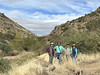
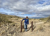
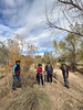
bat400 visited on 1st Mar 2023 - their rating: Cond: 3 Amb: 4 Access: 3 I visited on a weekday morning in overcast conditions. In March the vegetation is not as thick as it appears to get later in the year. The trail from the trail head rapidly becomes the spring itself, and although there are places along the left hand bank heading down to the site, You are likely to get your feet wet if there has been recent rain in the area.
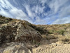
This is a beautiful site, with a large pool at the confluence. At this point the Agua Fria canyon is not particularly deep, but at other locations the river is cut deeply into the mesa.
")
The Badger Springs Wash trail can be used to access petroglyph panels at the confluence of the springs and the Agua Fria River. The trailhead has a parking area and can be reached by any passenger car from the I-17 exit. The trail is approximately 1 mile long, and mostly along the spring wash itself and is often wet with a sandy bottom. The Agua Fria River canyon is the home of petroglyphs and pueblo sites dating back as much as 2000 years. As many as 450 distinct archaeological sites have been recorded. The National Monument is managed by the Bureau of Land Management. See the
Agua Fria website for more information on access: http://www.blm.gov/visit/agua-fria
You may be viewing yesterday's version of this page. To see the most up to date information please register for a free account.
")
")
Do not use the above information on other web sites or publications without permission of the contributor.
Nearby Images from Flickr
The above images may not be of the site on this page, but were taken nearby. They are loaded from Flickr so please click on them for image credits.
Click here to see more info for this site
Nearby sites
Click here to view sites on an interactive map of the areaKey: Red: member's photo, Blue: 3rd party photo, Yellow: other image, Green: no photo - please go there and take one, Grey: site destroyed
Download sites to:
KML (Google Earth)
GPX (GPS waypoints)
CSV (Garmin/Navman)
CSV (Excel)
To unlock full downloads you need to sign up as a Contributory Member. Otherwise downloads are limited to 50 sites.
Turn off the page maps and other distractions
Nearby sites listing. In the following links * = Image available
2.4km NW 316° Agua Fria National Monument* Rock Art
33.9km SSE 154° Skull Mesa* Ancient Village or Settlement
36.8km E 86° Goat Camp Ruin Ancient Village or Settlement
49.0km NNE 28° Montezuma Castle* Ancient Village or Settlement
56.8km NNE 33° Montezuma Well* Ancient Village or Settlement
57.4km ENE 70° V/V* Rock Art
58.1km SSW 192° Palo Verde Ancient Village or Settlement
60.9km S 185° Deer Valley Petroglyph Preserve* Rock Art
61.0km N 6° Tuzigoot Monument* Ancient Village or Settlement
70.1km NNE 20° Red Rock State Park* Ancient Village or Settlement
79.0km NNE 13° Palatki* Rock Art
80.7km SSW 209° White Tank Mountains Petroglyphs* Rock Art
85.7km S 171° Desert Botanical Gardens* Museum
86.9km S 173° Pueblo Grande - Ball Court* Ancient Village or Settlement
87.1km S 173° Pueblo Grande* Ancient Village or Settlement
87.4km S 173° Pueblo Grande - Park of Four Waters Ancient Village or Settlement
88.5km S 171° Loma del Rio Ruins* Ancient Village or Settlement
89.6km S 171° Hayden Butte* Rock Art
90.3km SSE 163° Park of the Canals Ancient Village or Settlement
90.6km SSE 165° Mesa Grande Ancient Village or Settlement
92.8km SSE 165° Arizona Museum of Natural History* Museum
97.0km S 179° South Mountain Rock Art
110.9km SE 125° Tonto National Monument* Ancient Village or Settlement
116.5km N 3° Keyhole Sink* Rock Art
118.3km NNE 27° Walnut Canyon Nat. Mon.* Ancient Village or Settlement
View more nearby sites and additional images


 We would like to know more about this location. Please feel free to add a brief description and any relevant information in your own language.
 Wir möchten mehr über diese Stätte erfahren. Bitte zögern Sie nicht, eine kurze Beschreibung und relevante Informationen in Deutsch hinzuzufügen.
 Nous aimerions en savoir encore un peu sur les lieux. S'il vous plaît n'hesitez pas à ajouter une courte description et tous les renseignements pertinents dans votre propre langue.
 Quisieramos informarnos un poco más de las lugares. No dude en añadir una breve descripción y otros datos relevantes en su propio idioma.