

, Aubrey Burl")
<< Text Pages >> South Mountain - Rock Art in United States in The Southwest
Submitted by bat400 on Saturday, 21 July 2007 Page Views: 4650
Rock ArtSite Name: South MountainCountry: United States
NOTE: This site is 2.186 km away from the location you searched for.
Region: The Southwest Type: Rock Art
Nearest Town: Phoenix, AZ
Latitude: 33.350550N Longitude: 112.07572W
Condition:
| 5 | Perfect |
| 4 | Almost Perfect |
| 3 | Reasonable but with some damage |
| 2 | Ruined but still recognisable as an ancient site |
| 1 | Pretty much destroyed, possibly visible as crop marks |
| 0 | No data. |
| -1 | Completely destroyed |
| 5 | Superb |
| 4 | Good |
| 3 | Ordinary |
| 2 | Not Good |
| 1 | Awful |
| 0 | No data. |
| 5 | Can be driven to, probably with disabled access |
| 4 | Short walk on a footpath |
| 3 | Requiring a bit more of a walk |
| 2 | A long walk |
| 1 | In the middle of nowhere, a nightmare to find |
| 0 | No data. |
| 5 | co-ordinates taken by GPS or official recorded co-ordinates |
| 4 | co-ordinates scaled from a detailed map |
| 3 | co-ordinates scaled from a bad map |
| 2 | co-ordinates of the nearest village |
| 1 | co-ordinates of the nearest town |
| 0 | no data |
Be the first person to rate this site - see the 'Contribute!' box in the right hand menu.
Internal Links:
External Links:
Rock Art in Maricopa County, Arizona.
South Mountain Park is best known for its Sonoran Desert trails and an abundance of petroglyphs scattered throughout the 16000 acre city park. There are also several Hohokam village and settlement sites.
There is a visitor center and marked trails, several of which are wheelchair accessible. The location given is or the visitor's center. Park website.
Note: Highway Plans May Detour Around Arizona Hohokam site. See comment.
You may be viewing yesterday's version of this page. To see the most up to date information please register for a free account.
Do not use the above information on other web sites or publications without permission of the contributor.
Nearby Images from Flickr
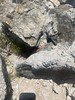
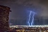
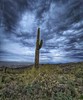
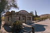
The above images may not be of the site on this page, but were taken nearby. They are loaded from Flickr so please click on them for image credits.
Click here to see more info for this site
Nearby sites
Click here to view sites on an interactive map of the areaKey: Red: member's photo, Blue: 3rd party photo, Yellow: other image, Green: no photo - please go there and take one, Grey: site destroyed
Download sites to:
KML (Google Earth)
GPX (GPS waypoints)
CSV (Garmin/Navman)
CSV (Excel)
To unlock full downloads you need to sign up as a Contributory Member. Otherwise downloads are limited to 50 sites.
Turn off the page maps and other distractions
Nearby sites listing. In the following links * = Image available
13.2km NE 39° Pueblo Grande - Park of Four Waters Ancient Village or Settlement
13.5km NE 39° Pueblo Grande* Ancient Village or Settlement
13.7km NE 38° Pueblo Grande - Ball Court* Ancient Village or Settlement
15.7km ENE 56° Hayden Butte* Rock Art
15.9km NE 53° Loma del Rio Ruins* Ancient Village or Settlement
17.4km NE 44° Desert Botanical Gardens* Museum
23.3km ENE 66° Mesa Grande Ancient Village or Settlement
23.6km ENE 72° Arizona Museum of Natural History* Museum
26.3km ENE 67° Park of the Canals Ancient Village or Settlement
37.0km N 349° Deer Valley Petroglyph Preserve* Rock Art
42.2km NNW 342° Palo Verde Ancient Village or Settlement
48.3km WNW 303° White Tank Mountains Petroglyphs* Rock Art
63.8km SE 128° Casa Grande - Ball Court* Ancient Village or Settlement
63.8km SE 128° Casa Grande - The Great House* Ancient Palace
63.9km SE 128° Casa Grande - Village* Ancient Village or Settlement
67.9km NNE 11° Skull Mesa* Ancient Village or Settlement
95.1km ENE 70° Tonto National Monument* Ancient Village or Settlement
97.0km N 359° Agua Fria National Monument - Badger Springs Wash* Rock Art
97.5km WSW 248° Chamber of the Sun* Rock Art
97.6km WSW 248° Painted Rock Petroglyph Site* Rock Art
98.8km N 358° Agua Fria National Monument* Rock Art
105.5km NNE 19° Goat Camp Ruin Ancient Village or Settlement
115.4km E 96° Crow Canyon* Rock Art
127.9km NNE 24° V/V* Rock Art
129.0km WSW 249° Sears Point* Rock Art
View more nearby sites and additional images


 We would like to know more about this location. Please feel free to add a brief description and any relevant information in your own language.
 Wir möchten mehr über diese Stätte erfahren. Bitte zögern Sie nicht, eine kurze Beschreibung und relevante Informationen in Deutsch hinzuzufügen.
 Nous aimerions en savoir encore un peu sur les lieux. S'il vous plaît n'hesitez pas à ajouter une courte description et tous les renseignements pertinents dans votre propre langue.
 Quisieramos informarnos un poco más de las lugares. No dude en añadir una breve descripción y otros datos relevantes en su propio idioma.