


<< Image Pages >> Rochester Rock Art Panel - Rock Art in United States in The West
Submitted by AKFisher on Monday, 07 August 2023 Page Views: 145
Rock ArtSite Name: Rochester Rock Art Panel Alternative Name: Rochester Petroglyphs, Rochester Panel, Rochester Petroglyphs SiteCountry: United States
NOTE: This site is 37.965 km away from the location you searched for.
Region: The West Type: Rock Art
Nearest Town: Emery, UT
Latitude: 38.903360N Longitude: 111.19801W
Condition:
| 5 | Perfect |
| 4 | Almost Perfect |
| 3 | Reasonable but with some damage |
| 2 | Ruined but still recognisable as an ancient site |
| 1 | Pretty much destroyed, possibly visible as crop marks |
| 0 | No data. |
| -1 | Completely destroyed |
| 5 | Superb |
| 4 | Good |
| 3 | Ordinary |
| 2 | Not Good |
| 1 | Awful |
| 0 | No data. |
| 5 | Can be driven to, probably with disabled access |
| 4 | Short walk on a footpath |
| 3 | Requiring a bit more of a walk |
| 2 | A long walk |
| 1 | In the middle of nowhere, a nightmare to find |
| 0 | No data. |
| 5 | co-ordinates taken by GPS or official recorded co-ordinates |
| 4 | co-ordinates scaled from a detailed map |
| 3 | co-ordinates scaled from a bad map |
| 2 | co-ordinates of the nearest village |
| 1 | co-ordinates of the nearest town |
| 0 | no data |
Internal Links:
External Links:
")
From Wikipedia:
Rochester Rock Art Panel
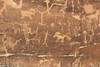
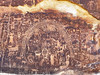
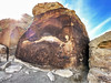
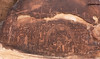
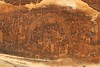
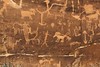
The Rochester Rock Art Panel in Emery County, Utah consists of a large number of petroglyphs of various ages. Some are prehistoric rock art, probably of Fremont culture origin. Others are probably modern, depicting horses, for example. And some are perhaps of very recent origin, most likely the work of white explorers, settlers, and/or tourists. There is a great deal of graffiti near the main panel that is obviously of fairly recent origin. The majority of the panel is covered with a dark desert varnish which contrasts nicely with the light sandstone that is exposed when the petroglyphs are pecked into the surface. There are several sections of very light stone in the center of the panel where it appears some of original stone was removed, probably by collectors who were after the figures inscribed there.
Further reading and information:
Wikipedia
https://en.wikipedia.org/wiki/Rochester_Rock_Art_Panel
Red Rock Adventure.com
https://redrockadventure.com/rock-art-ancient-ruins/635-rochester-rock-art
Directions:
The panel is located 3 miles east of Emery, Utah but is accessed via a graded road coming from a turnoff to the north, near the town of Moore. To get to the panel drive to the turnoff between mile markers 16 and 17 on highway 10 between the towns of Emery and Ferron. Take the paved road heading east to Moore for about half a mile. Turn south onto a well-graded road and drive for about 4 miles, passing a radio tower on the way. From the parking lot an obvious hiking trail of about a half mile leads along the side of a small canyon to the panel.
You may be viewing yesterday's version of this page. To see the most up to date information please register for a free account.
Do not use the above information on other web sites or publications without permission of the contributor.
Nearby Images from Flickr
The above images may not be of the site on this page, but were taken nearby. They are loaded from Flickr so please click on them for image credits.
Click here to see more info for this site
Nearby sites
Click here to view sites on an interactive map of the areaKey: Red: member's photo, Blue: 3rd party photo, Yellow: other image, Green: no photo - please go there and take one, Grey: site destroyed
Download sites to:
KML (Google Earth)
GPX (GPS waypoints)
CSV (Garmin/Navman)
CSV (Excel)
To unlock full downloads you need to sign up as a Contributory Member. Otherwise downloads are limited to 50 sites.
Turn off the page maps and other distractions
Nearby sites listing. In the following links * = Image available
67.2km E 86° Black Dragon Canyon* Rock Art
68.5km S 183° Fruita Petroglyphs* Rock Art
99.4km ESE 120° Great Gallery Horseshoe Canyon* Rock Art
99.5km ESE 120° Alcove Gallery Rock Art
99.6km ESE 119° Horseshoe Gallery Rock Art
99.8km ESE 119° High Gallery Rock Art
103.4km NE 56° Range Creek Ancient Village or Settlement
105.0km WSW 250° Fremont Indian State Park* Museum
112.1km S 190° Anasazi Indian State Park* Ancient Village or Settlement
114.0km W 278° Devil's Kitchen Area Rock Art
123.4km ESE 104° Bartlett Pictographs Rock Art
129.3km ESE 116° Mesa Arch* Natural Stone / Erratic / Other Natural Feature
129.7km NE 39° Nine Mile Canyon* Rock Art
130.8km ESE 102° Intestine Man rock paintings Rock Art
132.9km SSW 199° North Creek Shelter Cave or Rock Shelter
136.4km E 94° Dark Angel Pictographs A Rock Art
136.4km E 94° Dark Angel Petroglyphs B Rock Art
136.5km E 94° Dark Angel Monolith Natural Stone / Erratic / Other Natural Feature
138.3km E 95° Landscape Arch* Natural Stone / Erratic / Other Natural Feature
143.3km E 99° Balanced Rock Arches* Natural Stone / Erratic / Other Natural Feature
143.9km ESE 106° Poison Spider petroglyphs Rock Art
144.0km ESE 103° Courthouse Wash Rock Art* Rock Art
144.2km ESE 106° Potash Road petroglyphs* Rock Art
144.8km ESE 107° Birthing Rock petroglyphs* Rock Art
145.0km ESE 105° Moonflower Petroglyphs* Rock Art
View more nearby sites and additional images


 We would like to know more about this location. Please feel free to add a brief description and any relevant information in your own language.
 Wir möchten mehr über diese Stätte erfahren. Bitte zögern Sie nicht, eine kurze Beschreibung und relevante Informationen in Deutsch hinzuzufügen.
 Nous aimerions en savoir encore un peu sur les lieux. S'il vous plaît n'hesitez pas à ajouter une courte description et tous les renseignements pertinents dans votre propre langue.
 Quisieramos informarnos un poco más de las lugares. No dude en añadir una breve descripción y otros datos relevantes en su propio idioma.