


<< Our Photo Pages >> Balanced Rock Arches - Natural Stone / Erratic / Other Natural Feature in United States in The Southwest
Submitted by KaiHofmann on Monday, 21 November 2022 Page Views: 519
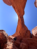
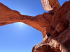
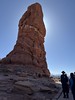
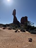
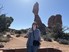
Natural PlacesSite Name: Balanced Rock ArchesCountry: United States
NOTE: This site is 1.966 km away from the location you searched for.
Region: The Southwest Type: Natural Stone / Erratic / Other Natural Feature
Nearest Town: Moab
Latitude: 38.700938N Longitude: 109.564624W
Condition:
| 5 | Perfect |
| 4 | Almost Perfect |
| 3 | Reasonable but with some damage |
| 2 | Ruined but still recognisable as an ancient site |
| 1 | Pretty much destroyed, possibly visible as crop marks |
| 0 | No data. |
| -1 | Completely destroyed |
| 5 | Superb |
| 4 | Good |
| 3 | Ordinary |
| 2 | Not Good |
| 1 | Awful |
| 0 | No data. |
| 5 | Can be driven to, probably with disabled access |
| 4 | Short walk on a footpath |
| 3 | Requiring a bit more of a walk |
| 2 | A long walk |
| 1 | In the middle of nowhere, a nightmare to find |
| 0 | No data. |
| 5 | co-ordinates taken by GPS or official recorded co-ordinates |
| 4 | co-ordinates scaled from a detailed map |
| 3 | co-ordinates scaled from a bad map |
| 2 | co-ordinates of the nearest village |
| 1 | co-ordinates of the nearest town |
| 0 | no data |
Internal Links:
External Links:
")
About 39m tall rock formation with a balanced rock up on the base.
You may be viewing yesterday's version of this page. To see the most up to date information please register for a free account.
Do not use the above information on other web sites or publications without permission of the contributor.
Nearby Images from Flickr
The above images may not be of the site on this page, but were taken nearby. They are loaded from Flickr so please click on them for image credits.
Click here to see more info for this site
Nearby sites
Click here to view sites on an interactive map of the areaKey: Red: member's photo, Blue: 3rd party photo, Yellow: other image, Green: no photo - please go there and take one, Grey: site destroyed
Download sites to:
KML (Google Earth)
GPX (GPS waypoints)
CSV (Garmin/Navman)
CSV (Excel)
To unlock full downloads you need to sign up as a Contributory Member. Otherwise downloads are limited to 50 sites.
Turn off the page maps and other distractions
Nearby sites listing. In the following links * = Image available
2.4km ESE 116° Double Arch* Natural Stone / Erratic / Other Natural Feature
3.2km ESE 122° North Window Arch* Natural Stone / Erratic / Other Natural Feature
5.7km NE 44° Wolf Ranch Petroglyphs* Rock Art
7.4km NE 50° Delicate Arch* Natural Stone / Erratic / Other Natural Feature
10.5km S 188° Courthouse Wash Rock Art* Rock Art
10.6km NNW 340° Landscape Arch* Natural Stone / Erratic / Other Natural Feature
12.3km NNW 333° Dark Angel Pictographs A Rock Art
12.4km NNW 334° Dark Angel Petroglyphs B Rock Art
12.4km NNW 334° Dark Angel Monolith Natural Stone / Erratic / Other Natural Feature
15.1km WSW 247° Intestine Man rock paintings Rock Art
16.5km S 187° Moonflower Petroglyphs* Rock Art
17.7km S 190° Potash Road petroglyphs* Rock Art
19.0km SSW 192° Poison Spider petroglyphs Rock Art
19.6km SSE 158° Moab Golf Course Rock Art Site Rock Art
20.2km S 189° Birthing Rock petroglyphs* Rock Art
23.2km WSW 251° Bartlett Pictographs Rock Art
43.4km SW 217° Mesa Arch* Natural Stone / Erratic / Other Natural Feature
61.1km WSW 244° High Gallery Rock Art
61.2km WSW 245° Horseshoe Gallery Rock Art
62.1km WSW 244° Alcove Gallery Rock Art
63.1km WSW 244° Great Gallery Horseshoe Canyon* Rock Art
71.9km SSW 192° Thirteen Faces Pictographs Rock Art
78.9km WNW 290° Black Dragon Canyon* Rock Art
79.4km S 177° Newspaper Rock State Park* Rock Art
94.3km SSE 168° Manti-La Sal National Forest* Ancient Village or Settlement
View more nearby sites and additional images


 We would like to know more about this location. Please feel free to add a brief description and any relevant information in your own language.
 Wir möchten mehr über diese Stätte erfahren. Bitte zögern Sie nicht, eine kurze Beschreibung und relevante Informationen in Deutsch hinzuzufügen.
 Nous aimerions en savoir encore un peu sur les lieux. S'il vous plaît n'hesitez pas à ajouter une courte description et tous les renseignements pertinents dans votre propre langue.
 Quisieramos informarnos un poco más de las lugares. No dude en añadir una breve descripción y otros datos relevantes en su propio idioma.