


<< Our Photo Pages >> Valley of the Shields - Rock Art in United States in The Northwest Mountains
Submitted by JulieRyder on Thursday, 14 January 2016 Page Views: 6819
Rock ArtSite Name: Valley of the ShieldsCountry: United States
NOTE: This site is 19.814 km away from the location you searched for.
Region: The Northwest Mountains Type: Rock Art
Nearest Town: Billings, Montana Nearest Village: Bridger, Montana
Latitude: 45.343558N Longitude: 108.915144W
Condition:
| 5 | Perfect |
| 4 | Almost Perfect |
| 3 | Reasonable but with some damage |
| 2 | Ruined but still recognisable as an ancient site |
| 1 | Pretty much destroyed, possibly visible as crop marks |
| 0 | No data. |
| -1 | Completely destroyed |
| 5 | Superb |
| 4 | Good |
| 3 | Ordinary |
| 2 | Not Good |
| 1 | Awful |
| 0 | No data. |
| 5 | Can be driven to, probably with disabled access |
| 4 | Short walk on a footpath |
| 3 | Requiring a bit more of a walk |
| 2 | A long walk |
| 1 | In the middle of nowhere, a nightmare to find |
| 0 | No data. |
| 5 | co-ordinates taken by GPS or official recorded co-ordinates |
| 4 | co-ordinates scaled from a detailed map |
| 3 | co-ordinates scaled from a bad map |
| 2 | co-ordinates of the nearest village |
| 1 | co-ordinates of the nearest town |
| 0 | no data |
Be the first person to rate this site - see the 'Contribute!' box in the right hand menu.
Internal Links:
External Links:
")
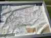
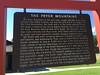
Valley of the Shields is the largest polychrome pictograph site in North America with 110 panels discovered so far. It is the Pryor Mountains in Carbon County, Montana. According to Leon Secatero, a Navajo Elder, this glyph named Changing of the Worlds is read from right to left and represents the story of the first three worlds. The Fourth and Fifth World are in order below and on the next panel. http://www.galacticfacets.com/ancient-pictographs.html
You may be viewing yesterday's version of this page. To see the most up to date information please register for a free account.
Do not use the above information on other web sites or publications without permission of the contributor.
Nearby Images from Flickr
The above images may not be of the site on this page, but were taken nearby. They are loaded from Flickr so please click on them for image credits.
Click here to see more info for this site
Nearby sites
Click here to view sites on an interactive map of the areaKey: Red: member's photo, Blue: 3rd party photo, Yellow: other image, Green: no photo - please go there and take one, Grey: site destroyed
Download sites to:
KML (Google Earth)
GPX (GPS waypoints)
CSV (Garmin/Navman)
CSV (Excel)
To unlock full downloads you need to sign up as a Contributory Member. Otherwise downloads are limited to 50 sites.
Turn off the page maps and other distractions
Nearby sites listing. In the following links * = Image available
49.5km SE 139° Petroglyph Canyon (Cowley)* Rock Art
57.7km NE 41° Pictograph Caves* Rock Art
96.9km SE 126° Bighorn Medicine Wheel* Stone Circle
117.5km SSW 214° Mummy Cave* Cave or Rock Shelter
151.7km SW 229° Yellowstone Lake* Ancient Village or Settlement
153.7km WSW 248° Obsidian Cliff* Ancient Mine, Quarry or other Industry
158.9km SE 137° Medicine Lodge State Archeological Site* Rock Art
173.6km S 172° Legend Rock* Rock Art
220.5km SSW 195° High Rise Village Ancient Village or Settlement
269.7km WNW 301° Megaliths Of Helena* Natural Stone / Erratic / Other Natural Feature
287.8km SSE 158° Castle Gardens* Rock Art
310.5km NW 321° First Peoples Buffalo Jump* Natural Stone / Erratic / Other Natural Feature
342.1km ESE 103° Devil's Tower National Monument* Natural Stone / Erratic / Other Natural Feature
351.6km ESE 107° Arch Creek Petroglyphs* Rock Art
366.0km SE 138° Glenrock Buffalo Jump* Natural Stone / Erratic / Other Natural Feature
385.0km S 184° White Mountain Wyoming* Rock Art
385.1km ESE 102° Vore Buffalo Jump* Natural Stone / Erratic / Other Natural Feature
463.0km NNW 335° Writing-on-Stone Provincial Park* Rock Art
473.9km SE 132° Hell Gap* Ancient Village or Settlement
489.9km N 349° Stampede Site* Ancient Mine, Quarry or other Industry
495.2km WSW 243° Shoshone Ice Caves* Cave or Rock Shelter
505.8km WSW 242° Idaho's Mammoth Cave* Cave or Rock Shelter
508.1km ESE 122° Hudson-Meng Bison Kill* Ancient Mine, Quarry or other Industry
509.9km WSW 238° Wilson Butte Cave Cave or Rock Shelter
531.6km SW 214° Great Salt Lake Cave* Cave or Rock Shelter
View more nearby sites and additional images


 We would like to know more about this location. Please feel free to add a brief description and any relevant information in your own language.
 Wir möchten mehr über diese Stätte erfahren. Bitte zögern Sie nicht, eine kurze Beschreibung und relevante Informationen in Deutsch hinzuzufügen.
 Nous aimerions en savoir encore un peu sur les lieux. S'il vous plaît n'hesitez pas à ajouter une courte description et tous les renseignements pertinents dans votre propre langue.
 Quisieramos informarnos un poco más de las lugares. No dude en añadir una breve descripción y otros datos relevantes en su propio idioma.