


<< Text Pages >> Paquime - Ancient Village or Settlement in Mexico
Submitted by bat400 on Tuesday, 10 November 2009 Page Views: 5709
Multi-periodSite Name: Paquime Alternative Name: Casas GrandesCountry: Mexico
NOTE: This site is 62.42 km away from the location you searched for.
Type: Ancient Village or Settlement
Nearest Town: Nuevo Casas Grandes Nearest Village: Casas Grandes
Latitude: 30.366700N Longitude: 107.9474W
Condition:
| 5 | Perfect |
| 4 | Almost Perfect |
| 3 | Reasonable but with some damage |
| 2 | Ruined but still recognisable as an ancient site |
| 1 | Pretty much destroyed, possibly visible as crop marks |
| 0 | No data. |
| -1 | Completely destroyed |
| 5 | Superb |
| 4 | Good |
| 3 | Ordinary |
| 2 | Not Good |
| 1 | Awful |
| 0 | No data. |
| 5 | Can be driven to, probably with disabled access |
| 4 | Short walk on a footpath |
| 3 | Requiring a bit more of a walk |
| 2 | A long walk |
| 1 | In the middle of nowhere, a nightmare to find |
| 0 | No data. |
| 5 | co-ordinates taken by GPS or official recorded co-ordinates |
| 4 | co-ordinates scaled from a detailed map |
| 3 | co-ordinates scaled from a bad map |
| 2 | co-ordinates of the nearest village |
| 1 | co-ordinates of the nearest town |
| 0 | no data |
Internal Links:
External Links:
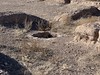
Ancient Village in Chihuahua, Mexico.Pacquime first experienced substantial construction of post, wattle and daub construction in the 1100's. But in the 1300's, after the general abandonment of Chaco Canyon site to the north, a construction boom occurred in Pacquime, possibly in as little as ten years. Single story dwellings were replaced by multistory apartment blocks made from adobe bricks.
More than 2000 rooms were built and the population possible exceeded 2000, even in a desert climate that required a canal system to grow adequate crops.
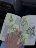
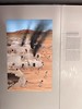
The site contains ball courts, earthen mounds, and plazas. A museum shows artifacts found at the site.
Note: First Evidence of Corn Beer in northern Mexico Discovered on Teeth From Ancient Burials. See comment.
You may be viewing yesterday's version of this page. To see the most up to date information please register for a free account.
Do not use the above information on other web sites or publications without permission of the contributor.
Nearby Images from Flickr

The above images may not be of the site on this page, but were taken nearby. They are loaded from Flickr so please click on them for image credits.
Click here to see more info for this site
Nearby sites
Click here to view sites on an interactive map of the areaKey: Red: member's photo, Blue: 3rd party photo, Yellow: other image, Green: no photo - please go there and take one, Grey: site destroyed
Download sites to:
KML (Google Earth)
GPX (GPS waypoints)
CSV (Garmin/Navman)
CSV (Excel)
To unlock full downloads you need to sign up as a Contributory Member. Otherwise downloads are limited to 50 sites.
Turn off the page maps and other distractions
Nearby sites listing. In the following links * = Image available
93.1km W 278° Arroyo el Concho* Cave or Rock Shelter
93.2km SSW 193° Madera Caves Cave or Rock Shelter
93.2km SSW 193° Valley of the Caves, Chihuahua* Cave or Rock Shelter
193.8km NE 42° Caballo Blanco de Juárez Hill Figure or Geoglyph
250.6km NE 46° Hueco Tanks State Park & Historic Site* Rock Art
251.8km WNW 303° Murray Springs* Ancient Village or Settlement
261.5km NNE 24° Summerford Mountain Archaeology District Rock Art
304.4km WNW 295° Patagonia Lake State Park Petroglyphs* Rock Art
311.3km NNE 29° Fossilized Footprints - White Sands National Park* Ancient Trackway
319.8km N 355° Gila Cliff Dwellings* Ancient Village or Settlement
344.0km W 271° Cerro De Trincheras* Ancient Village or Settlement
352.7km WSW 237° La Pintada Rock Art
362.8km NW 310° Romero Ruins* Ancient Village or Settlement
367.1km NW 307° Las Capas* Ancient Village or Settlement
367.6km NW 310° Vista de la Montana UMC* Modern Stone Circle etc
373.2km NNW 347° Cordova Cave* Cave or Rock Shelter
374.3km NW 308° Marana Village Site* Ancient Village or Settlement
376.4km NW 306° Signal Hill* Rock Art
378.3km NNE 28° Three Rivers Petroglyphs* Rock Art
394.6km N 352° Tularosa cave* Cave or Rock Shelter
420.4km NW 320° Crow Canyon* Rock Art
431.7km NNW 333° Kinishba Ruins* Ancient Village or Settlement
440.2km NNW 344° Casa Malpais* Ancient Village or Settlement
448.0km NW 312° Casa Grande - Village* Ancient Village or Settlement
448.1km NW 312° Casa Grande - The Great House* Ancient Palace
View more nearby sites and additional images


 We would like to know more about this location. Please feel free to add a brief description and any relevant information in your own language.
 Wir möchten mehr über diese Stätte erfahren. Bitte zögern Sie nicht, eine kurze Beschreibung und relevante Informationen in Deutsch hinzuzufügen.
 Nous aimerions en savoir encore un peu sur les lieux. S'il vous plaît n'hesitez pas à ajouter une courte description et tous les renseignements pertinents dans votre propre langue.
 Quisieramos informarnos un poco más de las lugares. No dude en añadir una breve descripción y otros datos relevantes en su propio idioma.