


<< Other Photo Pages >> Chaco Culture NHP - Tsin Kletzin - Ancient Village or Settlement in United States in The Southwest
Submitted by bat400 on Sunday, 27 May 2012 Page Views: 2051
Multi-periodSite Name: Chaco Culture NHP - Tsin Kletzin Alternative Name: 29SJ385,LA 40385Country: United States Region: The Southwest Type: Ancient Village or Settlement
Nearest Town: Farmington, NM Nearest Village: Cuba, NM
Latitude: 36.036300N Longitude: 107.9578W
Condition:
| 5 | Perfect |
| 4 | Almost Perfect |
| 3 | Reasonable but with some damage |
| 2 | Ruined but still recognisable as an ancient site |
| 1 | Pretty much destroyed, possibly visible as crop marks |
| 0 | No data. |
| -1 | Completely destroyed |
| 5 | Superb |
| 4 | Good |
| 3 | Ordinary |
| 2 | Not Good |
| 1 | Awful |
| 0 | No data. |
| 5 | Can be driven to, probably with disabled access |
| 4 | Short walk on a footpath |
| 3 | Requiring a bit more of a walk |
| 2 | A long walk |
| 1 | In the middle of nowhere, a nightmare to find |
| 0 | No data. |
| 5 | co-ordinates taken by GPS or official recorded co-ordinates |
| 4 | co-ordinates scaled from a detailed map |
| 3 | co-ordinates scaled from a bad map |
| 2 | co-ordinates of the nearest village |
| 1 | co-ordinates of the nearest town |
| 0 | no data |
Internal Links:
External Links:
")
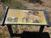
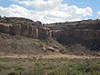
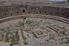
The Great House is unexcavated. You can reach the site on the South Mesa Hiking Trail.
[Information from National Park Service website describing the South Mesa hiking trail, and the Chaco Research Archive - Tsin Kletsin.]
You may be viewing yesterday's version of this page. To see the most up to date information please register for a free account.
")
Do not use the above information on other web sites or publications without permission of the contributor.
Nearby Images from Flickr
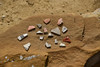
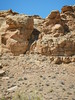
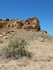
The above images may not be of the site on this page, but were taken nearby. They are loaded from Flickr so please click on them for image credits.
Click here to see more info for this site
Nearby sites
Click here to view sites on an interactive map of the areaKey: Red: member's photo, Blue: 3rd party photo, Yellow: other image, Green: no photo - please go there and take one, Grey: site destroyed
Download sites to:
KML (Google Earth)
GPX (GPS waypoints)
CSV (Garmin/Navman)
CSV (Excel)
To unlock full downloads you need to sign up as a Contributory Member. Otherwise downloads are limited to 50 sites.
Turn off the page maps and other distractions
Nearby sites listing. In the following links * = Image available
2.1km N 354° Chaco Culture NHP - Casa Rinconada* Ancient Temple
2.7km N 7° Chaco Culture NHP - Chetro Ketl* Ancient Village or Settlement
2.7km N 353° Chaco Culture NHP - Pueblo Bonito* Ancient Village or Settlement
2.8km NNW 346° Chaco Culture NHP - Pueblo del Arroyo* Ancient Village or Settlement
3.0km ENE 58° Chaco Culture NHP - Hungo Pavi* Ancient Village or Settlement
3.4km NNW 341° Chaco Culture NHP - Kin Kletso* Ancient Village or Settlement
3.7km N 357° Chaco Culture NHP - New Alto* Ancient Village or Settlement
3.7km N 0° Chaco Culture NHP - Pueblo Alto* Ancient Village or Settlement
4.1km E 94° Chaco Culture NHP - Una Vida* Ancient Village or Settlement
4.2km E 93° Chaco Culture NHP - Una Vida Petroglyph site* Rock Art
4.7km ESE 114° Chaco Culture NHP- Fajada Butte* Rock Art
5.3km NNW 328° Chaco Culture NHP - Penasco Blanco Trail Petroglyphs* Rock Art
6.4km NW 324° Chaco Culture NHP - Supernova pictograph* Rock Art
6.5km NW 321° Chaco Culture NHP - Peñasco Blanco* Ancient Village or Settlement
7.8km E 83° Chaco Culture NHP* Ancient Village or Settlement
8.0km E 98° Chaco Culture NHP - Wijiji Ancient Village or Settlement
10.4km W 265° Chaco Culture NHP - Kin Klizhin* Ancient Village or Settlement
16.9km WSW 258° Kin Bineola* Ancient Village or Settlement
26.4km ESE 104° Pueblo Pintado* Ancient Village or Settlement
42.5km SSW 199° Kin Ya'a* Ancient Village or Settlement
66.5km S 184° Blue J Ancient Village or Settlement
68.4km S 187° Casamero* Ancient Village or Settlement
74.2km N 355° Salmon Ruins* Ancient Village or Settlement
88.8km N 358° Aztec Ruins National Monument* Ancient Village or Settlement
91.5km NNE 17° Simon Canyon Ruins* Ancient Village or Settlement
View more nearby sites and additional images


 We would like to know more about this location. Please feel free to add a brief description and any relevant information in your own language.
 Wir möchten mehr über diese Stätte erfahren. Bitte zögern Sie nicht, eine kurze Beschreibung und relevante Informationen in Deutsch hinzuzufügen.
 Nous aimerions en savoir encore un peu sur les lieux. S'il vous plaît n'hesitez pas à ajouter une courte description et tous les renseignements pertinents dans votre propre langue.
 Quisieramos informarnos un poco más de las lugares. No dude en añadir una breve descripción y otros datos relevantes en su propio idioma.