


<< Text Pages >> Purepecha Digs - Ancient Village or Settlement in Mexico
Submitted by bat400 on Saturday, 18 November 2006 Page Views: 4938
Multi-periodSite Name: Purepecha DigsCountry: Mexico
NOTE: This site is 96.457 km away from the location you searched for.
Type: Ancient Village or Settlement
Latitude: 19.465900N Longitude: 102.25W
Condition:
| 5 | Perfect |
| 4 | Almost Perfect |
| 3 | Reasonable but with some damage |
| 2 | Ruined but still recognisable as an ancient site |
| 1 | Pretty much destroyed, possibly visible as crop marks |
| 0 | No data. |
| -1 | Completely destroyed |
| 5 | Superb |
| 4 | Good |
| 3 | Ordinary |
| 2 | Not Good |
| 1 | Awful |
| 0 | No data. |
| 5 | Can be driven to, probably with disabled access |
| 4 | Short walk on a footpath |
| 3 | Requiring a bit more of a walk |
| 2 | A long walk |
| 1 | In the middle of nowhere, a nightmare to find |
| 0 | No data. |
| 5 | co-ordinates taken by GPS or official recorded co-ordinates |
| 4 | co-ordinates scaled from a detailed map |
| 3 | co-ordinates scaled from a bad map |
| 2 | co-ordinates of the nearest village |
| 1 | co-ordinates of the nearest town |
| 0 | no data |
Be the first person to rate this site - see the 'Contribute!' box in the right hand menu.
Internal Links:
External Links:
I have visited· I would like to visit
Mythal13 would like to visit
The dig site is for a late Archaic culture that has been named after the historic Indian people of this area of Michoacan. It includes the oldest known burial site in MesoAmerica - 2570 BC to 2320 BC.
Artifacts indicate the people traded or collected raw materials from outside of the immediate area, cultivated squash and corn (maize,) and had a society with some level of social stratification.
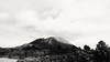
The location given is approximate and actually cites the peak of the Paricutin Volcano which towers over the dig site.
Note: Bizarre dentures. See the attached article on this burial:
You may be viewing yesterday's version of this page. To see the most up to date information please register for a free account.
Do not use the above information on other web sites or publications without permission of the contributor.
Nearby Images from Flickr
The above images may not be of the site on this page, but were taken nearby. They are loaded from Flickr so please click on them for image credits.
Click here to see more info for this site
Nearby sites
Click here to view sites on an interactive map of the areaKey: Red: member's photo, Blue: 3rd party photo, Yellow: other image, Green: no photo - please go there and take one, Grey: site destroyed
Download sites to:
KML (Google Earth)
GPX (GPS waypoints)
CSV (Garmin/Navman)
CSV (Excel)
To unlock full downloads you need to sign up as a Contributory Member. Otherwise downloads are limited to 50 sites.
Turn off the page maps and other distractions
Nearby sites listing. In the following links * = Image available
41.1km E 86° Tingambato* Ancient Village or Settlement
49.5km ESE 112° Tipitarillo Yacata Pyramid / Mastaba
67.0km E 79° Ihuatzio* Ancient Village or Settlement
73.0km ENE 76° Tzintzuntzan* Ancient Village or Settlement
79.3km ENE 74° Purépecha Proto Urban Site Ancient Village or Settlement
79.3km E 81° Sacapu Angamuco Ancient Village or Settlement
116.5km ENE 59° Huandacareo Ancient Village or Settlement
156.7km W 261° Colima - Eastern Shaft Tomb* Barrow Cemetery
207.4km NE 41° Cañada de la Virgen Ancient Village or Settlement
214.8km NW 310° Los Guachimontones* Ancient Temple
224.0km ENE 57° El Cerrito Pyramid / Mastaba
236.3km SSE 156° Xihuacan Pyramid / Mastaba
254.5km NNW 330° El Teul Archaeological Zone Ancient Village or Settlement
256.0km ENE 77° Huamango Ancient Village or Settlement
264.6km E 98° Nevado de Toluca Natural Stone / Erratic / Other Natural Feature
281.4km E 98° Teotenango* Ancient Temple
312.1km ENE 77° Tula.* Ancient Village or Settlement
318.9km ESE 103° Xochicalco* Ancient Village or Settlement
321.2km E 90° Museo Nacional de Antropología* Museum
322.4km E 93° Cuicuilco* Pyramid / Mastaba
322.6km E 88° Acatitlan* Ancient Temple
323.1km E 88° Tenayuca* Pyramid / Mastaba
323.5km E 100° Cuernavaca - Piramide de Teopanzolco* Pyramid / Mastaba
323.6km ESE 112° Xihuatoxtla Cave or Rock Shelter
324.0km E 93° Tlalpan Ancient Village or Settlement
View more nearby sites and additional images


 We would like to know more about this location. Please feel free to add a brief description and any relevant information in your own language.
 Wir möchten mehr über diese Stätte erfahren. Bitte zögern Sie nicht, eine kurze Beschreibung und relevante Informationen in Deutsch hinzuzufügen.
 Nous aimerions en savoir encore un peu sur les lieux. S'il vous plaît n'hesitez pas à ajouter une courte description et tous les renseignements pertinents dans votre propre langue.
 Quisieramos informarnos un poco más de las lugares. No dude en añadir una breve descripción y otros datos relevantes en su propio idioma.